Varnița elevation
Varnița (Prahova, Comuna Şirna), Romania elevation is 139 meters and Varnița elevation in feet is 456 ft above sea level [src 1]. Varnița is a populated place (feature code) with elevation that is 113 meters (371 ft) smaller than average city elevation in Romania.
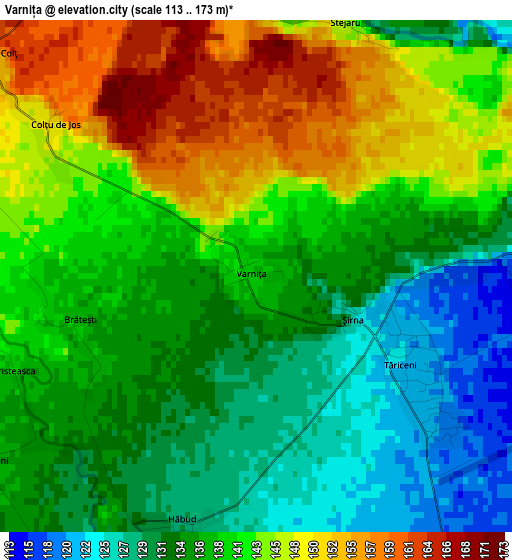
Below is the Elevation map of Varnița, which displays elevation range with different colors. Scale of the first map is from 113 to 173 m (371 to 568 ft) with average elevation of 138.8 meters (=455 ft) [note 1]
These maps also provides idea of topography and contour of this city, they are displayed at different zoom levels. More info about maps, scale and edge coordinates you can find below images.
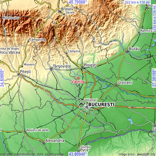
| \ | Map #1 | Topo.Map |
| Scale [m] | 113..173 m | × |
| Scale [ft] | 371..568 ft | × |
| Average | 138.8 m = 455 ft | × |
| Width | 6.93 km = 4.3 mi | 221.9 km = 137.9 mi |
| Height | 6.93 km = 4.3 mi | 221.9 km = 137.9 mi |
| ↑Max Latitude | 44.83796° | 45.79588° |
| Latitude at center | 44.80679° | 44.80679° |
| ↓Min Latitude | 44.775603° | 43.80045° |
| ← Min Longitude | 25.901355° | 24.53905° |
| Longitude center | 25.9453° | 25.9453° |
| →Max Longitude | 25.989245° | 27.35155° |
Nearby cities:
Cities around Varnița sort by population:
• Târgşoru Vechi elevation 162 m
7 km,  341°
341°
• Brazii de Sus 132 m
8.7 km,  40°
40°
• Corneşti 141 m
6.7 km,  247°
247°
• Şirna 133 m
0.8 km,  153°
153°
• Tinosu 113 m
5.7 km,  78°
78°
• Tăriceni 123 m
2.2 km,  121°
121°
• Ologeni 120 m
8.1 km,  177°
177°
• Negoiești 146 m
8 km,  20°
20°
• Popești 136 m
7.2 km,  33°
33°
• Buriaș 119 m
8.7 km,  161°
161°
• Poienarii Burchii 113 m
8.5 km,  138°
138°
• Cocorăștii Colț 155 m
4.7 km,  310°
310°
Multilingual:
 En español:
Varnița elevación 139 m.
 En France:
Varnița élévation 139 m.


Sources and notes:
- [note 1] Map square and city borders are not equal. Map elevation data is calculated only from area inside that square.
- [src 1] Elevation data from geonames database provided with same terms of usage.
- [src 2] The elevation map of Varnița is generated using elevation data from NASA's 3 arcsec (90m) resolution SRTM data.
- [src 3] Base (background) map © OpenStreetMap contributors tiles are generated by Geofabrik and OpenTopoMap.
Copyright & License:
This Varnița Elevation Map is licensed under CC BY-SA. You may reuse any part from this page, if you give a proper credit by linking to this URL:
 More info on terms of use page.