Târgu Lăpuş elevation
Târgu Lăpuş (Maramureş, Oraș Târgu Lăpuş), Romania elevation is 333 meters and Târgu Lăpuş elevation in feet is 1093 ft above sea level [src 1]. Târgu Lăpuş is a seat of a second-order administrative division (feature code) with elevation that is 81 meters (266 ft) bigger than average city elevation in Romania.
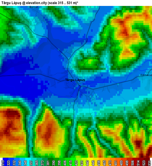
Below is the Elevation map of Târgu Lăpuş, which displays elevation range with different colors. Scale of the first map is from 315 to 531 m (1033 to 1742 ft) with average elevation of 379 meters (=1243 ft) [note 1]
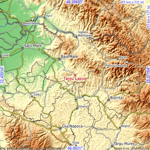
These maps also provides idea of topography and contour of this city, they are displayed at different zoom levels. More info about maps, scale and edge coordinates you can find below images.
| \ | Map #1 | Topo.Map |
| Scale [m] | 315..531 m | × |
| Scale [ft] | 1033..1742 ft | × |
| Average | 379 m = 1243 ft | × |
| Width | 6.61 km = 4.1 mi | 211.5 km = 131.4 mi |
| Height | 6.61 km = 4.1 mi | 211.5 km = 131.4 mi |
| ↑Max Latitude | 47.482317° | 48.39493° |
| Latitude at center | 47.45261° | 47.45261° |
| ↓Min Latitude | 47.422886° | 46.4931° |
| ← Min Longitude | 23.821445° | 22.45914° |
| Longitude center | 23.86539° | 23.86539° |
| →Max Longitude | 23.909335° | 25.27164° |
Nearby cities:
Cities around Târgu Lăpuş sort by population:
• Suciu de Sus elevation 418 m
12.8 km,  99°
99°
• Lăpuş 390 m
12.5 km,  65°
65°
• Cerneşti 306 m
11.2 km,  309°
309°
• Cupşeni 488 m
12 km,  25°
25°
• Ungureni 387 m
12.3 km, 32°
• Vima Mică 459 m
12.6 km,  242°
242°
• Rogoz 351 m
5.3 km, 71°
• Suciu de Jos 379 m
8.8 km,  94°
94°
• Libotin 374 m
9.7 km,  52°
52°
• Borcut 343 m
3.8 km,  330°
330°
• Dămăcușeni 341 m
3.3 km,  81°
81°
• Coroieni 394 m
12.1 km,  217°
217°
Multilingual:
 En español:
Târgu Lăpuş elevación 333 m.
 En France:
Târgu Lăpuş élévation 333 m.
 Auf Deutsch:
Târgu Lăpuş höhe über dem Meeresspiegel ist 333 m.

Sources and notes:
- [note 1] Map square and city borders are not equal. Map elevation data is calculated only from area inside that square.
- [src 1] Elevation data from geonames database provided with same terms of usage.
- [src 2] The elevation map of Târgu Lăpuş is generated using elevation data from NASA's 3 arcsec (90m) resolution SRTM data.
- [src 3] Base (background) map © OpenStreetMap contributors tiles are generated by Geofabrik and OpenTopoMap.
Copyright & License:
This Târgu Lăpuş Elevation Map is licensed under CC BY-SA. You may reuse any part from this page, if you give a proper credit by linking to this URL:
 More info on terms of use page.