Topoloveni elevation
Topoloveni (Arges, Oraș Topoloveni), Romania elevation is 243 meters and Topoloveni elevation in feet is 797 ft above sea level [src 1]. Topoloveni is a seat of a second-order administrative division (feature code) with elevation that is 9 meters (30 ft) smaller than average city elevation in Romania.
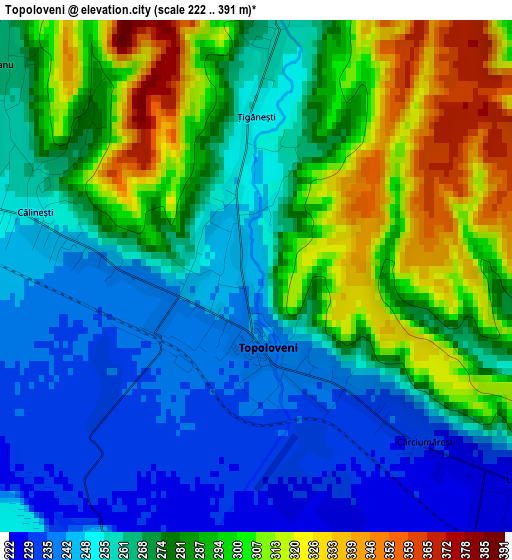
Below is the Elevation map of Topoloveni, which displays elevation range with different colors. Scale of the first map is from 222 to 391 m (728 to 1283 ft) with average elevation of 274.2 meters (=900 ft) [note 1]
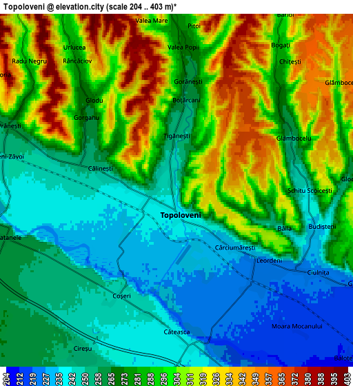
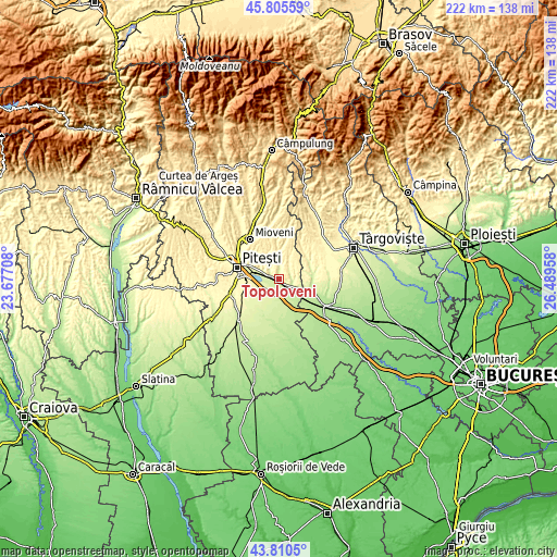
These maps also provides idea of topography and contour of this city, they are displayed at different zoom levels. More info about maps, scale and edge coordinates you can find below images.
| \ | Map #1 | Map #2 | Topo.Map |
| Scale [m] | 222..391 m | 204..403 m | × |
| Scale [ft] | 728..1283 ft | 669..1322 ft | × |
| Average | 274.2 m = 900 ft | 278.2 m = 913 ft | × |
| Width | 6.93 km = 4.3 mi | 13.86 km = 8.6 mi | 221.8 km = 137.8 mi |
| Height | 6.93 km = 4.3 mi | 13.86 km = 8.6 mi | 221.8 km = 137.8 mi |
| ↑Max Latitude | 44.847835° | 44.878983° | 45.80559° |
| Latitude at center | 44.81667° | 44.81667° | 44.81667° |
| ↓Min Latitude | 44.785488° | 44.75429° | 43.8105° |
| ← Min Longitude | 25.039385° | 24.995439° | 23.67708° |
| Longitude center | 25.08333° | 25.08333° | 25.08333° |
| →Max Longitude | 25.127275° | 25.171221° | 26.48958° |
Nearby cities:
Cities around Topoloveni sort by population:
• Călineşti elevation 240 m
2.6 km,  270°
270°
• Leordeni 224 m
4.5 km,  144°
144°
• Bogaţi 287 m
6.8 km,  35°
35°
• Popeşti 241 m
5.7 km,  193°
193°
• Căteasca 238 m
5.6 km,  180°
180°
• Priboieni 279 m
7.4 km,  0°
0°
• Beleţi 294 m
9.3 km, 0°
• Vrănești 273 m
6.8 km,  298°
298°
• Gorganu 267 m
4.6 km,  308°
308°
• Golești 253 m
9.7 km,  285°
285°
• Văleni-Podgoria 283 m
8.7 km, 301°
• Ciulnița 225 m
6.4 km,  120°
120°
Multilingual:
 En español:
Topoloveni elevación 243 m.
 En France:
Topoloveni élévation 243 m.
 Auf Deutsch:
Topoloveni höhe über dem Meeresspiegel ist 243 m.

Sources and notes:
- [note 1] Map square and city borders are not equal. Map elevation data is calculated only from area inside that square.
- [src 1] Elevation data from geonames database provided with same terms of usage.
- [src 2] The elevation map of Topoloveni is generated using elevation data from NASA's 3 arcsec (90m) resolution SRTM data.
- [src 3] Base (background) map © OpenStreetMap contributors tiles are generated by Geofabrik and OpenTopoMap.
Copyright & License:
This Topoloveni Elevation Map is licensed under CC BY-SA. You may reuse any part from this page, if you give a proper credit by linking to this URL:
 More info on terms of use page.