Tudora elevation
Tudora (Botoşani, Comuna Tudora), Romania elevation is 286 meters and Tudora elevation in feet is 938 ft above sea level [src 1]. Tudora is a seat of a second-order administrative division (feature code) with elevation that is 34 meters (112 ft) bigger than average city elevation in Romania.
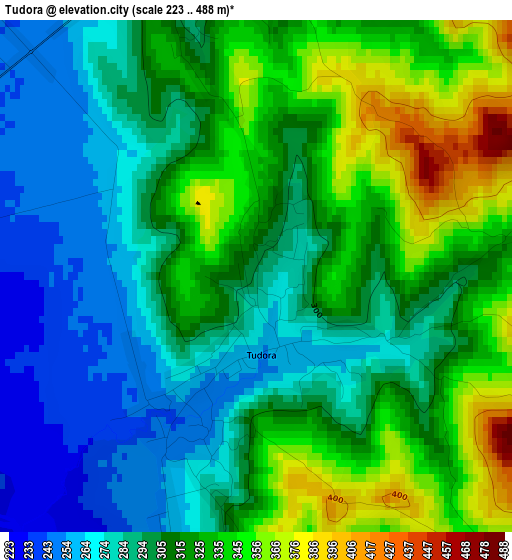
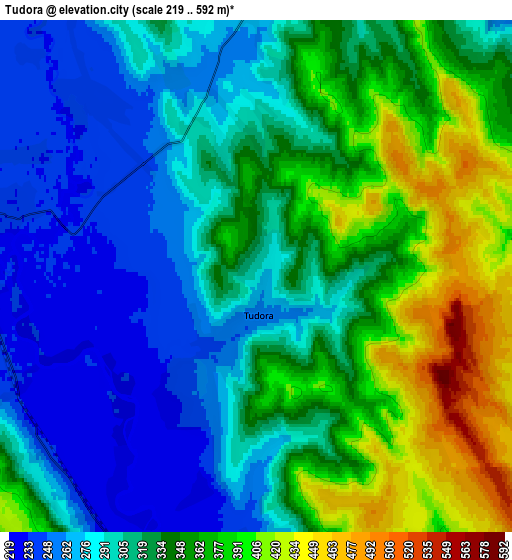
Below is the Elevation map of Tudora, which displays elevation range with different colors. Scale of the first map is from 223 to 488 m (732 to 1601 ft) with average elevation of 308.6 meters (=1012 ft) [note 1]
These maps also provides idea of topography and contour of this city, they are displayed at different zoom levels. More info about maps, scale and edge coordinates you can find below images.
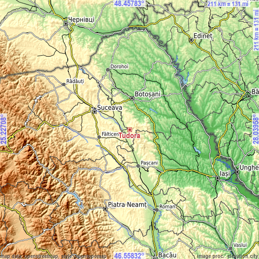
| \ | Map #1 | Map #2 | Topo.Map |
| Scale [m] | 223..488 m | 219..592 m | × |
| Scale [ft] | 732..1601 ft | 719..1942 ft | × |
| Average | 308.6 m = 1012 ft | 326.4 m = 1071 ft | × |
| Width | 6.6 km = 4.1 mi | 13.2 km = 8.2 mi | 211.2 km = 131.2 mi |
| Height | 6.6 km = 4.1 mi | 13.2 km = 8.2 mi | 211.2 km = 131.2 mi |
| ↑Max Latitude | 47.546341° | 47.575996° | 48.45783° |
| Latitude at center | 47.51667° | 47.51667° | 47.51667° |
| ↓Min Latitude | 47.486982° | 47.457277° | 46.55832° |
| ← Min Longitude | 26.589385° | 26.545439° | 25.22708° |
| Longitude center | 26.63333° | 26.63333° | 26.63333° |
| →Max Longitude | 26.677275° | 26.721221° | 28.03958° |
Nearby cities:
Cities around Tudora sort by population:
• Dolhasca elevation 231 m
9.6 km,  195°
195°
• Vorona Teodoru 253 m
4.5 km,  325°
325°
• Liteni 247 m
7.9 km,  273°
273°
• Vorona 272 m
6.7 km,  358°
358°
• Rotunda 273 m
8.8 km,  248°
248°
• Oneaga 203 m
10 km,  48°
48°
• Poiana 275 m
9.6 km,  348°
348°
• Icușeni 330 m
8.9 km,  341°
341°
• Dolheștii Mici 259 m
10.8 km,  214°
214°
• Joldești 240 m
6.4 km,  318°
318°
• Roșcani 232 m
6.6 km,  286°
286°
• Fântânele 240 m
9.9 km,  310°
310°
Multilingual:
 En español:
Tudora elevación 286 m.
 En France:
Tudora élévation 286 m.


Sources and notes:
- [note 1] Map square and city borders are not equal. Map elevation data is calculated only from area inside that square.
- [src 1] Elevation data from geonames database provided with same terms of usage.
- [src 2] The elevation map of Tudora is generated using elevation data from NASA's 3 arcsec (90m) resolution SRTM data.
- [src 3] Base (background) map © OpenStreetMap contributors tiles are generated by Geofabrik and OpenTopoMap.
Copyright & License:
This Tudora Elevation Map is licensed under CC BY-SA. You may reuse any part from this page, if you give a proper credit by linking to this URL:
 More info on terms of use page.