Fântânele elevation
Fântânele (Suceava, Comuna Fântânele), Romania elevation is 240 meters and Fântânele elevation in feet is 787 ft above sea level [src 1]. Fântânele is a seat of a second-order administrative division (feature code) with elevation that is 12 meters (39 ft) smaller than average city elevation in Romania.
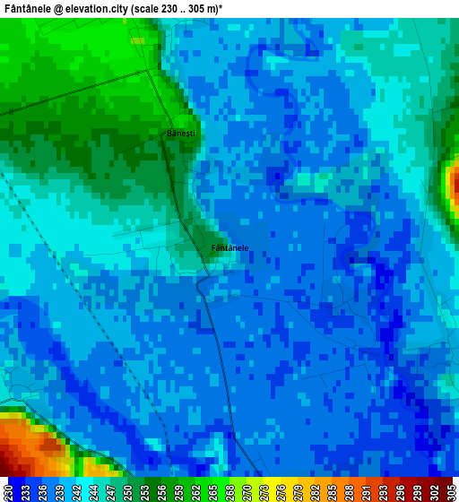
Below is the Elevation map of Fântânele, which displays elevation range with different colors. Scale of the first map is from 230 to 305 m (755 to 1001 ft) with average elevation of 243.2 meters (=798 ft) [note 1]
These maps also provides idea of topography and contour of this city, they are displayed at different zoom levels. More info about maps, scale and edge coordinates you can find below images.
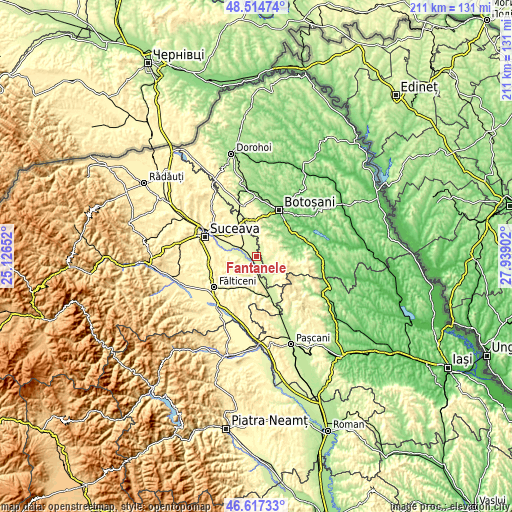
| \ | Map #1 | Topo.Map |
| Scale [m] | 230..305 m | × |
| Scale [ft] | 755..1001 ft | × |
| Average | 243.2 m = 798 ft | × |
| Width | 6.59 km = 4.1 mi | 211 km = 131.1 mi |
| Height | 6.59 km = 4.1 mi | 211 km = 131.1 mi |
| ↑Max Latitude | 47.604268° | 48.51474° |
| Latitude at center | 47.57463° | 47.57463° |
| ↓Min Latitude | 47.544975° | 46.61733° |
| ← Min Longitude | 26.488825° | 25.12652° |
| Longitude center | 26.53277° | 26.53277° |
| →Max Longitude | 26.576715° | 27.93902° |
Nearby cities:
Cities around Fântânele sort by population:
• Vorona Teodoru elevation 253 m
5.7 km,  118°
118°
• Vereşti 246 m
8 km,  290°
290°
• Liteni 247 m
6 km,  183°
183°
• Vorona 272 m
7.4 km,  87°
87°
• Corocăiești 265 m
7.5 km,  330°
330°
• Stamate 247 m
3.7 km,  341°
341°
• Sarafinești 307 m
7.3 km,  49°
49°
• Poiana 275 m
6.4 km,  62°
62°
• Icușeni 330 m
5.2 km,  67°
67°
• Joldești 240 m
3.7 km, 116°
• Roșcani 232 m
4.7 km,  165°
165°
• Bănești 258 m
1.8 km, 336°
Multilingual:
 En español:
Fântânele elevación 240 m.
 En France:
Fântânele élévation 240 m.
 Auf Deutsch:
Fântânele höhe über dem Meeresspiegel ist 240 m.

Sources and notes:
- [note 1] Map square and city borders are not equal. Map elevation data is calculated only from area inside that square.
- [src 1] Elevation data from geonames database provided with same terms of usage.
- [src 2] The elevation map of Fântânele is generated using elevation data from NASA's 3 arcsec (90m) resolution SRTM data.
- [src 3] Base (background) map © OpenStreetMap contributors tiles are generated by Geofabrik and OpenTopoMap.
Copyright & License:
This Fântânele Elevation Map is licensed under CC BY-SA. You may reuse any part from this page, if you give a proper credit by linking to this URL:
 More info on terms of use page.