Videle elevation
Videle (Teleorman, Oraş Videle), Romania elevation is 104 meters and Videle elevation in feet is 341 ft above sea level [src 1]. Videle is a seat of a second-order administrative division (feature code) with elevation that is 148 meters (486 ft) smaller than average city elevation in Romania.
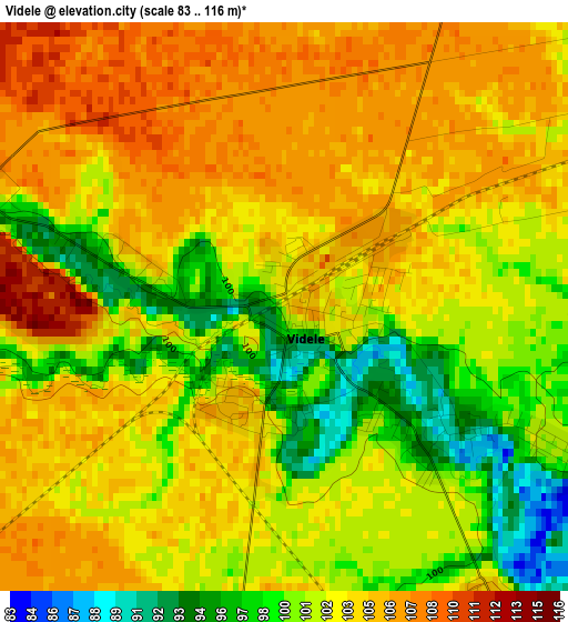
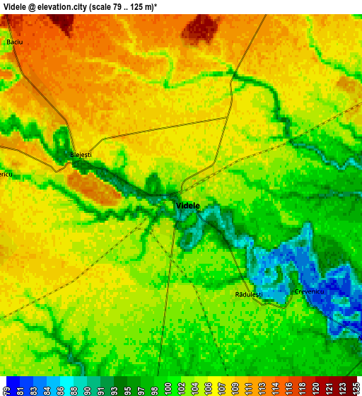
Below is the Elevation map of Videle, which displays elevation range with different colors. Scale of the first map is from 83 to 116 m (272 to 381 ft) with average elevation of 102.6 meters (=337 ft) [note 1]
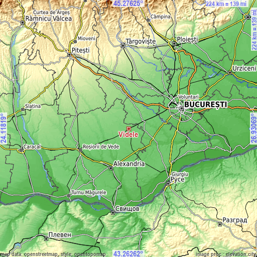
These maps also provides idea of topography and contour of this city, they are displayed at different zoom levels. More info about maps, scale and edge coordinates you can find below images.
| \ | Map #1 | Map #2 | Topo.Map |
| Scale [m] | 83..116 m | 79..125 m | × |
| Scale [ft] | 272..381 ft | 259..410 ft | × |
| Average | 102.6 m = 337 ft | 103.7 m = 340 ft | × |
| Width | 7 km = 4.3 mi | 13.99 km = 8.7 mi | 223.9 km = 139.1 mi |
| Height | 7 km = 4.3 mi | 13.99 km = 8.7 mi | 223.9 km = 139.1 mi |
| ↑Max Latitude | 44.309515° | 44.340952° | 45.27625° |
| Latitude at center | 44.27806° | 44.27806° | 44.27806° |
| ↓Min Latitude | 44.246588° | 44.2151° | 43.26262° |
| ← Min Longitude | 25.480495° | 25.436549° | 24.11819° |
| Longitude center | 25.52444° | 25.52444° | 25.52444° |
| →Max Longitude | 25.568385° | 25.612331° | 26.93069° |
Nearby cities:
Cities around Videle sort by population:
• Blejeşti elevation 99 m
5.2 km,  297°
297°
• Ciuani 76 m
11.2 km,  116°
116°
• Mârşa 99 m
11 km,  13°
13°
• Cosmeşti 112 m
11.5 km,  282°
282°
• Valea Cireșului 89 m
12.8 km,  165°
165°
• Merenii de Jos 76 m
10.8 km, 118°
• Moșteni 99 m
9 km,  188°
188°
• Crevenicu 82 m
6.6 km,  129°
129°
• Ciuperceni 117 m
12.4 km,  290°
290°
• Merenii de Sus 86 m
9.5 km, 125°
• Baciu 115 m
8.7 km,  312°
312°
• Purani 122 m
12.2 km,  319°
319°
Multilingual:
 En español:
Videle elevación 104 m.
 En France:
Videle élévation 104 m.


Sources and notes:
- [note 1] Map square and city borders are not equal. Map elevation data is calculated only from area inside that square.
- [src 1] Elevation data from geonames database provided with same terms of usage.
- [src 2] The elevation map of Videle is generated using elevation data from NASA's 3 arcsec (90m) resolution SRTM data.
- [src 3] Base (background) map © OpenStreetMap contributors tiles are generated by Geofabrik and OpenTopoMap.
Copyright & License:
This Videle Elevation Map is licensed under CC BY-SA. You may reuse any part from this page, if you give a proper credit by linking to this URL:
 More info on terms of use page.