Vidra elevation
Vidra (Ilfov, Comuna Vidra), Romania elevation is 53 meters and Vidra elevation in feet is 174 ft above sea level [src 1]. Vidra is a seat of a second-order administrative division (feature code) with elevation that is 199 meters (653 ft) smaller than average city elevation in Romania.
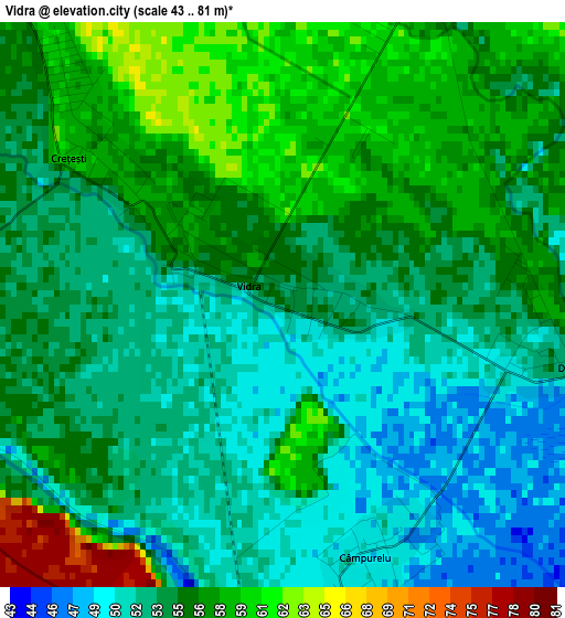
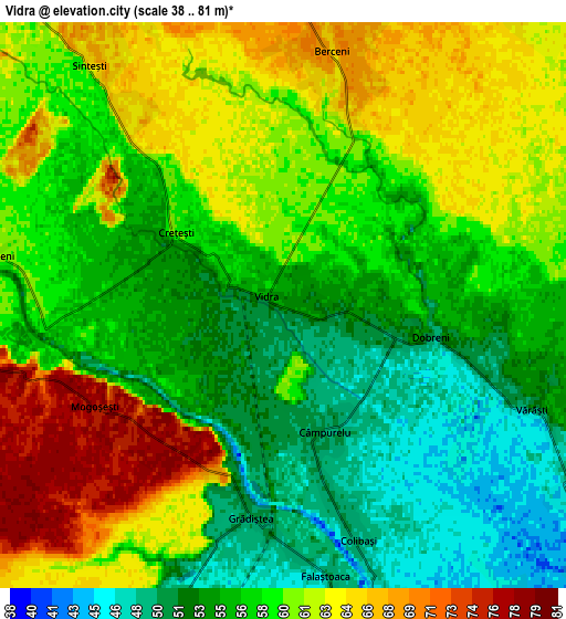
Below is the Elevation map of Vidra, which displays elevation range with different colors. Scale of the first map is from 43 to 81 m (141 to 266 ft) with average elevation of 54.7 meters (=179 ft) [note 1]
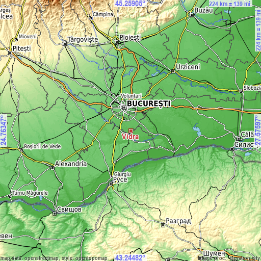
These maps also provides idea of topography and contour of this city, they are displayed at different zoom levels. More info about maps, scale and edge coordinates you can find below images.
| \ | Map #1 | Map #2 | Topo.Map |
| Scale [m] | 43..81 m | 38..81 m | × |
| Scale [ft] | 141..266 ft | 125..266 ft | × |
| Average | 54.7 m = 179 ft | 58.2 m = 191 ft | × |
| Width | 7 km = 4.3 mi | 14 km = 8.7 mi | 224 km = 139.2 mi |
| Height | 7 km = 4.3 mi | 14 km = 8.7 mi | 224 km = 139.2 mi |
| ↑Max Latitude | 44.292024° | 44.323471° | 45.25905° |
| Latitude at center | 44.26056° | 44.26056° | 44.26056° |
| ↓Min Latitude | 44.229079° | 44.197581° | 43.24482° |
| ← Min Longitude | 26.125775° | 26.081829° | 24.76347° |
| Longitude center | 26.16972° | 26.16972° | 26.16972° |
| →Max Longitude | 26.213665° | 26.257611° | 27.57597° |
Nearby cities:
Cities around Vidra sort by population:
• Vărăşti elevation 51 m
6.8 km,  111°
111°
• Berceni 65 m
6.1 km,  11°
11°
• Colibaşi 48 m
6.8 km,  162°
162°
• Copăceni 59 m
6.1 km,  272°
272°
• Goştinari-Văcăreşti 39 m
9.4 km, 156°
• Crețești 60 m
3.7 km,  311°
311°
• Dobreni 53 m
3.6 km,  101°
101°
• Sintești 65 m
5.9 km,  318°
318°
• Gostinari 46 m
9.5 km,  150°
150°
• Grădiștea 49 m
5.6 km,  183°
183°
• Câmpurelu 49 m
3.3 km, 154°
• Falaștoaca 47 m
7.8 km,  171°
171°
Multilingual:
 En español:
Vidra elevación 53 m.
 En France:
Vidra élévation 53 m.


Sources and notes:
- [note 1] Map square and city borders are not equal. Map elevation data is calculated only from area inside that square.
- [src 1] Elevation data from geonames database provided with same terms of usage.
- [src 2] The elevation map of Vidra is generated using elevation data from NASA's 3 arcsec (90m) resolution SRTM data.
- [src 3] Base (background) map © OpenStreetMap contributors tiles are generated by Geofabrik and OpenTopoMap.
Copyright & License:
This Vidra Elevation Map is licensed under CC BY-SA. You may reuse any part from this page, if you give a proper credit by linking to this URL:
 More info on terms of use page.