Viişoara elevation
Viişoara (Botoşani, Comuna Viişoara), Romania elevation is 147 meters and Viişoara elevation in feet is 482 ft above sea level [src 1]. Viişoara is a seat of a second-order administrative division (feature code) with elevation that is 105 meters (344 ft) smaller than average city elevation in Romania.
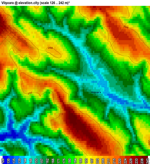
Below is the Elevation map of Viişoara, which displays elevation range with different colors. Scale of the first map is from 126 to 242 m (413 to 794 ft) with average elevation of 181.9 meters (=597 ft) [note 1]
These maps also provides idea of topography and contour of this city, they are displayed at different zoom levels. More info about maps, scale and edge coordinates you can find below images.
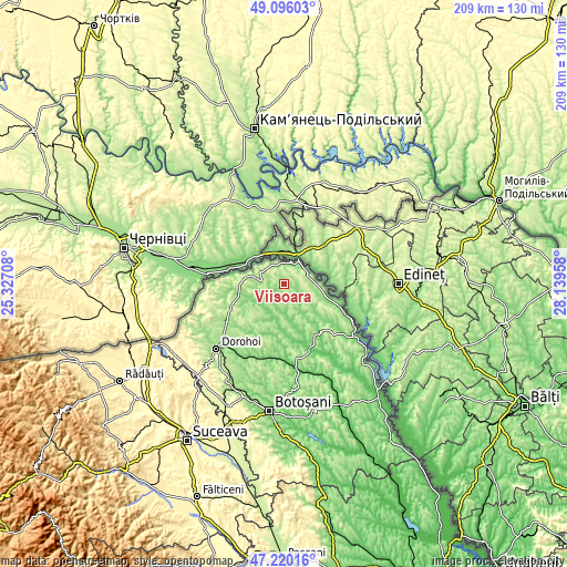
| \ | Map #1 | Topo.Map |
| Scale [m] | 126..242 m | × |
| Scale [ft] | 413..794 ft | × |
| Average | 181.9 m = 597 ft | × |
| Width | 6.52 km = 4.1 mi | 208.6 km = 129.6 mi |
| Height | 6.52 km = 4.1 mi | 208.6 km = 129.6 mi |
| ↑Max Latitude | 48.195972° | 49.09603° |
| Latitude at center | 48.16667° | 48.16667° |
| ↓Min Latitude | 48.137352° | 47.22016° |
| ← Min Longitude | 26.689385° | 25.32708° |
| Longitude center | 26.73333° | 26.73333° |
| →Max Longitude | 26.777275° | 28.13958° |
Nearby cities:
Cities around Viişoara sort by population:
• Darabani elevation 222 m
11.3 km,  279°
279°
• Hudeşti 191 m
17.4 km,  263°
263°
• Coţuşca 189 m
9.4 km,  113°
113°
• Havârna 131 m
12.7 km,  209°
209°
• Păltiniş 231 m
8.3 km,  311°
311°
• Mileanca 122 m
9.6 km,  194°
194°
• Drăguşeni 143 m
17.8 km,  159°
159°
• Miorcani 182 m
9.7 km,  65°
65°
• Conceşti 232 m
13.6 km,  270°
270°
• Bajura 197 m
14.8 km, 284°
• Rediu 129 m
7.9 km,  25°
25°
• Rădăuți-Prut 119 m
8.9 km, 33°
Multilingual:
 En español:
Viişoara elevación 147 m.
 En France:
Viişoara élévation 147 m.
 Auf Deutsch:
Viişoara höhe über dem Meeresspiegel ist 147 m.

Sources and notes:
- [note 1] Map square and city borders are not equal. Map elevation data is calculated only from area inside that square.
- [src 1] Elevation data from geonames database provided with same terms of usage.
- [src 2] The elevation map of Viişoara is generated using elevation data from NASA's 3 arcsec (90m) resolution SRTM data.
- [src 3] Base (background) map © OpenStreetMap contributors tiles are generated by Geofabrik and OpenTopoMap.
Copyright & License:
This Viişoara Elevation Map is licensed under CC BY-SA. You may reuse any part from this page, if you give a proper credit by linking to this URL:
 More info on terms of use page.