Vurpăr elevation
Vurpăr (Alba, Comuna Vinţu de Jos), Romania elevation is 218 meters and Vurpăr elevation in feet is 715 ft above sea level [src 1]. Vurpăr is a populated place (feature code) with elevation that is 34 meters (112 ft) smaller than average city elevation in Romania.
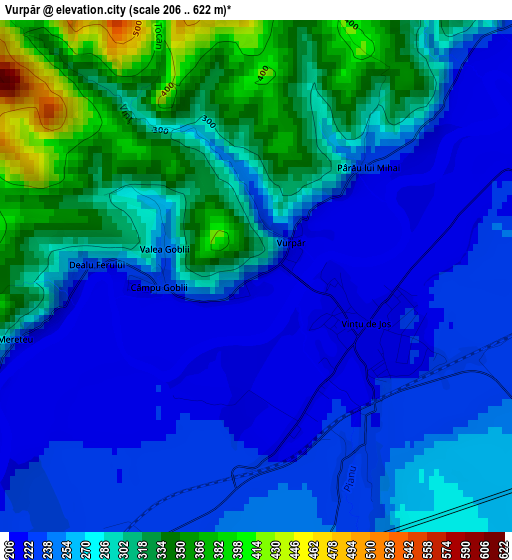
Below is the Elevation map of Vurpăr, which displays elevation range with different colors. Scale of the first map is from 206 to 622 m (676 to 2041 ft) with average elevation of 271 meters (=889 ft) [note 1]
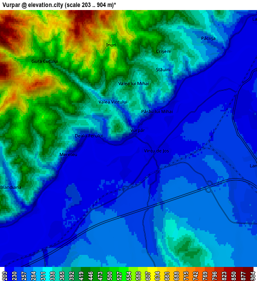
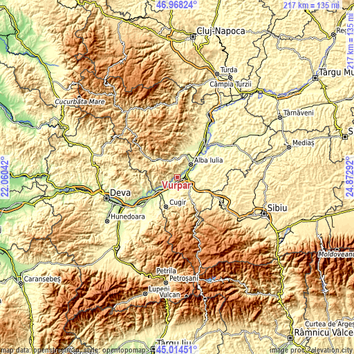
These maps also provides idea of topography and contour of this city, they are displayed at different zoom levels. More info about maps, scale and edge coordinates you can find below images.
| \ | Map #1 | Map #2 | Topo.Map |
| Scale [m] | 206..622 m | 203..904 m | × |
| Scale [ft] | 676..2041 ft | 666..2966 ft | × |
| Average | 271 m = 889 ft | 337.4 m = 1107 ft | × |
| Width | 6.79 km = 4.2 mi | 13.58 km = 8.4 mi | 217.2 km = 135 mi |
| Height | 6.79 km = 4.2 mi | 13.58 km = 8.4 mi | 217.2 km = 135 mi |
| ↑Max Latitude | 46.030519° | 46.06102° | 46.96824° |
| Latitude at center | 46° | 46° | 46° |
| ↓Min Latitude | 45.969465° | 45.938912° | 45.01451° |
| ← Min Longitude | 23.422725° | 23.378779° | 22.06042° |
| Longitude center | 23.46667° | 23.46667° | 23.46667° |
| →Max Longitude | 23.510615° | 23.554561° | 24.87292° |
Nearby cities:
Cities around Vurpăr sort by population:
• Alba Iulia elevation 219 m
11.7 km,  50°
50°
• Sebeş 254 m
9.4 km,  120°
120°
• Petrești 275 m
11.4 km,  140°
140°
• Pianu de Sus 309 m
11.2 km,  173°
173°
• Meteş 346 m
11.8 km,  340°
340°
• Vințu de Jos 215 m
1.6 km,  111°
111°
• Şibot 205 m
11.7 km,  241°
241°
• Oarda 219 m
8.6 km,  64°
64°
• Lancrăm 238 m
7.1 km,  101°
101°
• Săliștea 251 m
11.6 km,  207°
207°
• Blândiana 260 m
6.7 km,  249°
249°
• Pianu de Jos 267 m
7.4 km, 166°
Multilingual:
 En español:
Vurpăr elevación 218 m.
 En France:
Vurpăr élévation 218 m.


Sources and notes:
- [note 1] Map square and city borders are not equal. Map elevation data is calculated only from area inside that square.
- [src 1] Elevation data from geonames database provided with same terms of usage.
- [src 2] The elevation map of Vurpăr is generated using elevation data from NASA's 3 arcsec (90m) resolution SRTM data.
- [src 3] Base (background) map © OpenStreetMap contributors tiles are generated by Geofabrik and OpenTopoMap.
Copyright & License:
This Vurpăr Elevation Map is licensed under CC BY-SA. You may reuse any part from this page, if you give a proper credit by linking to this URL:
 More info on terms of use page.