Zencani elevation
Zencani (Harghita, Municipiul Topliţa), Romania elevation is 663 meters and Zencani elevation in feet is 2175 ft above sea level [src 1]. Zencani is a section of populated place (feature code) with elevation that is 411 meters (1348 ft) bigger than average city elevation in Romania.
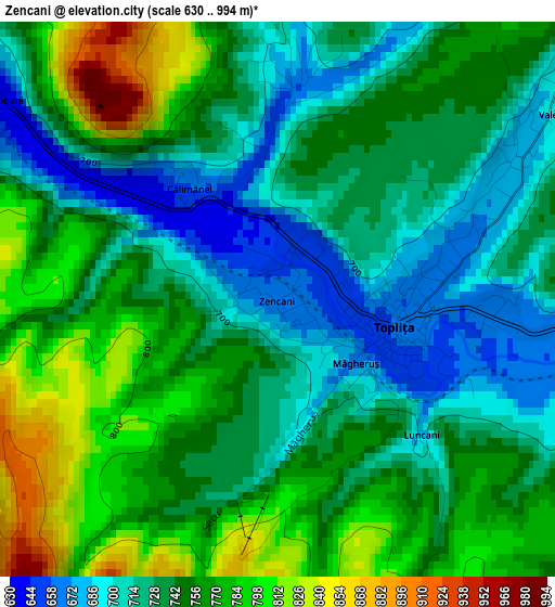
Below is the Elevation map of Zencani, which displays elevation range with different colors. Scale of the first map is from 630 to 994 m (2067 to 3261 ft) with average elevation of 744.4 meters (=2442 ft) [note 1]
These maps also provides idea of topography and contour of this city, they are displayed at different zoom levels. More info about maps, scale and edge coordinates you can find below images.
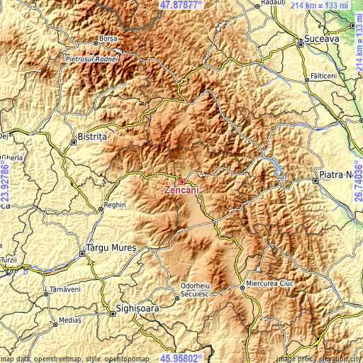
| \ | Map #1 | Topo.Map |
| Scale [m] | 630..994 m | × |
| Scale [ft] | 2067..3261 ft | × |
| Average | 744.4 m = 2442 ft | × |
| Width | 6.67 km = 4.1 mi | 213.6 km = 132.7 mi |
| Height | 6.67 km = 4.1 mi | 213.6 km = 132.7 mi |
| ↑Max Latitude | 46.957003° | 47.87877° |
| Latitude at center | 46.927° | 46.927° |
| ↓Min Latitude | 46.89698° | 45.95802° |
| ← Min Longitude | 25.290165° | 23.92786° |
| Longitude center | 25.33411° | 25.33411° |
| →Max Longitude | 25.378055° | 26.74036° |
Nearby cities:
Cities around Zencani sort by population:
• Remetea elevation 724 m
18.2 km,  151°
151°
• Ditrău 779 m
18.5 km,  131°
131°
• Sărmaş 758 m
11.2 km,  115°
115°
• Lăzarea 775 m
24.8 km,  142°
142°
• Bilbor 958 m
19.5 km,  45°
45°
• Borsec 1064 m
17.8 km,  81°
81°
• Gălăuţaş 846 m
7.6 km,  98°
98°
• Lunca Bradului 579 m
17.2 km,  280°
280°
• Subcetate 727 m
12.3 km, 134°
• Vale 692 m
4.2 km, 54°
• Hodoșa 699 m
10.9 km, 128°
• Stânceni 882 m
9.9 km,  309°
309°
Multilingual:
 En español:
Zencani elevación 663 m.
 En France:
Zencani élévation 663 m.


Sources and notes:
- [note 1] Map square and city borders are not equal. Map elevation data is calculated only from area inside that square.
- [src 1] Elevation data from geonames database provided with same terms of usage.
- [src 2] The elevation map of Zencani is generated using elevation data from NASA's 3 arcsec (90m) resolution SRTM data.
- [src 3] Base (background) map © OpenStreetMap contributors tiles are generated by Geofabrik and OpenTopoMap.
Copyright & License:
This Zencani Elevation Map is licensed under CC BY-SA. You may reuse any part from this page, if you give a proper credit by linking to this URL:
 More info on terms of use page.