Zorleni elevation
Zorleni (Vaslui, Comuna Zorleni), Romania elevation is 70 meters and Zorleni elevation in feet is 230 ft above sea level [src 1]. Zorleni is a seat of a second-order administrative division (feature code) with elevation that is 182 meters (597 ft) smaller than average city elevation in Romania.
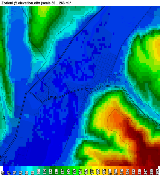
Below is the Elevation map of Zorleni, which displays elevation range with different colors. Scale of the first map is from 59 to 263 m (194 to 863 ft) with average elevation of 105 meters (=344 ft) [note 1]
These maps also provides idea of topography and contour of this city, they are displayed at different zoom levels. More info about maps, scale and edge coordinates you can find below images.
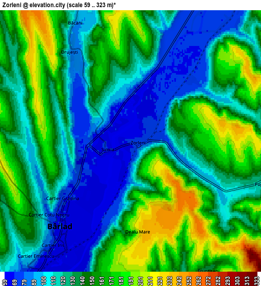
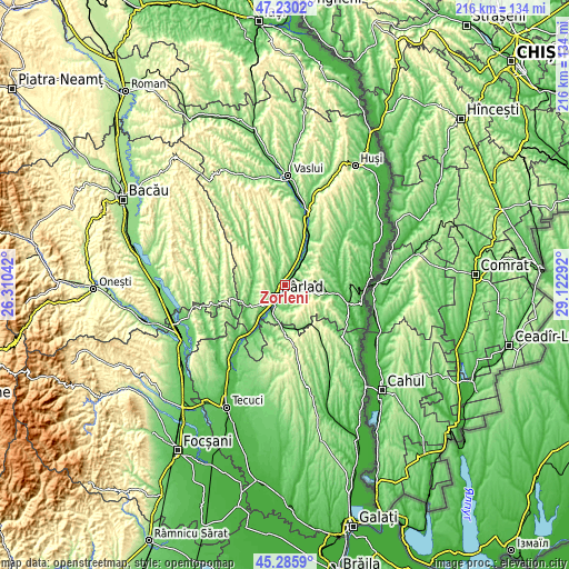
| \ | Map #1 | Map #2 | Topo.Map |
| Scale [m] | 59..263 m | 59..323 m | × |
| Scale [ft] | 194..863 ft | 194..1060 ft | × |
| Average | 105 m = 344 ft | 137.2 m = 450 ft | × |
| Width | 6.76 km = 4.2 mi | 13.51 km = 8.4 mi | 216.2 km = 134.3 mi |
| Height | 6.76 km = 4.2 mi | 13.51 km = 8.4 mi | 216.2 km = 134.3 mi |
| ↑Max Latitude | 46.297041° | 46.327395° | 47.2302° |
| Latitude at center | 46.26667° | 46.26667° | 46.26667° |
| ↓Min Latitude | 46.236282° | 46.205877° | 45.2859° |
| ← Min Longitude | 27.672725° | 27.628779° | 26.31042° |
| Longitude center | 27.71667° | 27.71667° | 27.71667° |
| →Max Longitude | 27.760615° | 27.804561° | 29.12292° |
Nearby cities:
Cities around Zorleni sort by population:
• Bârlad elevation 70 m
5.3 km,  223°
223°
• Banca 182 m
7.4 km,  59°
59°
• Griviţa 183 m
14 km,  201°
201°
• Perieni 241 m
8.5 km,  295°
295°
• Vinderei 239 m
14.5 km,  153°
153°
• Pogana 108 m
12.8 km, 295°
• Băcani 159 m
8.3 km,  332°
332°
• Popeni 116 m
7.2 km,  108°
108°
• Şuletea 204 m
14.2 km,  82°
82°
• Trestiana 65 m
9 km,  214°
214°
• Fruntișeni 136 m
7.8 km, 149°
• Ciocani 96 m
12.1 km,  266°
266°
Multilingual:
 En español:
Zorleni elevación 70 m.
 En France:
Zorleni élévation 70 m.


Sources and notes:
- [note 1] Map square and city borders are not equal. Map elevation data is calculated only from area inside that square.
- [src 1] Elevation data from geonames database provided with same terms of usage.
- [src 2] The elevation map of Zorleni is generated using elevation data from NASA's 3 arcsec (90m) resolution SRTM data.
- [src 3] Base (background) map © OpenStreetMap contributors tiles are generated by Geofabrik and OpenTopoMap.
Copyright & License:
This Zorleni Elevation Map is licensed under CC BY-SA. You may reuse any part from this page, if you give a proper credit by linking to this URL:
 More info on terms of use page.