Izvoarele elevation
Izvoarele (Prahova, Comuna Izvoarele), Romania elevation is 528 meters and Izvoarele elevation in feet is 1732 ft above sea level [src 1]. Izvoarele is a seat of a second-order administrative division (feature code) with elevation that is 276 meters (906 ft) bigger than average city elevation in Romania.
Below is the Elevation map of Izvoarele, which displays elevation range with different colors. Scale of the first map is from 402 to 921 m (1319 to 3022 ft) with average elevation of 566.1 meters (=1857 ft) [note 1]
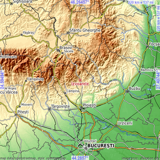
These maps also provides idea of topography and contour of this city, they are displayed at different zoom levels. More info about maps, scale and edge coordinates you can find below images.
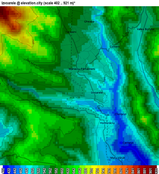
| \ | Map #1 | Topo.Map |
| Scale [m] | 402..921 m | × |
| Scale [ft] | 1319..3022 ft | × |
| Average | 566.1 m = 1857 ft | × |
| Width | 6.88 km = 4.3 mi | 220 km = 136.7 mi |
| Height | 6.88 km = 4.3 mi | 220 km = 136.7 mi |
| ↑Max Latitude | 45.314671° | 46.26457° |
| Latitude at center | 45.28376° | 45.28376° |
| ↓Min Latitude | 45.252832° | 44.2857° |
| ← Min Longitude | 25.957245° | 24.59494° |
| Longitude center | 26.00119° | 26.00119° |
| →Max Longitude | 26.045135° | 27.40744° |
Nearby cities:
Cities around Izvoarele sort by population:
• Slănic elevation 515 m
6.5 km,  234°
234°
• Drajna de Jos 381 m
8.4 km,  152°
152°
• Ceraşu 564 m
4.4 km,  34°
34°
• Teişani 473 m
5.8 km,  193°
193°
• Gheaba 548 m
2.9 km,  7°
7°
• Slon 625 m
8.6 km,  21°
21°
• Măneciu-Ungureni 634 m
3.9 km,  339°
339°
• Groșani 425 m
5.7 km, 226°
• Homorâciu 490 m
2 km,  143°
143°
• Schiulești 621 m
3.7 km,  271°
271°
• Drajna de Sus 461 m
6.4 km,  117°
117°
• Ogretin 450 m
7.4 km,  106°
106°
Multilingual:
 En español:
Izvoarele elevación 528 m.
 En France:
Izvoarele élévation 528 m.
 Auf Deutsch:
Izvoarele höhe über dem Meeresspiegel ist 528 m.

Sources and notes:
- [note 1] Map square and city borders are not equal. Map elevation data is calculated only from area inside that square.
- [src 1] Elevation data from geonames database provided with same terms of usage.
- [src 2] The elevation map of Izvoarele is generated using elevation data from NASA's 3 arcsec (90m) resolution SRTM data.
- [src 3] Base (background) map © OpenStreetMap contributors tiles are generated by Geofabrik and OpenTopoMap.
Copyright & License:
This Izvoarele Elevation Map is licensed under CC BY-SA. You may reuse any part from this page, if you give a proper credit by linking to this URL:
 More info on terms of use page.