Le Tampon elevation
Le Tampon (Réunion), Reunion elevation is 425 meters and Le Tampon elevation in feet is 1394 ft above sea level [src 1]. Le Tampon is a populated place (feature code) with elevation that is 234 meters (768 ft) bigger than average city elevation in Reunion.
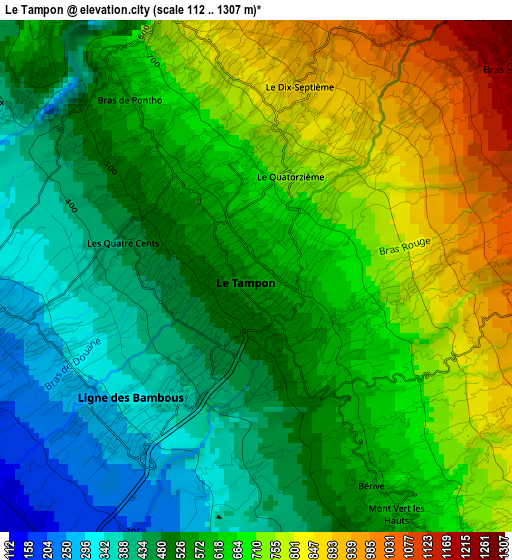
Below is the Elevation map of Le Tampon, which displays elevation range with different colors. Scale of the first map is from 112 to 1307 m (367 to 4288 ft) with average elevation of 602.9 meters (=1978 ft) [note 1]
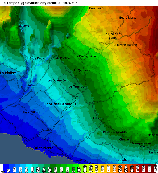
These maps also provides idea of topography and contour of this city, they are displayed at different zoom levels. More info about maps, scale and edge coordinates you can find below images.
| \ | Map #1 | Map #2 | Topo.Map |
| Scale [m] | 112..1307 m | 0..1974 m | × |
| Scale [ft] | 367..4288 ft | 0..6476 ft | × |
| Average | 602.9 m = 1978 ft | 718.8 m = 2358 ft | × |
| Width | 9.11 km = 5.7 mi | 18.21 km = 11.3 mi | 291.4 km = 181.1 mi |
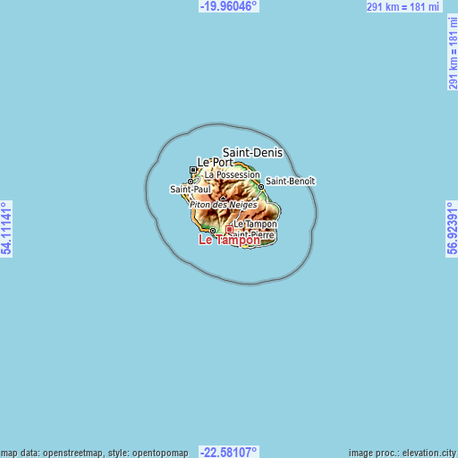
| Height | 9.11 km = 5.7 mi | 18.21 km = 11.3 mi | 291.4 km = 181.1 mi |
| ↑Max Latitude | -21.235644° | -21.194677° | -19.96046° |
| Latitude at center | -21.2766° | -21.2766° | -21.2766° |
| ↓Min Latitude | -21.317544° | -21.358477° | -22.58107° |
| ← Min Longitude | 55.473715° | 55.429769° | 54.11141° |
| Longitude center | 55.51766° | 55.51766° | 55.51766° |
| →Max Longitude | 55.561605° | 55.605551° | 56.92391° |
Nearby cities:
Cities around Le Tampon sort by population:
• Saint-Pierre elevation 36 m
8.1 km,  210°
210°
• Saint-Louis 40 m
11.1 km,  264°
264°
• Saint-Joseph 46 m
15.2 km,  137°
137°
• Piton Saint-Leu 294 m
21.9 km,  286°
286°
• Saint-Leu 10 m
26.5 km,  296°
296°
• Petite-Île 156 m
9.8 km,  150°
150°
• Les Avirons 138 m
19.2 km,  282°
282°
• Salazie 452 m
27.8 km,  4°
4°
• Les Trois-Bassins 801 m
29.9 km,  311°
311°
• Cilaos 887 m
16.3 km,  343°
343°
• Entre-Deux 445 m
7.1 km, 312°
• Saint-Philippe 25 m
27.6 km,  109°
109°
Multilingual:
 En español:
Le Tampon elevación 425 m.
 En France:
Le Tampon élévation 425 m.
 Auf Deutsch:
Le Tampon höhe über dem Meeresspiegel ist 425 m.

Sources and notes:
- [note 1] Map square and city borders are not equal. Map elevation data is calculated only from area inside that square.
- [src 1] Elevation data from geonames database provided with same terms of usage.
- [src 2] The elevation map of Le Tampon is generated using elevation data from NASA's 3 arcsec (90m) resolution SRTM data.
- [src 3] Base (background) map © OpenStreetMap contributors tiles are generated by Geofabrik and OpenTopoMap.
Copyright & License:
This Le Tampon Elevation Map is licensed under CC BY-SA. You may reuse any part from this page, if you give a proper credit by linking to this URL:
 More info on terms of use page.