Ciudad del Este elevation
Ciudad del Este (Alto Paraná, Ciudad Del Este), Paraguay elevation is 186 meters and Ciudad del Este elevation in feet is 610 ft above sea level [src 1]. Ciudad del Este is a seat of a first-order administrative division (feature code) with elevation that is 12 meters (39 ft) bigger than average city elevation in Paraguay.
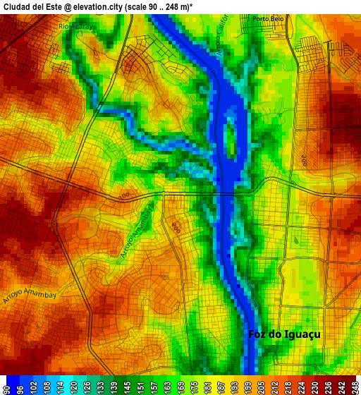
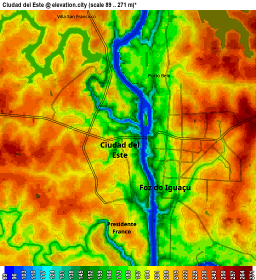
Below is the Elevation map of Ciudad del Este, which displays elevation range with different colors. Scale of the first map is from 90 to 248 m (295 to 814 ft) with average elevation of 184.6 meters (=606 ft) [note 1]
These maps also provides idea of topography and contour of this city, they are displayed at different zoom levels. More info about maps, scale and edge coordinates you can find below images.
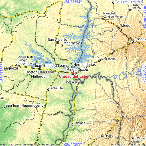
| \ | Map #1 | Map #2 | Topo.Map |
| Scale [m] | 90..248 m | 89..271 m | × |
| Scale [ft] | 295..814 ft | 292..889 ft | × |
| Average | 184.6 m = 606 ft | 201.1 m = 660 ft | × |
| Width | 8.82 km = 5.5 mi | 17.64 km = 11 mi | 282.2 km = 175.4 mi |
| Height | 8.82 km = 5.5 mi | 17.64 km = 11 mi | 282.2 km = 175.4 mi |
| ↑Max Latitude | -25.470052° | -25.430371° | -24.23394° |
| Latitude at center | -25.50972° | -25.50972° | -25.50972° |
| ↓Min Latitude | -25.549375° | -25.589016° | -26.77209° |
| ← Min Longitude | -54.655055° | -54.699001° | -56.01736° |
| Longitude center | -54.61111° | -54.61111° | -54.61111° |
| →Max Longitude | -54.567165° | -54.523219° | -53.20486° |
Nearby cities:
Cities around Ciudad del Este sort by population:
• Presidente Franco elevation 206 m
6 km,  179°
179°
• Santa Rita 292 m
54.9 km,  236°
236°
• Doctor Juan León Mallorquín 247 m
65.1 km,  277°
277°
• San Alberto 346 m
67 km,  334°
334°
• Puerto Mayor Otaño 142 m
99.4 km,  185°
185°
• Yguazú 261 m
39.4 km, 277°
• Itakyry 246 m
79.5 km,  317°
317°
• Cedrales 247 m
19.8 km,  214°
214°
• Naranjal 273 m
76.6 km,  228°
228°
• Colonia San Lorenzo 230 m
111 km, 189°
• Colonia Minga Porá 306 m
77.2 km,  337°
337°
• Colonia Carlos Antonio López 256 m
99.9 km, 188°
Multilingual:
 En español:
Ciudad del Este elevación 186 m.
 En France:
Ciudad del Este élévation 186 m.
 Auf Deutsch:
Ciudad del Este höhe über dem Meeresspiegel ist 186 m.

Sources and notes:
- [note 1] Map square and city borders are not equal. Map elevation data is calculated only from area inside that square.
- [src 1] Elevation data from geonames database provided with same terms of usage.
- [src 2] The elevation map of Ciudad del Este is generated using elevation data from NASA's 3 arcsec (90m) resolution SRTM data.
- [src 3] Base (background) map © OpenStreetMap contributors tiles are generated by Geofabrik and OpenTopoMap.
Copyright & License:
This Ciudad del Este Elevation Map is licensed under CC BY-SA. You may reuse any part from this page, if you give a proper credit by linking to this URL:
 More info on terms of use page.