Naranjal elevation
Naranjal (Alto Paraná), Paraguay elevation is 273 meters and Naranjal elevation in feet is 896 ft above sea level [src 1]. Naranjal is a populated place (feature code) with elevation that is 99 meters (325 ft) bigger than average city elevation in Paraguay.
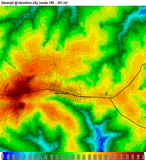
Below is the Elevation map of Naranjal, which displays elevation range with different colors. Scale of the first map is from 198 to 341 m (650 to 1119 ft) with average elevation of 273.4 meters (=897 ft) [note 1]
These maps also provides idea of topography and contour of this city, they are displayed at different zoom levels. More info about maps, scale and edge coordinates you can find below images.
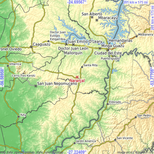
| \ | Map #1 | Topo.Map |
| Scale [m] | 198..341 m | × |
| Scale [ft] | 650..1119 ft | × |
| Average | 273.4 m = 897 ft | × |
| Width | 8.79 km = 5.5 mi | 281.1 km = 174.7 mi |
| Height | 8.79 km = 5.5 mi | 281.1 km = 174.7 mi |
| ↑Max Latitude | -25.927154° | -24.69567° |
| Latitude at center | -25.96667° | -25.96667° |
| ↓Min Latitude | -26.006172° | -27.22409° |
| ← Min Longitude | -55.227275° | -56.58958° |
| Longitude center | -55.18333° | -55.18333° |
| →Max Longitude | -55.139385° | -53.77708° |
Nearby cities:
Cities around Naranjal sort by population:
• Ciudad del Este elevation 186 m
76.6 km,  48°
48°
• Presidente Franco 206 m
72.7 km, 51°
• Santa Rita 292 m
23.5 km,  29°
29°
• Doctor Juan León Mallorquín 247 m
60 km,  353°
353°
• Arquitecto Tomás Romero Pereira 333 m
57.8 km,  186°
186°
• Puerto Mayor Otaño 142 m
68.2 km,  134°
134°
• Yguazú 261 m
59.1 km,  18°
18°
• Abaí 156 m
75.3 km,  264°
264°
• Cedrales 247 m
57.6 km, 53°
• Colonia San Lorenzo 230 m
69.9 km,  146°
146°
• Colonia Carlos Antonio López 256 m
64.2 km,  138°
138°
• General Higinio Morínigo 370 m
73.3 km,  271°
271°
Multilingual:
 En español:
Naranjal elevación 273 m.
 En France:
Naranjal élévation 273 m.
 Auf Deutsch:
Naranjal höhe über dem Meeresspiegel ist 273 m.

Sources and notes:
- [note 1] Map square and city borders are not equal. Map elevation data is calculated only from area inside that square.
- [src 1] Elevation data from geonames database provided with same terms of usage.
- [src 2] The elevation map of Naranjal is generated using elevation data from NASA's 3 arcsec (90m) resolution SRTM data.
- [src 3] Base (background) map © OpenStreetMap contributors tiles are generated by Geofabrik and OpenTopoMap.
Copyright & License:
This Naranjal Elevation Map is licensed under CC BY-SA. You may reuse any part from this page, if you give a proper credit by linking to this URL:
 More info on terms of use page.