Edelira elevation
Edelira (Itapúa), Paraguay elevation is 262 meters and Edelira elevation in feet is 860 ft above sea level [src 1]. Edelira is a populated place (feature code) with elevation that is 88 meters (289 ft) bigger than average city elevation in Paraguay.
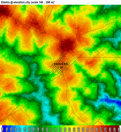
Below is the Elevation map of Edelira, which displays elevation range with different colors. Scale of the first map is from 148 to 296 m (486 to 971 ft) with average elevation of 227.4 meters (=746 ft) [note 1]
These maps also provides idea of topography and contour of this city, they are displayed at different zoom levels. More info about maps, scale and edge coordinates you can find below images.
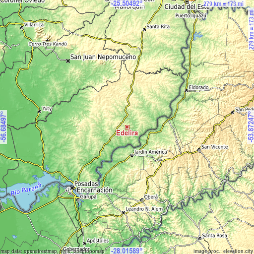
| \ | Map #1 | Topo.Map |
| Scale [m] | 148..296 m | × |
| Scale [ft] | 486..971 ft | × |
| Average | 227.4 m = 746 ft | × |
| Width | 8.73 km = 5.4 mi | 279.2 km = 173.5 mi |
| Height | 8.73 km = 5.4 mi | 279.2 km = 173.5 mi |
| ↑Max Latitude | -26.728097° | -25.50492° |
| Latitude at center | -26.76734° | -26.76734° |
| ↓Min Latitude | -26.806569° | -28.01589° |
| ← Min Longitude | -55.322665° | -56.68497° |
| Longitude center | -55.27872° | -55.27872° |
| →Max Longitude | -55.234775° | -53.87247° |
Nearby cities:
Cities around Edelira sort by population:
• Obligado elevation 188 m
45.9 km,  229°
229°
• Arquitecto Tomás Romero Pereira 333 m
31.7 km,  5°
5°
• Hohenau 202 m
49.6 km, 226°
• Puerto Mayor Otaño 142 m
70.6 km,  54°
54°
• Fram 226 m
64.6 km,  248°
248°
• Trinidad 184 m
63.3 km, 232°
• Jesús 217 m
56 km,  235°
235°
• Bella Vista 145 m
41.4 km,  220°
220°
• Natalio 269 m
14 km,  85°
85°
• Colonia San Lorenzo 230 m
56.5 km,  57°
57°
• Pirapó 153 m
28.2 km, 248°
• Colonia Carlos Antonio López 256 m
66.1 km, 51°
Multilingual:
 En español:
Antidia de Matiauda elevación 262 m.
 En France:
Edelira élévation 262 m.


Sources and notes:
- [note 1] Map square and city borders are not equal. Map elevation data is calculated only from area inside that square.
- [src 1] Elevation data from geonames database provided with same terms of usage.
- [src 2] The elevation map of Edelira is generated using elevation data from NASA's 3 arcsec (90m) resolution SRTM data.
- [src 3] Base (background) map © OpenStreetMap contributors tiles are generated by Geofabrik and OpenTopoMap.
Copyright & License:
This Edelira Elevation Map is licensed under CC BY-SA. You may reuse any part from this page, if you give a proper credit by linking to this URL:
 More info on terms of use page.