General Delgado elevation
General Delgado (Itapúa), Paraguay elevation is 111 meters and General Delgado elevation in feet is 364 ft above sea level [src 1]. General Delgado is a populated place (feature code) with elevation that is 63 meters (207 ft) smaller than average city elevation in Paraguay.
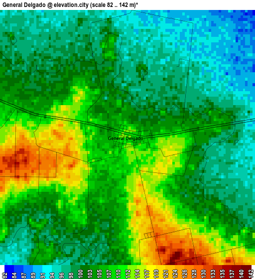
Below is the Elevation map of General Delgado, which displays elevation range with different colors. Scale of the first map is from 82 to 142 m (269 to 466 ft) with average elevation of 104.4 meters (=343 ft) [note 1]
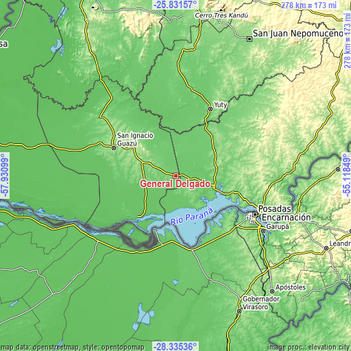
These maps also provides idea of topography and contour of this city, they are displayed at different zoom levels. More info about maps, scale and edge coordinates you can find below images.
| \ | Map #1 | Topo.Map |
| Scale [m] | 82..142 m | × |
| Scale [ft] | 269..466 ft | × |
| Average | 104.4 m = 343 ft | × |
| Width | 8.7 km = 5.4 mi | 278.4 km = 173 mi |
| Height | 8.7 km = 5.4 mi | 278.4 km = 173 mi |
| ↑Max Latitude | -27.051329° | -25.83157° |
| Latitude at center | -27.09046° | -27.09046° |
| ↓Min Latitude | -27.129577° | -28.33536° |
| ← Min Longitude | -56.568685° | -57.93099° |
| Longitude center | -56.52474° | -56.52474° |
| →Max Longitude | -56.480795° | -55.11849° |
Nearby cities:
Cities around General Delgado sort by population:
• Juan de Ayolas elevation 81 m
45.8 km,  224°
224°
• Santa Rosa Misiones 200 m
39.3 km,  305°
305°
• San Pedro del Paraná 147 m
42.7 km,  47°
47°
• Yuty 143 m
59.7 km,  27°
27°
• Carmen del Paraná 100 m
39.6 km,  111°
111°
• General Artigas 139 m
34.6 km,  60°
60°
• Fram 226 m
64.6 km,  79°
79°
• San Cosme y Damián 127 m
31.7 km,  142°
142°
• Santiago 128 m
24.8 km,  256°
256°
• Santa María 122 m
53 km, 310°
• San Patricio 166 m
32 km,  295°
295°
• San Juan del Paraná 116 m
60.1 km, 112°
Multilingual:
 En español:
General Delgado elevación 111 m.
 En France:
General Delgado élévation 111 m.
 Auf Deutsch:
General Delgado höhe über dem Meeresspiegel ist 111 m.

Sources and notes:
- [note 1] Map square and city borders are not equal. Map elevation data is calculated only from area inside that square.
- [src 1] Elevation data from geonames database provided with same terms of usage.
- [src 2] The elevation map of General Delgado is generated using elevation data from NASA's 3 arcsec (90m) resolution SRTM data.
- [src 3] Base (background) map © OpenStreetMap contributors tiles are generated by Geofabrik and OpenTopoMap.
Copyright & License:
This General Delgado Elevation Map is licensed under CC BY-SA. You may reuse any part from this page, if you give a proper credit by linking to this URL:
 More info on terms of use page.