Ybycuí elevation
Ybycuí (Paraguarí, Yvycui), Paraguay elevation is 134 meters and Ybycuí elevation in feet is 440 ft above sea level [src 1]. Ybycuí is a populated place (feature code) with elevation that is 40 meters (131 ft) smaller than average city elevation in Paraguay.
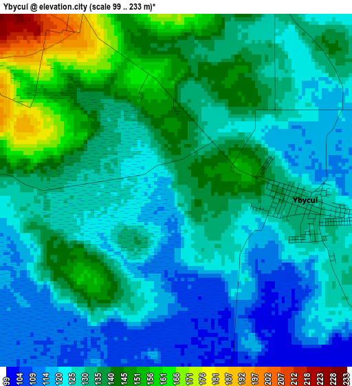
Below is the Elevation map of Ybycuí, which displays elevation range with different colors. Scale of the first map is from 99 to 233 m (325 to 764 ft) with average elevation of 131.7 meters (=432 ft) [note 1]
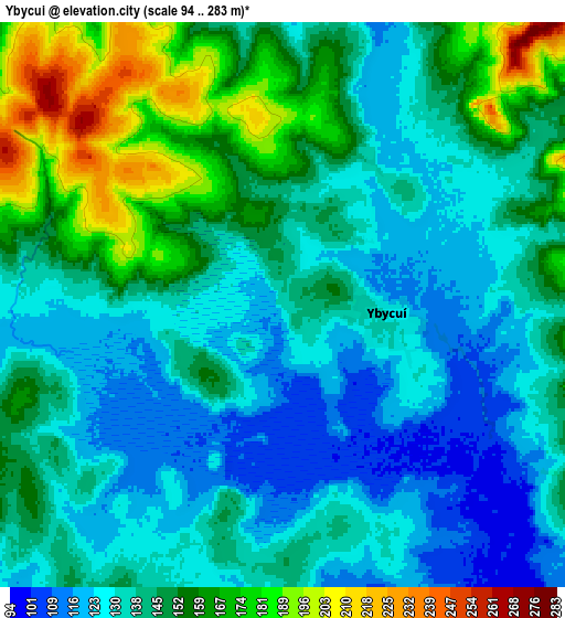
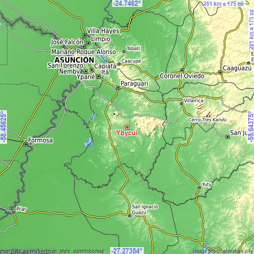
These maps also provides idea of topography and contour of this city, they are displayed at different zoom levels. More info about maps, scale and edge coordinates you can find below images.
| \ | Map #1 | Map #2 | Topo.Map |
| Scale [m] | 99..233 m | 94..283 m | × |
| Scale [ft] | 325..764 ft | 308..928 ft | × |
| Average | 131.7 m = 432 ft | 143.3 m = 470 ft | × |
| Width | 8.78 km = 5.5 mi | 17.56 km = 10.9 mi | 281 km = 174.6 mi |
| Height | 8.78 km = 5.5 mi | 17.56 km = 10.9 mi | 281 km = 174.6 mi |
| ↑Max Latitude | -25.977171° | -25.937659° | -24.7462° |
| Latitude at center | -26.01667° | -26.01667° | -26.01667° |
| ↓Min Latitude | -26.056156° | -26.095628° | -27.27354° |
| ← Min Longitude | -57.093945° | -57.137891° | -58.45625° |
| Longitude center | -57.05° | -57.05° | -57.05° |
| →Max Longitude | -57.006055° | -56.962109° | -55.64375° |
Nearby cities:
Cities around Ybycuí sort by population:
• Paraguarí elevation 134 m
45.1 km,  347°
347°
• Carapeguá 292 m
30.3 km,  322°
322°
• Quiindy 195 m
18.9 km,  283°
283°
• Acahay 155 m
15 km, 318°
• La Colmena 174 m
25.4 km,  55°
55°
• Villa Florida 70 m
42 km,  193°
193°
• Caapucú 138 m
27.7 km,  208°
208°
• Mbuyapey 132 m
36.9 km,  127°
127°
• Sapucaí 171 m
40.1 km,  14°
14°
• Itapé 126 m
47.3 km,  67°
67°
• Coronel Martínez 124 m
52 km, 56°
• San Miguel 96 m
53.7 km,  180°
180°
Multilingual:
 En español:
Ybycuí elevación 134 m.
 En France:
Ybycuí élévation 134 m.


Sources and notes:
- [note 1] Map square and city borders are not equal. Map elevation data is calculated only from area inside that square.
- [src 1] Elevation data from geonames database provided with same terms of usage.
- [src 2] The elevation map of Ybycuí is generated using elevation data from NASA's 3 arcsec (90m) resolution SRTM data.
- [src 3] Base (background) map © OpenStreetMap contributors tiles are generated by Geofabrik and OpenTopoMap.
Copyright & License:
This Ybycuí Elevation Map is licensed under CC BY-SA. You may reuse any part from this page, if you give a proper credit by linking to this URL:
 More info on terms of use page.