Paraguarí elevation
Paraguarí, Paraguay elevation is 134 meters and Paraguarí elevation in feet is 440 ft above sea level [src 1]. Paraguarí is a seat of a first-order administrative division (feature code) with elevation that is 40 meters (131 ft) smaller than average city elevation in Paraguay.
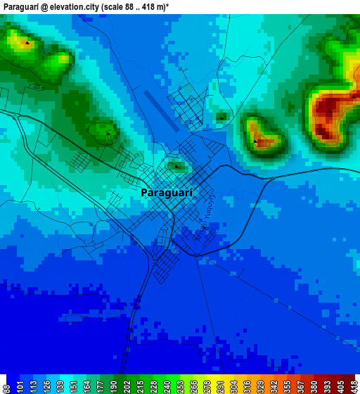
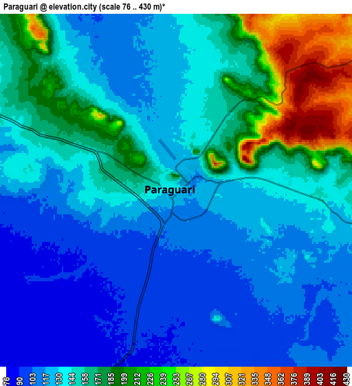
Below is the Elevation map of Paraguarí, which displays elevation range with different colors. Scale of the first map is from 88 to 418 m (289 to 1371 ft) with average elevation of 136.8 meters (=449 ft) [note 1]
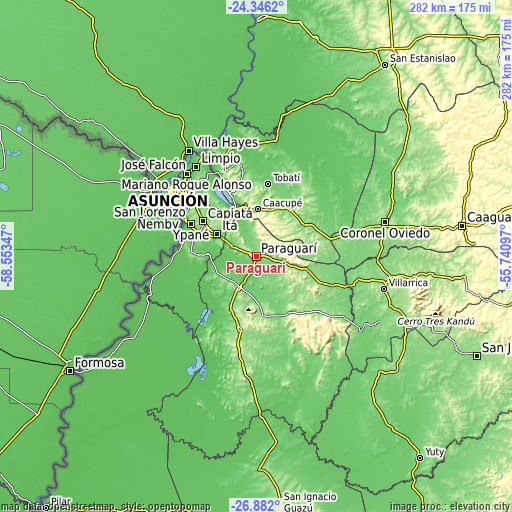
These maps also provides idea of topography and contour of this city, they are displayed at different zoom levels. More info about maps, scale and edge coordinates you can find below images.
| \ | Map #1 | Map #2 | Topo.Map |
| Scale [m] | 88..418 m | 76..430 m | × |
| Scale [ft] | 289..1371 ft | 249..1411 ft | × |
| Average | 136.8 m = 449 ft | 147.8 m = 485 ft | × |
| Width | 8.81 km = 5.5 mi | 17.62 km = 10.9 mi | 282 km = 175.2 mi |
| Height | 8.81 km = 5.5 mi | 17.62 km = 10.9 mi | 282 km = 175.2 mi |
| ↑Max Latitude | -25.581199° | -25.541555° | -24.3462° |
| Latitude at center | -25.62083° | -25.62083° | -25.62083° |
| ↓Min Latitude | -25.660448° | -25.700053° | -26.882° |
| ← Min Longitude | -57.191165° | -57.235111° | -58.55347° |
| Longitude center | -57.14722° | -57.14722° | -57.14722° |
| →Max Longitude | -57.103275° | -57.059329° | -55.74097° |
Nearby cities:
Cities around Paraguarí sort by population:
• Itauguá elevation 140 m
32.8 km,  320°
320°
• Caacupé 180 m
26.1 km,  1°
1°
• Itá 147 m
25.8 km,  301°
301°
• Piribebuy 253 m
20.3 km,  31°
31°
• Ypacarai 91 m
27.6 km,  329°
329°
• Eusebio Ayala 155 m
32.4 km,  35°
35°
• Yaguarón 116 m
15.2 km, 295°
• Carapeguá 292 m
21.7 km,  203°
203°
• Pirayú 110 m
17.6 km, 329°
• Acahay 155 m
32.9 km,  180°
180°
• Nueva Italia 119 m
31.9 km,  272°
272°
• Sapucaí 171 m
20.2 km,  104°
104°
Multilingual:
 En español:
Paraguarí elevación 134 m.
 En France:
Paraguarí élévation 134 m.
 Auf Deutsch:
Paraguarí höhe über dem Meeresspiegel ist 134 m.

Sources and notes:
- [note 1] Map square and city borders are not equal. Map elevation data is calculated only from area inside that square.
- [src 1] Elevation data from geonames database provided with same terms of usage.
- [src 2] The elevation map of Paraguarí is generated using elevation data from NASA's 3 arcsec (90m) resolution SRTM data.
- [src 3] Base (background) map © OpenStreetMap contributors tiles are generated by Geofabrik and OpenTopoMap.
Copyright & License:
This Paraguarí Elevation Map is licensed under CC BY-SA. You may reuse any part from this page, if you give a proper credit by linking to this URL:
 More info on terms of use page.