Valenza elevation
Valenza (Viana do Castelo, Valença), Portugal elevation is 48 meters and Valenza elevation in feet is 157 ft above sea level [src 1]. Valenza is a populated place (feature code) with elevation that is 120 meters (394 ft) smaller than average city elevation in Portugal.
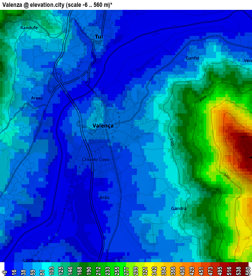
Below is the Elevation map of Valenza, which displays elevation range with different colors. Scale of the first map is from -6 to 560 m (-20 to 1837 ft) with average elevation of 86.4 meters (=283 ft) [note 1]
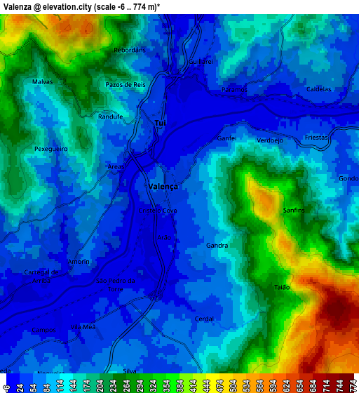
These maps also provides idea of topography and contour of this city, they are displayed at different zoom levels. More info about maps, scale and edge coordinates you can find below images.
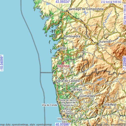
| \ | Map #1 | Map #2 | Topo.Map |
| Scale [m] | -6..560 m | -6..774 m | × |
| Scale [ft] | -20..1837 ft | -20..2539 ft | × |
| Average | 86.4 m = 283 ft | 146.3 m = 480 ft | × |
| Width | 7.26 km = 4.5 mi | 14.52 km = 9 mi | 232.3 km = 144.3 mi |
| Height | 7.26 km = 4.5 mi | 14.52 km = 9 mi | 232.3 km = 144.3 mi |
| ↑Max Latitude | 42.056817° | 42.089437° | 43.06024° |
| Latitude at center | 42.02418° | 42.02418° | 42.02418° |
| ↓Min Latitude | 41.991526° | 41.958856° | 40.97096° |
| ← Min Longitude | -8.678685° | -8.722631° | -10.04099° |
| Longitude center | -8.63474° | -8.63474° | -8.63474° |
| →Max Longitude | -8.590795° | -8.546849° | -7.22849° |
Nearby cities:
Cities around Valenza sort by population:
• Ponte de Lima elevation 13 m
28.9 km,  171°
171°
• Arcos de Valdevez 42 m
26.6 km,  137°
137°
• Monção 34 m
14.1 km,  64°
64°
• Meadela 6 m
37.8 km,  200°
200°
• Mozelos 108 m
26.2 km,  131°
131°
• Vila Praia de Âncora 17 m
29.8 km,  217°
217°
• Areosa 11 m
38.7 km,  208°
208°
• Ponte da Barca 58 m
30.4 km, 143°
• Melgaço 181 m
32.5 km,  72°
72°
• Paredes de Coura 392 m
14.1 km,  154°
154°
• Vila Nova de Cerveira 16 m
12.8 km, 223°
• Valença 56 m
1.2 km,  309°
309°
Multilingual:
 En español:
Valenza elevación 48 m.
 En France:
Valenza élévation 48 m.


Sources and notes:
- [note 1] Map square and city borders are not equal. Map elevation data is calculated only from area inside that square.
- [src 1] Elevation data from geonames database provided with same terms of usage.
- [src 2] The elevation map of Valenza is generated using elevation data from NASA's 3 arcsec (90m) resolution SRTM data.
- [src 3] Base (background) map © OpenStreetMap contributors tiles are generated by Geofabrik and OpenTopoMap.
Copyright & License:
This Valenza Elevation Map is licensed under CC BY-SA. You may reuse any part from this page, if you give a proper credit by linking to this URL:
 More info on terms of use page.