Ponta Garça elevation
Ponta Garça (Azores, Vila Franca do Campo), Portugal elevation is 85 meters and Ponta Garça elevation in feet is 279 ft above sea level [src 1]. Ponta Garça is a populated place (feature code) with elevation that is 83 meters (272 ft) smaller than average city elevation in Portugal.
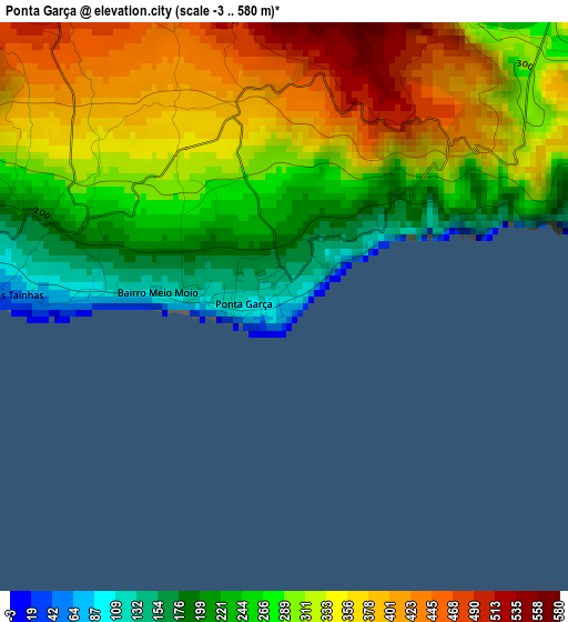
Below is the Elevation map of Ponta Garça, which displays elevation range with different colors. Scale of the first map is from -3 to 580 m (-10 to 1903 ft) with average elevation of 309.9 meters (=1017 ft) [note 1]
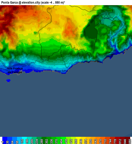
These maps also provides idea of topography and contour of this city, they are displayed at different zoom levels. More info about maps, scale and edge coordinates you can find below images.
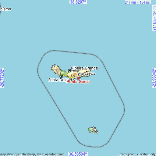
| \ | Map #1 | Map #2 | Topo.Map |
| Scale [m] | -3..580 m | -4..880 m | × |
| Scale [ft] | -10..1903 ft | -13..2887 ft | × |
| Average | 309.9 m = 1017 ft | 404.4 m = 1327 ft | × |
| Width | 7.73 km = 4.8 mi | 15.46 km = 9.6 mi | 247.4 km = 153.7 mi |
| Height | 7.73 km = 4.8 mi | 15.46 km = 9.6 mi | 247.4 km = 153.7 mi |
| ↑Max Latitude | 37.751425° | 37.786163° | 38.8207° |
| Latitude at center | 37.71667° | 37.71667° | 37.71667° |
| ↓Min Latitude | 37.681899° | 37.647112° | 36.59594° |
| ← Min Longitude | -25.410615° | -25.454561° | -26.77292° |
| Longitude center | -25.36667° | -25.36667° | -25.36667° |
| →Max Longitude | -25.322725° | -25.278779° | -23.96042° |
Nearby cities:
Cities around Ponta Garça sort by population:
• Lagoa elevation 41 m
18.3 km,  279°
279°
• Rabo de Peixe 1 m
21.6 km,  298°
298°
• Vila Franca do Campo 26 m
5.9 km,  270°
270°
• Ribeira Grande 4 m
17.9 km,  310°
310°
• Água de Pau 132 m
12.8 km, 272°
• Ribeira Seca 27 m
18.4 km, 307°
• Povoação 81 m
10.9 km,  70°
70°
• Cabouco 184 m
18.4 km,  287°
287°
• Maia 45 m
13 km,  351°
351°
• Furnas 241 m
8.2 km,  37°
37°
• Fenais da Ajuda 2 m
15.4 km,  14°
14°
• Ribeira Seca 134 m
4.5 km, 277°
Multilingual:
 En español:
Ponta Garça elevación 85 m.
 En France:
Ponta Garça élévation 85 m.
 Auf Deutsch:
Ponta Garça höhe über dem Meeresspiegel ist 85 m.

Sources and notes:
- [note 1] Map square and city borders are not equal. Map elevation data is calculated only from area inside that square.
- [src 1] Elevation data from geonames database provided with same terms of usage.
- [src 2] The elevation map of Ponta Garça is generated using elevation data from NASA's 3 arcsec (90m) resolution SRTM data.
- [src 3] Base (background) map © OpenStreetMap contributors tiles are generated by Geofabrik and OpenTopoMap.
Copyright & License:
This Ponta Garça Elevation Map is licensed under CC BY-SA. You may reuse any part from this page, if you give a proper credit by linking to this URL:
 More info on terms of use page.