Castro Daire elevation
Castro Daire (Viseu), Portugal elevation is 571 meters and Castro Daire elevation in feet is 1873 ft above sea level [src 1]. Castro Daire is a seat of a second-order administrative division (feature code) with elevation that is 403 meters (1322 ft) bigger than average city elevation in Portugal.
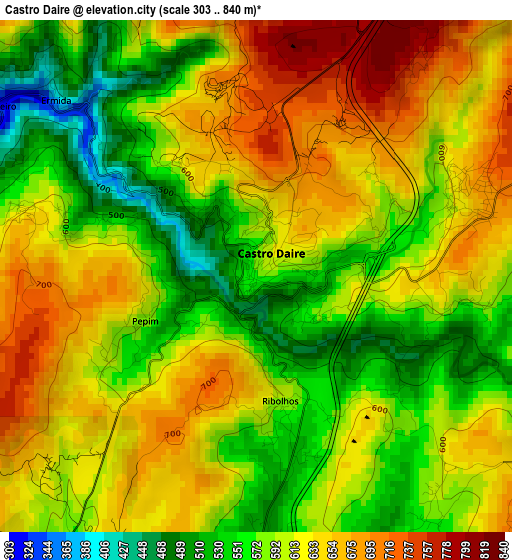
Below is the Elevation map of Castro Daire, which displays elevation range with different colors. Scale of the first map is from 303 to 840 m (994 to 2756 ft) with average elevation of 607.6 meters (=1993 ft) [note 1]
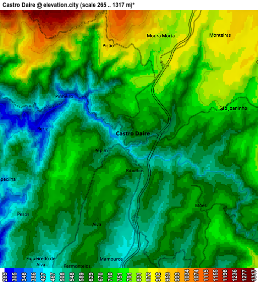
These maps also provides idea of topography and contour of this city, they are displayed at different zoom levels. More info about maps, scale and edge coordinates you can find below images.
| \ | Map #1 | Map #2 | Topo.Map |
| Scale [m] | 303..840 m | 265..1317 m | × |
| Scale [ft] | 994..2756 ft | 869..4321 ft | × |
| Average | 607.6 m = 1993 ft | 668.5 m = 2193 ft | × |
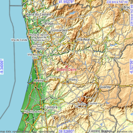
| Width | 7.39 km = 4.6 mi | 14.77 km = 9.2 mi | 236.4 km = 146.9 mi |
| Height | 7.39 km = 4.6 mi | 14.77 km = 9.2 mi | 236.4 km = 146.9 mi |
| ↑Max Latitude | 40.931609° | 40.964801° | 41.95279° |
| Latitude at center | 40.8984° | 40.8984° | 40.8984° |
| ↓Min Latitude | 40.865175° | 40.831933° | 39.82693° |
| ← Min Longitude | -7.977755° | -8.021701° | -9.34006° |
| Longitude center | -7.93381° | -7.93381° | -7.93381° |
| →Max Longitude | -7.889865° | -7.845919° | -6.52756° |
Nearby cities:
Cities around Castro Daire sort by population:
• Lamego elevation 502 m
24.4 km,  25°
25°
• Rio de Loba 489 m
26.3 km,  169°
169°
• Abraveses 512 m
24.2 km,  177°
177°
• Vila Nova de Paiva 800 m
18 km,  106°
106°
• Campo 591 m
20.9 km, 175°
• São Pedro do Sul 210 m
19.7 km,  216°
216°
• Sátão 606 m
24.3 km,  135°
135°
• Tarouca 527 m
18.8 km,  45°
45°
• Resende 232 m
23.2 km,  353°
353°
• Arouca 313 m
26.4 km,  277°
277°
• Vouzela 277 m
24.6 km, 217°
• Cinfães 404 m
23.3 km,  325°
325°
Multilingual:
 En español:
Castro Daire elevación 571 m.
 En France:
Castro Daire élévation 571 m.
 Auf Deutsch:
Castro Daire höhe über dem Meeresspiegel ist 571 m.

Sources and notes:
- [note 1] Map square and city borders are not equal. Map elevation data is calculated only from area inside that square.
- [src 1] Elevation data from geonames database provided with same terms of usage.
- [src 2] The elevation map of Castro Daire is generated using elevation data from NASA's 3 arcsec (90m) resolution SRTM data.
- [src 3] Base (background) map © OpenStreetMap contributors tiles are generated by Geofabrik and OpenTopoMap.
Copyright & License:
This Castro Daire Elevation Map is licensed under CC BY-SA. You may reuse any part from this page, if you give a proper credit by linking to this URL:
 More info on terms of use page.