Guimarães elevation
Guimarães (Braga), Portugal elevation is 189 meters and Guimarães elevation in feet is 620 ft above sea level [src 1]. Guimarães is a seat of a second-order administrative division (feature code) with elevation that is 21 meters (69 ft) bigger than average city elevation in Portugal.
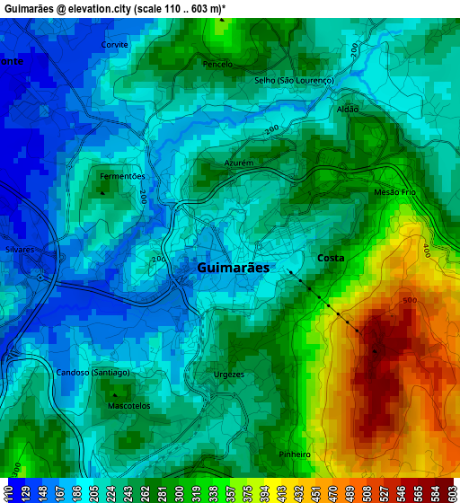
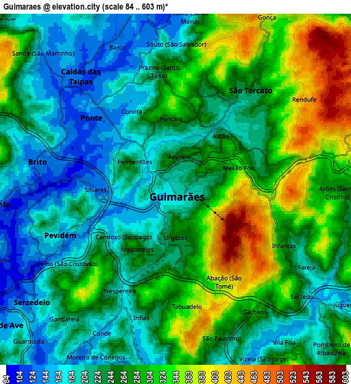
Below is the Elevation map of Guimarães, which displays elevation range with different colors. Scale of the first map is from 110 to 603 m (361 to 1978 ft) with average elevation of 254.7 meters (=836 ft) [note 1]
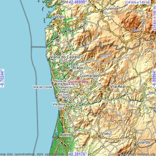
These maps also provides idea of topography and contour of this city, they are displayed at different zoom levels. More info about maps, scale and edge coordinates you can find below images.
| \ | Map #1 | Map #2 | Topo.Map |
| Scale [m] | 110..603 m | 84..603 m | × |
| Scale [ft] | 361..1978 ft | 276..1978 ft | × |
| Average | 254.7 m = 836 ft | 255.3 m = 838 ft | × |
| Width | 7.33 km = 4.6 mi | 14.65 km = 9.1 mi | 234.4 km = 145.6 mi |
| Height | 7.33 km = 4.6 mi | 14.65 km = 9.1 mi | 234.4 km = 145.6 mi |
| ↑Max Latitude | 41.477363° | 41.510279° | 42.48998° |
| Latitude at center | 41.44443° | 41.44443° | 41.44443° |
| ↓Min Latitude | 41.41148° | 41.378514° | 40.38176° |
| ← Min Longitude | -8.340135° | -8.384081° | -9.70244° |
| Longitude center | -8.29619° | -8.29619° | -8.29619° |
| →Max Longitude | -8.252245° | -8.208299° | -6.88994° |
Nearby cities:
Cities around Guimarães sort by population:
• Caldas de Vizela elevation 174 m
7 km,  188°
188°
• Selho 180 m
5 km,  236°
236°
• Serzedo 175 m
7.1 km,  128°
128°
• Ponte 133 m
4 km,  315°
315°
• Caldas das Taipas 131 m
6.2 km, 315°
• Moreira de Conegos 151 m
7.4 km,  209°
209°
• Urgeses 252 m
1.9 km,  184°
184°
• Brito 149 m
5.6 km,  285°
285°
• Ronfe 153 m
7.3 km,  267°
267°
• Arões 367 m
6.9 km,  79°
79°
• Candoso 205 m
2.8 km,  228°
228°
• Vizela 223 m
6.5 km,  155°
155°
Multilingual:
 En español:
Guimarães elevación 189 m.
 En France:
Guimarães élévation 189 m.
 Auf Deutsch:
Guimarães höhe über dem Meeresspiegel ist 189 m.

Sources and notes:
- [note 1] Map square and city borders are not equal. Map elevation data is calculated only from area inside that square.
- [src 1] Elevation data from geonames database provided with same terms of usage.
- [src 2] The elevation map of Guimarães is generated using elevation data from NASA's 3 arcsec (90m) resolution SRTM data.
- [src 3] Base (background) map © OpenStreetMap contributors tiles are generated by Geofabrik and OpenTopoMap.
Copyright & License:
This Guimarães Elevation Map is licensed under CC BY-SA. You may reuse any part from this page, if you give a proper credit by linking to this URL:
 More info on terms of use page.