Alenquer elevation
Alenquer (Lisbon), Portugal elevation is 32 meters and Alenquer elevation in feet is 105 ft above sea level [src 1]. Alenquer is a seat of a second-order administrative division (feature code) with elevation that is 136 meters (446 ft) smaller than average city elevation in Portugal.
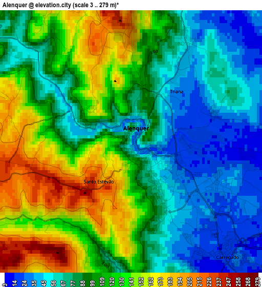
Below is the Elevation map of Alenquer, which displays elevation range with different colors. Scale of the first map is from 3 to 279 m (10 to 915 ft) with average elevation of 101.8 meters (=334 ft) [note 1]
These maps also provides idea of topography and contour of this city, they are displayed at different zoom levels. More info about maps, scale and edge coordinates you can find below images.
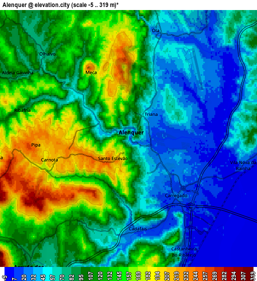
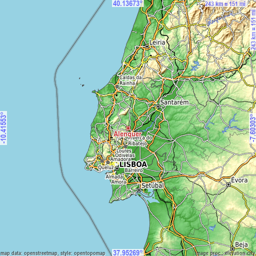
| \ | Map #1 | Map #2 | Topo.Map |
| Scale [m] | 3..279 m | -5..319 m | × |
| Scale [ft] | 10..915 ft | -16..1047 ft | × |
| Average | 101.8 m = 334 ft | 94 m = 308 ft | × |
| Width | 7.59 km = 4.7 mi | 15.18 km = 9.4 mi | 242.8 km = 150.9 mi |
| Height | 7.59 km = 4.7 mi | 15.18 km = 9.4 mi | 242.8 km = 150.9 mi |
| ↑Max Latitude | 39.087268° | 39.12137° | 40.13673° |
| Latitude at center | 39.05315° | 39.05315° | 39.05315° |
| ↓Min Latitude | 39.019016° | 38.984865° | 37.95269° |
| ← Min Longitude | -9.053225° | -9.097171° | -10.41553° |
| Longitude center | -9.00928° | -9.00928° | -9.00928° |
| →Max Longitude | -8.965335° | -8.921389° | -7.60303° |
Nearby cities:
Cities around Alenquer sort by population:
• Vila Franca de Xira elevation 15 m
11 km,  171°
171°
• Carregado 21 m
4.3 km,  139°
139°
• Castanheira do Ribatejo 22 m
7.4 km,  155°
155°
• Azambuja 25 m
12.3 km,  81°
81°
• Arruda dos Vinhos 99 m
9.7 km,  217°
217°
• Ventosa 133 m
10.4 km,  321°
321°
• São João dos Montes 133 m
12.7 km,  183°
183°
• Abrigada 75 m
10.2 km,  355°
355°
• Meca 110 m
3.9 km,  325°
325°
• Cadafais 32 m
5.4 km, 175°
• Ota 42 m
6.7 km,  13°
13°
• Cabanas de Torres 169 m
12.4 km,  336°
336°
Multilingual:
 En español:
Alenquer elevación 32 m.
 En France:
Alenquer élévation 32 m.


Sources and notes:
- [note 1] Map square and city borders are not equal. Map elevation data is calculated only from area inside that square.
- [src 1] Elevation data from geonames database provided with same terms of usage.
- [src 2] The elevation map of Alenquer is generated using elevation data from NASA's 3 arcsec (90m) resolution SRTM data.
- [src 3] Base (background) map © OpenStreetMap contributors tiles are generated by Geofabrik and OpenTopoMap.
Copyright & License:
This Alenquer Elevation Map is licensed under CC BY-SA. You may reuse any part from this page, if you give a proper credit by linking to this URL:
 More info on terms of use page.