Castanheira de Pêra elevation
Castanheira de Pêra (Leiria), Portugal elevation is 478 meters and Castanheira de Pêra elevation in feet is 1568 ft above sea level [src 1]. Castanheira de Pêra is a seat of a second-order administrative division (feature code) with elevation that is 310 meters (1017 ft) bigger than average city elevation in Portugal.
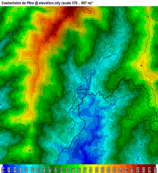
Below is the Elevation map of Castanheira de Pêra, which displays elevation range with different colors. Scale of the first map is from 376 to 997 m (1234 to 3271 ft) with average elevation of 608.1 meters (=1995 ft) [note 1]
These maps also provides idea of topography and contour of this city, they are displayed at different zoom levels. More info about maps, scale and edge coordinates you can find below images.
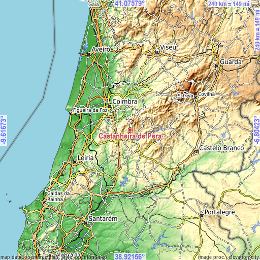
| \ | Map #1 | Topo.Map |
| Scale [m] | 376..997 m | × |
| Scale [ft] | 1234..3271 ft | × |
| Average | 608.1 m = 1995 ft | × |
| Width | 7.49 km = 4.7 mi | 239.5 km = 148.8 mi |
| Height | 7.49 km = 4.7 mi | 239.5 km = 148.8 mi |
| ↑Max Latitude | 40.040822° | 41.07579° |
| Latitude at center | 40.00717° | 40.00717° |
| ↓Min Latitude | 39.973501° | 38.92156° |
| ← Min Longitude | -8.254425° | -9.61673° |
| Longitude center | -8.21048° | -8.21048° |
| →Max Longitude | -8.166535° | -6.80423° |
Nearby cities:
Cities around Castanheira de Pêra sort by population:
• Lousã elevation 150 m
12.6 km,  344°
344°
• Miranda do Corvo 102 m
14.1 km,  312°
312°
• Sertã 262 m
24.8 km,  156°
156°
• Poiares 136 m
22.9 km,  349°
349°
• Assafarge 171 m
25.3 km, 311°
• Pedrógão Grande 400 m
11.3 km,  150°
150°
• Góis 201 m
18.8 km,  27°
27°
• Pampilhosa da Serra 398 m
22.4 km,  78°
78°
• Alvaiázere 311 m
25.1 km,  215°
215°
• Ansião 206 m
21.9 km,  241°
241°
• Penela 164 m
15 km,  281°
281°
• Figueiró dos Vinhos 464 m
12.7 km,  205°
205°
Multilingual:
 En español:
Castanheira de Pêra elevación 478 m.
 En France:
Castanheira de Pêra élévation 478 m.
 Auf Deutsch:
Castanheira de Pêra höhe über dem Meeresspiegel ist 478 m.
 На русском:
Castanheira de Pêra высота над уровнем моря 478 м
Sources and notes:
- [note 1] Map square and city borders are not equal. Map elevation data is calculated only from area inside that square.
- [src 1] Elevation data from geonames database provided with same terms of usage.
- [src 2] The elevation map of Castanheira de Pêra is generated using elevation data from NASA's 3 arcsec (90m) resolution SRTM data.
- [src 3] Base (background) map © OpenStreetMap contributors tiles are generated by Geofabrik and OpenTopoMap.
Copyright & License:
This Castanheira de Pêra Elevation Map is licensed under CC BY-SA. You may reuse any part from this page, if you give a proper credit by linking to this URL:
 More info on terms of use page.