Sobralinho elevation
Sobralinho (Lisbon, Vila Franca de Xira), Portugal elevation is 46 meters and Sobralinho elevation in feet is 151 ft above sea level [src 1]. Sobralinho is a populated place (feature code) with elevation that is 122 meters (400 ft) smaller than average city elevation in Portugal.
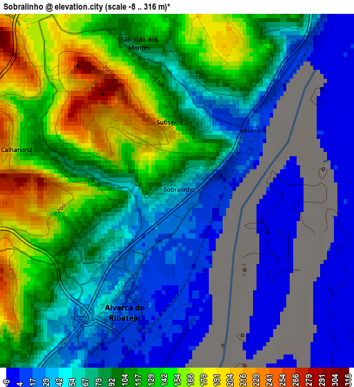
Below is the Elevation map of Sobralinho, which displays elevation range with different colors. Scale of the first map is from -8 to 316 m (-26 to 1037 ft) with average elevation of 90.3 meters (=296 ft) [note 1]
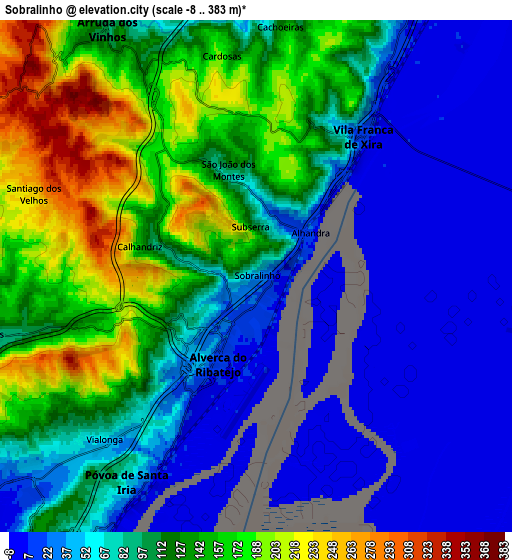
These maps also provides idea of topography and contour of this city, they are displayed at different zoom levels. More info about maps, scale and edge coordinates you can find below images.
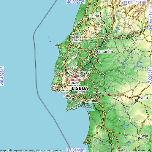
| \ | Map #1 | Map #2 | Topo.Map |
| Scale [m] | -8..316 m | -8..383 m | × |
| Scale [ft] | -26..1037 ft | -26..1257 ft | × |
| Average | 90.3 m = 296 ft | 96 m = 315 ft | × |
| Width | 7.6 km = 4.7 mi | 15.21 km = 9.5 mi | 243.3 km = 151.2 mi |
| Height | 7.6 km = 4.7 mi | 15.21 km = 9.5 mi | 243.3 km = 151.2 mi |
| ↑Max Latitude | 38.951214° | 38.985381° | 40.00272° |
| Latitude at center | 38.91703° | 38.91703° | 38.91703° |
| ↓Min Latitude | 38.88283° | 38.848613° | 37.81448° |
| ← Min Longitude | -9.070505° | -9.114451° | -10.43281° |
| Longitude center | -9.02656° | -9.02656° | -9.02656° |
| →Max Longitude | -8.982615° | -8.938669° | -7.62031° |
Nearby cities:
Cities around Sobralinho sort by population:
• Póvoa de Santa Iria elevation 18 m
7 km,  207°
207°
• São João da Talha 10 m
12 km, 210°
• Santa Iria da Azóia 48 m
10.5 km,  216°
216°
• Vila Franca de Xira 15 m
5.3 km,  36°
36°
• Vialonga 50 m
6.7 km, 221°
• Castanheira do Ribatejo 22 m
9.6 km,  28°
28°
• Alhandra 13 m
1.9 km,  53°
53°
• Arruda dos Vinhos 99 m
8.7 km,  329°
329°
• São João dos Montes 133 m
2.6 km,  14°
14°
• Bucelas 91 m
8.2 km,  258°
258°
• Arranhó 242 m
10.2 km,  293°
293°
• Cadafais 32 m
9.9 km, 11°
Multilingual:
 En español:
Sobralinho elevación 46 m.
 En France:
Sobralinho élévation 46 m.
 Auf Deutsch:
Sobralinho höhe über dem Meeresspiegel ist 46 m.

Sources and notes:
- [note 1] Map square and city borders are not equal. Map elevation data is calculated only from area inside that square.
- [src 1] Elevation data from geonames database provided with same terms of usage.
- [src 2] The elevation map of Sobralinho is generated using elevation data from NASA's 3 arcsec (90m) resolution SRTM data.
- [src 3] Base (background) map © OpenStreetMap contributors tiles are generated by Geofabrik and OpenTopoMap.
Copyright & License:
This Sobralinho Elevation Map is licensed under CC BY-SA. You may reuse any part from this page, if you give a proper credit by linking to this URL:
 More info on terms of use page.