‘Arrābah elevation
‘Arrābah (West Bank), Palestinian Territory elevation is 353 meters and ‘Arrābah elevation in feet is 1158 ft above sea level [src 1]. ‘Arrābah is a populated place (feature code) with elevation that is 114 meters (374 ft) smaller than average city elevation in Palestinian Territory.
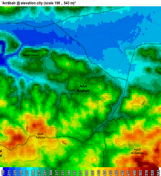
Below is the Elevation map of ‘Arrābah, which displays elevation range with different colors. Scale of the first map is from 198 to 543 m (650 to 1781 ft) with average elevation of 318.4 meters (=1045 ft) [note 1]
These maps also provides idea of topography and contour of this city, they are displayed at different zoom levels. More info about maps, scale and edge coordinates you can find below images.
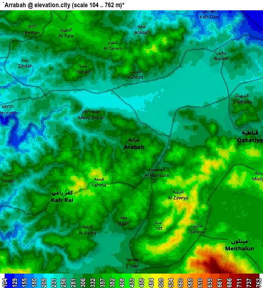
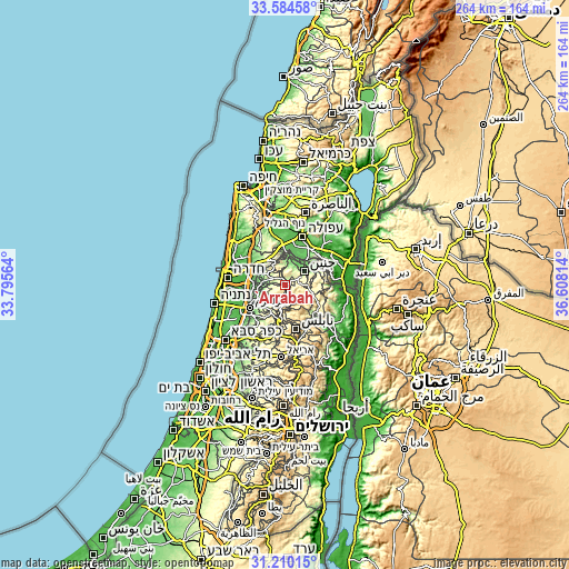
| \ | Map #1 | Map #2 | Topo.Map |
| Scale [m] | 198..543 m | 104..762 m | × |
| Scale [ft] | 650..1781 ft | 341..2500 ft | × |
| Average | 318.4 m = 1045 ft | 315.9 m = 1036 ft | × |
| Width | 8.25 km = 5.1 mi | 16.5 km = 10.3 mi | 264 km = 164 mi |
| Height | 8.25 km = 5.1 mi | 16.5 km = 10.3 mi | 264 km = 164 mi |
| ↑Max Latitude | 32.442265° | 32.479344° | 33.58458° |
| Latitude at center | 32.40517° | 32.40517° | 32.40517° |
| ↓Min Latitude | 32.36806° | 32.330935° | 31.21015° |
| ← Min Longitude | 35.157945° | 35.113999° | 33.79564° |
| Longitude center | 35.20189° | 35.20189° | 35.20189° |
| →Max Longitude | 35.245835° | 35.289781° | 36.60814° |
Nearby cities:
Cities around ‘Arrābah sort by population:
• Ya‘bad elevation 351 m
5.5 km,  324°
324°
• Kafr Rā‘ī 399 m
5.6 km,  232°
232°
• ‘Ajjah 422 m
5 km,  186°
186°
• Şānūr 386 m
6.8 km,  143°
143°
• Kufayrit 353 m
4.3 km,  359°
359°
• Faḩmah 438 m
3.3 km,  220°
220°
• ‘Anzah 417 m
5.4 km,  161°
161°
• Ash Shuhadā’ 301 m
7 km,  67°
67°
• Mirkah 369 m
3.6 km,  107°
107°
• Bīr al Bāshā 268 m
3.1 km,  57°
57°
• Kafr Qūd 314 m
6.2 km,  21°
21°
• Al Hāshimīyah 360 m
6.7 km,  14°
14°
Multilingual:
 En español:
‘Arrābah elevación 353 m.
 En France:
‘Arrābah élévation 353 m.
 Auf Deutsch:
‘Arrābah höhe über dem Meeresspiegel ist 353 m.

Sources and notes:
- [note 1] Map square and city borders are not equal. Map elevation data is calculated only from area inside that square.
- [src 1] Elevation data from geonames database provided with same terms of usage.
- [src 2] The elevation map of ‘Arrābah is generated using elevation data from NASA's 3 arcsec (90m) resolution SRTM data.
- [src 3] Base (background) map © OpenStreetMap contributors tiles are generated by Geofabrik and OpenTopoMap.
Copyright & License:
This ‘Arrābah Elevation Map is licensed under CC BY-SA. You may reuse any part from this page, if you give a proper credit by linking to this URL:
 More info on terms of use page.