Jannātah elevation
Jannātah (West Bank, Bethlehem), Palestinian Territory elevation is 599 meters and Jannātah elevation in feet is 1965 ft above sea level [src 1]. Jannātah is a populated place (feature code) with elevation that is 132 meters (433 ft) bigger than average city elevation in Palestinian Territory.
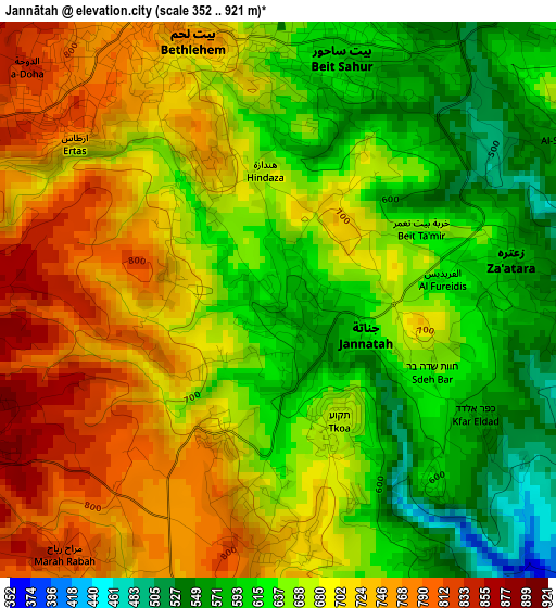
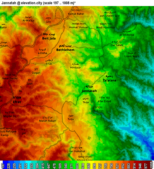
Below is the Elevation map of Jannātah, which displays elevation range with different colors. Scale of the first map is from 352 to 921 m (1155 to 3022 ft) with average elevation of 671.2 meters (=2202 ft) [note 1]
These maps also provides idea of topography and contour of this city, they are displayed at different zoom levels. More info about maps, scale and edge coordinates you can find below images.
| \ | Map #1 | Map #2 | Topo.Map |
| Scale [m] | 352..921 m | 197..1008 m | × |
| Scale [ft] | 1155..3022 ft | 646..3307 ft | × |
| Average | 671.2 m = 2202 ft | 664.5 m = 2180 ft | × |
| Width | 8.32 km = 5.2 mi | 16.63 km = 10.3 mi | 266.1 km = 165.3 mi |
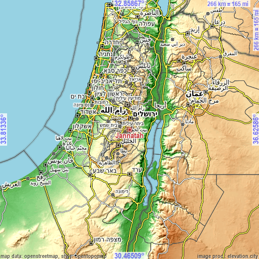
| Height | 8.32 km = 5.2 mi | 16.63 km = 10.3 mi | 266.1 km = 165.3 mi |
| ↑Max Latitude | 31.706984° | 31.744363° | 32.85867° |
| Latitude at center | 31.66959° | 31.66959° | 31.66959° |
| ↓Min Latitude | 31.632181° | 31.594757° | 30.46509° |
| ← Min Longitude | 35.175665° | 35.131719° | 33.81336° |
| Longitude center | 35.21961° | 35.21961° | 35.21961° |
| →Max Longitude | 35.263555° | 35.307501° | 36.62586° |
Nearby cities:
Cities around Jannātah sort by population:
• Bethlehem elevation 775 m
4.2 km,  339°
339°
• Bayt Jālā 792 m
5.9 km,  329°
329°
• Bayt Sāḩūr 609 m
3.5 km,  10°
10°
• Ad Dawḩah 838 m
5 km,  311°
311°
• Al Khaḑir 828 m
5.7 km,  298°
298°
• Za‘tarah 570 m
3.5 km,  82°
82°
• Arţās 708 m
3.8 km, 305°
• Jūrat ash Sham‘ah 918 m
5.2 km,  245°
245°
• Wādī Raḩḩāl 911 m
5 km,  264°
264°
• Khallat an Nu‘mān 621 m
5.7 km,  21°
21°
• Marāḩ Rabbāḩ 820 m
5 km,  218°
218°
• Bayt Ta‘mar 650 m
2.2 km,  60°
60°
Multilingual:
 En español:
Jannātah elevación 599 m.
 En France:
Jannātah élévation 599 m.
 Auf Deutsch:
Jannātah höhe über dem Meeresspiegel ist 599 m.

Sources and notes:
- [note 1] Map square and city borders are not equal. Map elevation data is calculated only from area inside that square.
- [src 1] Elevation data from geonames database provided with same terms of usage.
- [src 2] The elevation map of Jannātah is generated using elevation data from NASA's 3 arcsec (90m) resolution SRTM data.
- [src 3] Base (background) map © OpenStreetMap contributors tiles are generated by Geofabrik and OpenTopoMap.
Copyright & License:
This Jannātah Elevation Map is licensed under CC BY-SA. You may reuse any part from this page, if you give a proper credit by linking to this URL:
 More info on terms of use page.