Ni‘līn elevation
Ni‘līn (West Bank), Palestinian Territory elevation is 239 meters and Ni‘līn elevation in feet is 784 ft above sea level [src 1]. Ni‘līn is a populated place (feature code) with elevation that is 228 meters (748 ft) smaller than average city elevation in Palestinian Territory.
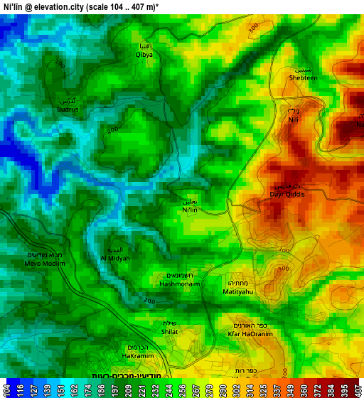
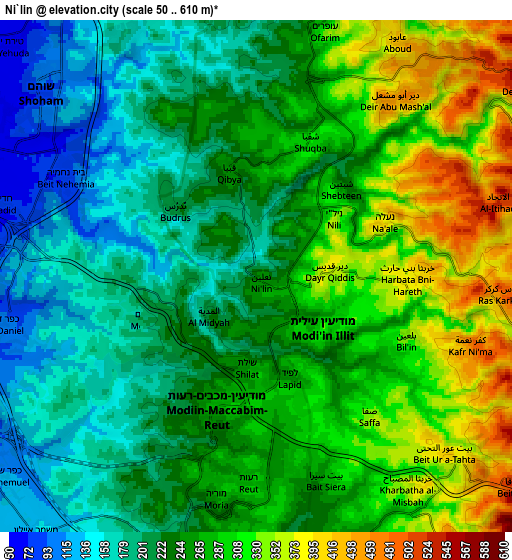
Below is the Elevation map of Ni‘līn, which displays elevation range with different colors. Scale of the first map is from 104 to 407 m (341 to 1335 ft) with average elevation of 238.6 meters (=783 ft) [note 1]
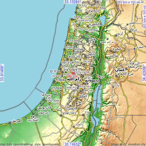
These maps also provides idea of topography and contour of this city, they are displayed at different zoom levels. More info about maps, scale and edge coordinates you can find below images.
| \ | Map #1 | Map #2 | Topo.Map |
| Scale [m] | 104..407 m | 50..610 m | × |
| Scale [ft] | 341..1335 ft | 164..2001 ft | × |
| Average | 238.6 m = 783 ft | 254.6 m = 835 ft | × |
| Width | 8.29 km = 5.2 mi | 16.58 km = 10.3 mi | 265.3 km = 164.8 mi |
| Height | 8.29 km = 5.2 mi | 16.58 km = 10.3 mi | 265.3 km = 164.8 mi |
| ↑Max Latitude | 31.984742° | 32.022008° | 33.13291° |
| Latitude at center | 31.94746° | 31.94746° | 31.94746° |
| ↓Min Latitude | 31.910163° | 31.872852° | 30.74652° |
| ← Min Longitude | 34.976365° | 34.932419° | 33.61406° |
| Longitude center | 35.02031° | 35.02031° | 35.02031° |
| →Max Longitude | 35.064255° | 35.108201° | 36.42656° |
Nearby cities:
Cities around Ni‘līn sort by population:
• Qibyah elevation 256 m
3.5 km,  343°
343°
• Bayt ‘Ūr at Taḩtā 388 m
8.1 km,  134°
134°
• Shuqbā 309 m
4.8 km,  23°
23°
• Şaffā 354 m
6 km,  140°
140°
• Dayr Abū Mash‘al 444 m
7.3 km,  38°
38°
• Kharbathā Banī Ḩārith 391 m
4.9 km,  93°
93°
• Bayt Sīrā 277 m
7.1 km,  159°
159°
• Dayr Qiddīs 375 m
2.3 km, 86°
• Bil‘īn 337 m
5.3 km,  113°
113°
• Rās Karkar 479 m
8.3 km, 93°
• Budrus 224 m
3.3 km,  311°
311°
• Al Midyah 225 m
1.9 km,  228°
228°
Multilingual:
 En español:
Ni‘līn elevación 239 m.
 En France:
Ni‘līn élévation 239 m.


Sources and notes:
- [note 1] Map square and city borders are not equal. Map elevation data is calculated only from area inside that square.
- [src 1] Elevation data from geonames database provided with same terms of usage.
- [src 2] The elevation map of Ni‘līn is generated using elevation data from NASA's 3 arcsec (90m) resolution SRTM data.
- [src 3] Base (background) map © OpenStreetMap contributors tiles are generated by Geofabrik and OpenTopoMap.
Copyright & License:
This Ni‘līn Elevation Map is licensed under CC BY-SA. You may reuse any part from this page, if you give a proper credit by linking to this URL:
 More info on terms of use page.