Sīlat al Ḩārithīyah elevation
Sīlat al Ḩārithīyah (West Bank, Jenin), Palestinian Territory elevation is 128 meters and Sīlat al Ḩārithīyah elevation in feet is 420 ft above sea level [src 1]. Sīlat al Ḩārithīyah is a populated place (feature code) with elevation that is 339 meters (1112 ft) smaller than average city elevation in Palestinian Territory.
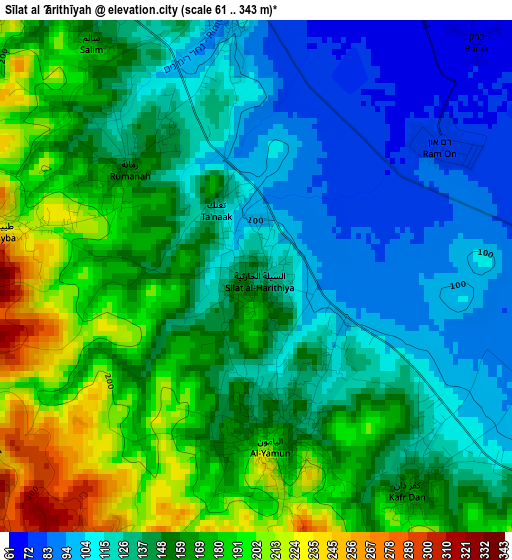
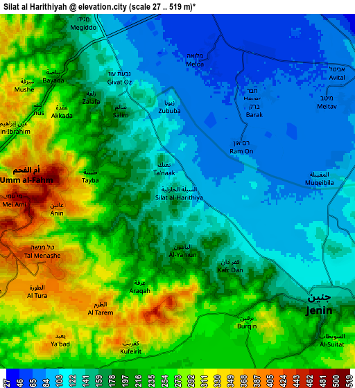
Below is the Elevation map of Sīlat al Ḩārithīyah, which displays elevation range with different colors. Scale of the first map is from 61 to 343 m (200 to 1125 ft) with average elevation of 146.9 meters (=482 ft) [note 1]
These maps also provides idea of topography and contour of this city, they are displayed at different zoom levels. More info about maps, scale and edge coordinates you can find below images.
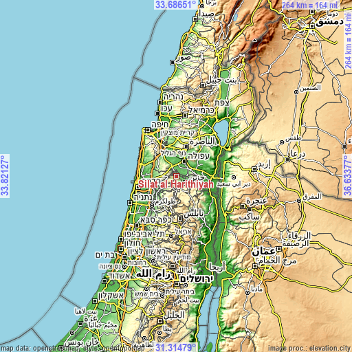
| \ | Map #1 | Map #2 | Topo.Map |
| Scale [m] | 61..343 m | 27..519 m | × |
| Scale [ft] | 200..1125 ft | 89..1703 ft | × |
| Average | 146.9 m = 482 ft | 190.2 m = 624 ft | × |
| Width | 8.24 km = 5.1 mi | 16.48 km = 10.2 mi | 263.7 km = 163.9 mi |
| Height | 8.24 km = 5.1 mi | 16.48 km = 10.2 mi | 263.7 km = 163.9 mi |
| ↑Max Latitude | 32.545522° | 32.582559° | 33.68651° |
| Latitude at center | 32.50847° | 32.50847° | 32.50847° |
| ↓Min Latitude | 32.471403° | 32.43432° | 31.31479° |
| ← Min Longitude | 35.183575° | 35.139629° | 33.82127° |
| Longitude center | 35.22752° | 35.22752° | 35.22752° |
| →Max Longitude | 35.271465° | 35.315411° | 36.63377° |
Nearby cities:
Cities around Sīlat al Ḩārithīyah sort by population:
• Al Yāmūn elevation 177 m
2.6 km,  174°
174°
• Birqīn 259 m
6.8 km,  152°
152°
• Kafr Dān 157 m
4.2 km,  143°
143°
• ‘Anīn 427 m
5.7 km,  263°
263°
• Rummanah 157 m
2.8 km,  309°
309°
• Kufayrit 353 m
7.6 km,  198°
198°
• Al ‘Araqa 288 m
4.9 km,  211°
211°
• Aţ Ţaybah 233 m
4 km,  280°
280°
• Zubūbah 103 m
3.9 km,  353°
353°
• Al Jalamah 120 m
8 km,  90°
90°
• Kafr Qūd 314 m
5.8 km,  180°
180°
• Al Hāshimīyah 360 m
5 km,  188°
188°
Multilingual:
 En español:
Sīlat al Ḩārithīyah elevación 128 m.
 En France:
Sīlat al Ḩārithīyah élévation 128 m.
 Auf Deutsch:
Sīlat al Ḩārithīyah höhe über dem Meeresspiegel ist 128 m.
 На русском:
Sīlat al Ḩārithīyah высота над уровнем моря 128 м
Sources and notes:
- [note 1] Map square and city borders are not equal. Map elevation data is calculated only from area inside that square.
- [src 1] Elevation data from geonames database provided with same terms of usage.
- [src 2] The elevation map of Sīlat al Ḩārithīyah is generated using elevation data from NASA's 3 arcsec (90m) resolution SRTM data.
- [src 3] Base (background) map © OpenStreetMap contributors tiles are generated by Geofabrik and OpenTopoMap.
Copyright & License:
This Sīlat al Ḩārithīyah Elevation Map is licensed under CC BY-SA. You may reuse any part from this page, if you give a proper credit by linking to this URL:
 More info on terms of use page.