Al Mughrāqah elevation
Al Mughrāqah (Gaza Strip, Gaza), Palestinian Territory elevation is 14 meters and Al Mughrāqah elevation in feet is 46 ft above sea level [src 1]. Al Mughrāqah is a populated place (feature code) with elevation that is 453 meters (1486 ft) smaller than average city elevation in Palestinian Territory.
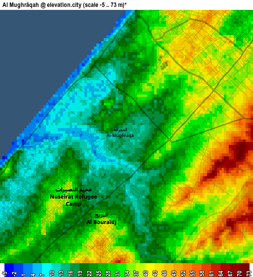
Below is the Elevation map of Al Mughrāqah, which displays elevation range with different colors. Scale of the first map is from -5 to 73 m (-16 to 240 ft) with average elevation of 28.3 meters (=93 ft) [note 1]
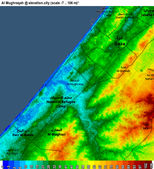
These maps also provides idea of topography and contour of this city, they are displayed at different zoom levels. More info about maps, scale and edge coordinates you can find below images.
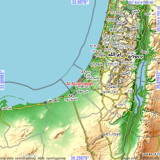
| \ | Map #1 | Map #2 | Topo.Map |
| Scale [m] | -5..73 m | -7..106 m | × |
| Scale [ft] | -16..240 ft | -23..348 ft | × |
| Average | 28.3 m = 93 ft | 42.1 m = 138 ft | × |
| Width | 8.34 km = 5.2 mi | 16.67 km = 10.4 mi | 266.7 km = 165.7 mi |
| Height | 8.34 km = 5.2 mi | 16.67 km = 10.4 mi | 266.7 km = 165.7 mi |
| ↑Max Latitude | 31.503346° | 31.540806° | 32.6576° |
| Latitude at center | 31.46587° | 31.46587° | 31.46587° |
| ↓Min Latitude | 31.428379° | 31.390874° | 30.25878° |
| ← Min Longitude | 34.368135° | 34.324189° | 33.00583° |
| Longitude center | 34.41208° | 34.41208° | 34.41208° |
| →Max Longitude | 34.456025° | 34.499971° | 35.81833° |
Nearby cities:
Cities around Al Mughrāqah sort by population:
• Gaza elevation 38 m
6.5 km,  52°
52°
• Jabālyā 43 m
9.6 km,  44°
44°
• Dayr al Balaḩ 19 m
7.9 km,  227°
227°
• Bayt Lāhyā 33 m
11.9 km, 41°
• Bayt Ḩānūn 55 m
14 km,  56°
56°
• An Nuşayrāt 33 m
2.7 km,  224°
224°
• Al Burayj 40 m
3.1 km,  196°
196°
• Al Qarārah 40 m
12.3 km,  213°
213°
• Az Zuwāydah 34 m
4.2 km, 225°
• Wādī as Salqā 30 m
10.1 km, 224°
• Juḩr ad Dīk 48 m
2.6 km,  115°
115°
• Al Muşaddar 42 m
7 km, 207°
Multilingual:
 En español:
Al Mughrāqah elevación 14 m.
 En France:
Al Mughrāqah élévation 14 m.
 Auf Deutsch:
Al Mughrāqah höhe über dem Meeresspiegel ist 14 m.

Sources and notes:
- [note 1] Map square and city borders are not equal. Map elevation data is calculated only from area inside that square.
- [src 1] Elevation data from geonames database provided with same terms of usage.
- [src 2] The elevation map of Al Mughrāqah is generated using elevation data from NASA's 3 arcsec (90m) resolution SRTM data.
- [src 3] Base (background) map © OpenStreetMap contributors tiles are generated by Geofabrik and OpenTopoMap.
Copyright & License:
This Al Mughrāqah Elevation Map is licensed under CC BY-SA. You may reuse any part from this page, if you give a proper credit by linking to this URL:
 More info on terms of use page.