Santa Barbara elevation
Santa Barbara (Canóvanas, Torrecilla Alta Barrio), Puerto Rico elevation is 18 meters and Santa Barbara elevation in feet is 59 ft above sea level [src 1]. Santa Barbara is a populated place (feature code) with elevation that is 82 meters (269 ft) smaller than average city elevation in Puerto Rico.
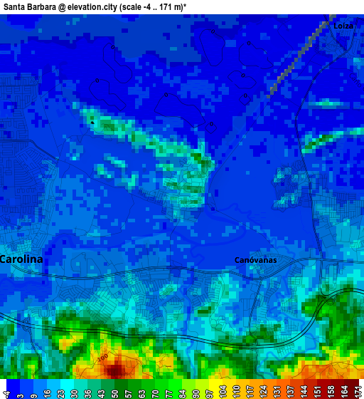
Below is the Elevation map of Santa Barbara, which displays elevation range with different colors. Scale of the first map is from -4 to 171 m (-13 to 561 ft) with average elevation of 17.5 meters (=57 ft) [note 1]
These maps also provides idea of topography and contour of this city, they are displayed at different zoom levels. More info about maps, scale and edge coordinates you can find below images.
| \ | Map #1 | Map #2 | Topo.Map |
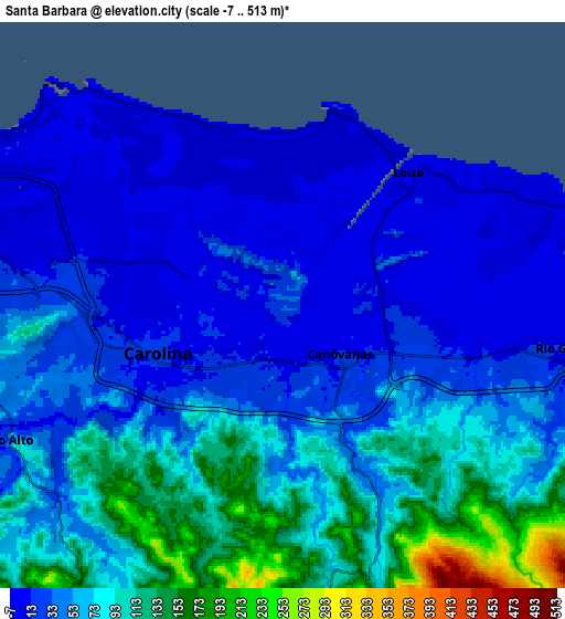
| Scale [m] | -4..171 m | -7..513 m | × |
| Scale [ft] | -13..561 ft | -23..1683 ft | × |
| Average | 17.5 m = 57 ft | 58.2 m = 191 ft | × |
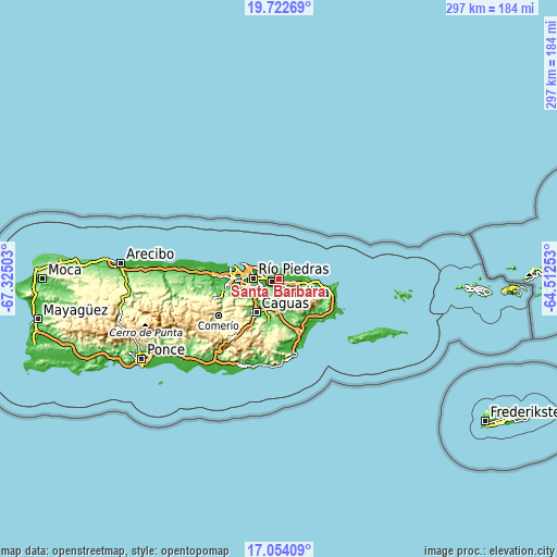
| Width | 9.27 km = 5.8 mi | 18.55 km = 11.5 mi | 296.7 km = 184.4 mi |
| Height | 9.27 km = 5.8 mi | 18.55 km = 11.5 mi | 296.7 km = 184.4 mi |
| ↑Max Latitude | 18.435255° | 18.47694° | 19.72269° |
| Latitude at center | 18.39356° | 18.39356° | 18.39356° |
| ↓Min Latitude | 18.351855° | 18.310139° | 17.05409° |
| ← Min Longitude | -65.962725° | -66.006671° | -67.32503° |
| Longitude center | -65.91878° | -65.91878° | -65.91878° |
| →Max Longitude | -65.874835° | -65.830889° | -64.51253° |
Nearby cities:
Cities around Santa Barbara sort by population:
• Carolina elevation 22 m
4.3 km,  250°
250°
• Trujillo Alto 21 m
10.3 km, 245°
• Río Grande 16 m
9.4 km,  99°
99°
• Canovanas 15 m
2.9 km,  135°
135°
• San Isidro 12 m
3.5 km,  92°
92°
• Vieques 4 m
9.7 km,  68°
68°
• Loíza 4 m
5.9 km,  44°
44°
• La Dolores 19 m
7 km,  106°
106°
• Campo Rico 161 m
6.6 km,  160°
160°
• Suárez 3 m
8 km,  59°
59°
• Benitez 400 m
14 km, 162°
• Bartolo 60 m
9.2 km, 112°
Multilingual:
 En español:
Santa Barbara elevación 18 m.
 En France:
Santa Barbara élévation 18 m.
 Auf Deutsch:
Santa Barbara höhe über dem Meeresspiegel ist 18 m.

Sources and notes:
- [note 1] Map square and city borders are not equal. Map elevation data is calculated only from area inside that square.
- [src 1] Elevation data from geonames database provided with same terms of usage.
- [src 2] The elevation map of Santa Barbara is generated using elevation data from NASA's 3 arcsec (90m) resolution SRTM data.
- [src 3] Base (background) map © OpenStreetMap contributors tiles are generated by Geofabrik and OpenTopoMap.
Copyright & License:
This Santa Barbara Elevation Map is licensed under CC BY-SA. You may reuse any part from this page, if you give a proper credit by linking to this URL:
 More info on terms of use page.