Playita elevation
Playita (Yabucoa, Calabazas Barrio), Puerto Rico elevation is 28 meters and Playita elevation in feet is 92 ft above sea level [src 1]. Playita is a populated place (feature code) with elevation that is 72 meters (236 ft) smaller than average city elevation in Puerto Rico.
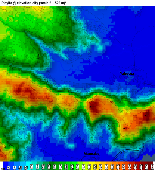
Below is the Elevation map of Playita, which displays elevation range with different colors. Scale of the first map is from 2 to 522 m (7 to 1713 ft) with average elevation of 137.8 meters (=452 ft) [note 1]
These maps also provides idea of topography and contour of this city, they are displayed at different zoom levels. More info about maps, scale and edge coordinates you can find below images.
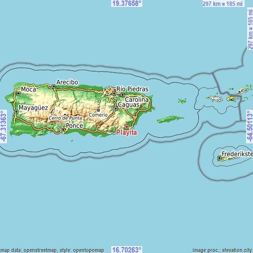
| \ | Map #1 | Topo.Map |
| Scale [m] | 2..522 m | × |
| Scale [ft] | 7..1713 ft | × |
| Average | 137.8 m = 452 ft | × |
| Width | 9.29 km = 5.8 mi | 297.3 km = 184.7 mi |
| Height | 9.29 km = 5.8 mi | 297.3 km = 184.7 mi |
| ↑Max Latitude | 18.086469° | 19.37658° |
| Latitude at center | 18.04469° | 18.04469° |
| ↓Min Latitude | 18.002901° | 16.70263° |
| ← Min Longitude | -65.951325° | -67.31363° |
| Longitude center | -65.90738° | -65.90738° |
| →Max Longitude | -65.863435° | -64.50113° |
Nearby cities:
Cities around Playita sort by population:
• Yabucoa elevation 27 m
3 km,  77°
77°
• Patillas 21 m
12.2 km,  249°
249°
• Emajagua 22 m
5.6 km,  151°
151°
• Martorell 27 m
3.6 km,  15°
15°
• Palmas 68 m
14 km,  242°
242°
• Maunabo 13 m
4.3 km,  168°
168°
• Comunas 49 m
8.2 km,  54°
54°
• El Negro 41 m
6 km,  97°
97°
• Candelero Arriba 73 m
9.8 km, 49°
• Rosa Sanchez 30 m
2 km,  341°
341°
• Palo Seco 77 m
5.2 km,  216°
216°
• Lamboglia 35 m
10.9 km,  229°
229°
Multilingual:
 En español:
Playita elevación 28 m.
 En France:
Playita élévation 28 m.


Sources and notes:
- [note 1] Map square and city borders are not equal. Map elevation data is calculated only from area inside that square.
- [src 1] Elevation data from geonames database provided with same terms of usage.
- [src 2] The elevation map of Playita is generated using elevation data from NASA's 3 arcsec (90m) resolution SRTM data.
- [src 3] Base (background) map © OpenStreetMap contributors tiles are generated by Geofabrik and OpenTopoMap.
Copyright & License:
This Playita Elevation Map is licensed under CC BY-SA. You may reuse any part from this page, if you give a proper credit by linking to this URL:
 More info on terms of use page.