Luquillo elevation
Luquillo, Puerto Rico elevation is 12 meters and Luquillo elevation in feet is 39 ft above sea level [src 1]. Luquillo is a seat of a first-order administrative division (feature code) with elevation that is 88 meters (289 ft) smaller than average city elevation in Puerto Rico.
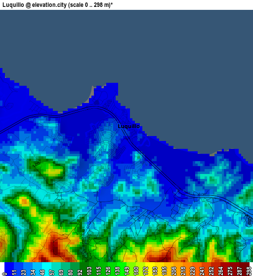
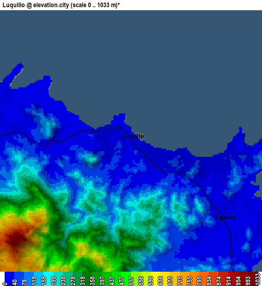
Below is the Elevation map of Luquillo, which displays elevation range with different colors. Scale of the first map is from 0 to 298 m (0 to 978 ft) with average elevation of 60.1 meters (=197 ft) [note 1]
These maps also provides idea of topography and contour of this city, they are displayed at different zoom levels. More info about maps, scale and edge coordinates you can find below images.
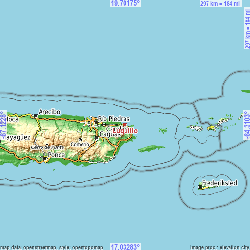
| \ | Map #1 | Map #2 | Topo.Map |
| Scale [m] | 0..298 m | 0..1033 m | × |
| Scale [ft] | 0..978 ft | 0..3389 ft | × |
| Average | 60.1 m = 197 ft | 163.7 m = 537 ft | × |
| Width | 9.27 km = 5.8 mi | 18.55 km = 11.5 mi | 296.8 km = 184.4 mi |
| Height | 9.27 km = 5.8 mi | 18.55 km = 11.5 mi | 296.8 km = 184.4 mi |
| ↑Max Latitude | 18.41415° | 18.45584° | 19.70175° |
| Latitude at center | 18.37245° | 18.37245° | 18.37245° |
| ↓Min Latitude | 18.33074° | 18.289019° | 17.03283° |
| ← Min Longitude | -65.760495° | -65.804441° | -67.1228° |
| Longitude center | -65.71655° | -65.71655° | -65.71655° |
| →Max Longitude | -65.672605° | -65.628659° | -64.3103° |
Nearby cities:
Cities around Luquillo sort by population:
• Fajardo elevation 16 m
8.5 km,  127°
127°
• Río Grande 16 m
12.1 km,  274°
274°
• Ceiba 24 m
14 km,  149°
149°
• Vieques 4 m
13.6 km,  295°
295°
• La Dolores 19 m
14.7 km, 271°
• Aguas Claras 34 m
14.9 km, 153°
• Luis M. Cintron 27 m
11.5 km, 134°
• Hato Candal 40 m
7.4 km, 271°
• Playa Fortuna 7 m
3.1 km,  284°
284°
• Ramos 51 m
3.7 km,  173°
173°
• Bartolo 60 m
12.9 km,  264°
264°
• Palmer 19 m
6.1 km, 267°
Multilingual:
 En español:
Luquillo elevación 12 m.
 En France:
Luquillo élévation 12 m.


Sources and notes:
- [note 1] Map square and city borders are not equal. Map elevation data is calculated only from area inside that square.
- [src 1] Elevation data from geonames database provided with same terms of usage.
- [src 2] The elevation map of Luquillo is generated using elevation data from NASA's 3 arcsec (90m) resolution SRTM data.
- [src 3] Base (background) map © OpenStreetMap contributors tiles are generated by Geofabrik and OpenTopoMap.
Copyright & License:
This Luquillo Elevation Map is licensed under CC BY-SA. You may reuse any part from this page, if you give a proper credit by linking to this URL:
 More info on terms of use page.