Guánica elevation
Guánica, Puerto Rico elevation is 7 meters and Guánica elevation in feet is 23 ft above sea level [src 1]. Guánica is a seat of a first-order administrative division (feature code) with elevation that is 93 meters (305 ft) smaller than average city elevation in Puerto Rico.
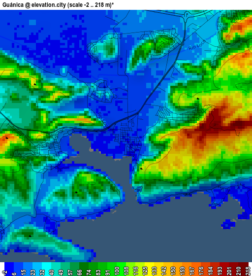
Below is the Elevation map of Guánica, which displays elevation range with different colors. Scale of the first map is from -2 to 218 m (-7 to 715 ft) with average elevation of 52.4 meters (=172 ft) [note 1]
These maps also provides idea of topography and contour of this city, they are displayed at different zoom levels. More info about maps, scale and edge coordinates you can find below images.
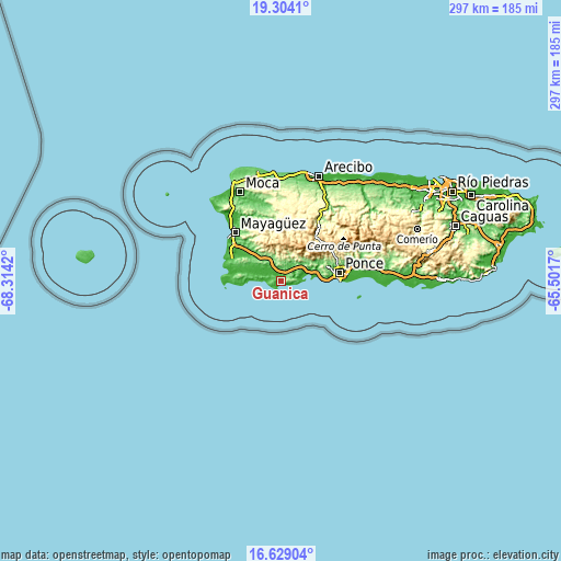
| \ | Map #1 | Map #2 | Topo.Map |
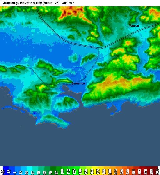
| Scale [m] | -2..218 m | -26..301 m | × |
| Scale [ft] | -7..715 ft | -85..988 ft | × |
| Average | 52.4 m = 172 ft | 60.6 m = 199 ft | × |
| Width | 9.3 km = 5.8 mi | 18.59 km = 11.6 mi | 297.4 km = 184.8 mi |
| Height | 9.3 km = 5.8 mi | 18.59 km = 11.6 mi | 297.5 km = 184.9 mi |
| ↑Max Latitude | 18.013426° | 18.055213° | 19.3041° |
| Latitude at center | 17.97163° | 17.97163° | 17.97163° |
| ↓Min Latitude | 17.929824° | 17.888008° | 16.62904° |
| ← Min Longitude | -66.951895° | -66.995841° | -68.3142° |
| Longitude center | -66.90795° | -66.90795° | -66.90795° |
| →Max Longitude | -66.864005° | -66.820059° | -65.5017° |
Nearby cities:
Cities around Guánica sort by population:
• Yauco elevation 46 m
9.3 km,  41°
41°
• Sabana Grande 98 m
13 km,  334°
334°
• Lajas 58 m
18.2 km,  298°
298°
• Guayanilla 16 m
13.4 km,  66°
66°
• Palomas 44 m
5.9 km, 38°
• Lluveras 100 m
7.4 km,  2°
2°
• Indios 45 m
9.7 km,  75°
75°
• Maria Antonia 43 m
2.1 km, 69°
• Liborio Negron Torres 64 m
8.7 km,  335°
335°
• Fuig 6 m
2 km, 334°
• La Parguera 11 m
14.7 km,  271°
271°
• Magas Arriba 31 m
15.5 km, 70°
Multilingual:
 En español:
Guánica elevación 7 m.
 En France:
Guánica élévation 7 m.


Sources and notes:
- [note 1] Map square and city borders are not equal. Map elevation data is calculated only from area inside that square.
- [src 1] Elevation data from geonames database provided with same terms of usage.
- [src 2] The elevation map of Guánica is generated using elevation data from NASA's 3 arcsec (90m) resolution SRTM data.
- [src 3] Base (background) map © OpenStreetMap contributors tiles are generated by Geofabrik and OpenTopoMap.
Copyright & License:
This Guánica Elevation Map is licensed under CC BY-SA. You may reuse any part from this page, if you give a proper credit by linking to this URL:
 More info on terms of use page.