Coco elevation
Coco (Salinas, Lapa Barrio), Puerto Rico elevation is 43 meters and Coco elevation in feet is 141 ft above sea level [src 1]. Coco is a populated place (feature code) with elevation that is 57 meters (187 ft) smaller than average city elevation in Puerto Rico.
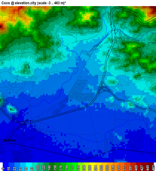
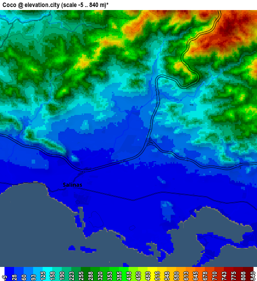
Below is the Elevation map of Coco, which displays elevation range with different colors. Scale of the first map is from -3 to 463 m (-10 to 1519 ft) with average elevation of 74.4 meters (=244 ft) [note 1]
These maps also provides idea of topography and contour of this city, they are displayed at different zoom levels. More info about maps, scale and edge coordinates you can find below images.
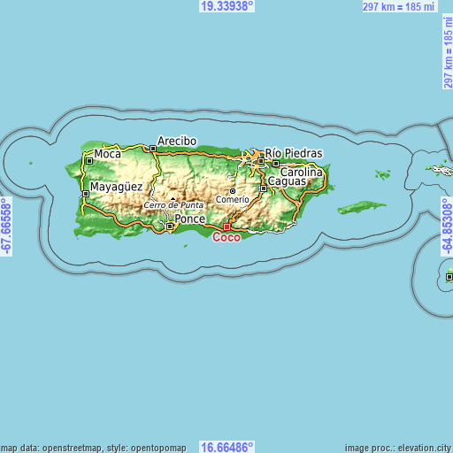
| \ | Map #1 | Map #2 | Topo.Map |
| Scale [m] | -3..463 m | -5..840 m | × |
| Scale [ft] | -10..1519 ft | -16..2756 ft | × |
| Average | 74.4 m = 244 ft | 170.2 m = 558 ft | × |
| Width | 9.29 km = 5.8 mi | 18.59 km = 11.6 mi | 297.4 km = 184.8 mi |
| Height | 9.29 km = 5.8 mi | 18.59 km = 11.6 mi | 297.4 km = 184.8 mi |
| ↑Max Latitude | 18.048978° | 18.090756° | 19.33938° |
| Latitude at center | 18.00719° | 18.00719° | 18.00719° |
| ↓Min Latitude | 17.965392° | 17.923585° | 16.66486° |
| ← Min Longitude | -66.303275° | -66.347221° | -67.66558° |
| Longitude center | -66.25933° | -66.25933° | -66.25933° |
| →Max Longitude | -66.215385° | -66.171439° | -64.85308° |
Nearby cities:
Cities around Coco sort by population:
• Salinas elevation 9 m
5.3 km,  231°
231°
• Coquí 9 m
5 km,  137°
137°
• Jobos 7 m
11.5 km,  120°
120°
• Mariano Colón 111 m
7.9 km,  283°
283°
• Vázquez 157 m
6.9 km,  18°
18°
• Jauca 2 m
12 km,  249°
249°
• Central Aguirre 9 m
7.1 km,  147°
147°
• Pastos 655 m
12.3 km,  0°
0°
• Las Ochenta 14 m
6.7 km, 248°
• Parcelas Peñuelas 43 m
8.7 km,  263°
263°
• Palmarejo 241 m
9.7 km,  314°
314°
• La Plena 183 m
7.3 km,  52°
52°
Multilingual:
 En español:
Coco elevación 43 m.
 En France:
Coco élévation 43 m.


Sources and notes:
- [note 1] Map square and city borders are not equal. Map elevation data is calculated only from area inside that square.
- [src 1] Elevation data from geonames database provided with same terms of usage.
- [src 2] The elevation map of Coco is generated using elevation data from NASA's 3 arcsec (90m) resolution SRTM data.
- [src 3] Base (background) map © OpenStreetMap contributors tiles are generated by Geofabrik and OpenTopoMap.
Copyright & License:
This Coco Elevation Map is licensed under CC BY-SA. You may reuse any part from this page, if you give a proper credit by linking to this URL:
 More info on terms of use page.