Arroyo elevation
Arroyo, Puerto Rico elevation is 7 meters and Arroyo elevation in feet is 23 ft above sea level [src 1]. Arroyo is a seat of a first-order administrative division (feature code) with elevation that is 93 meters (305 ft) smaller than average city elevation in Puerto Rico.
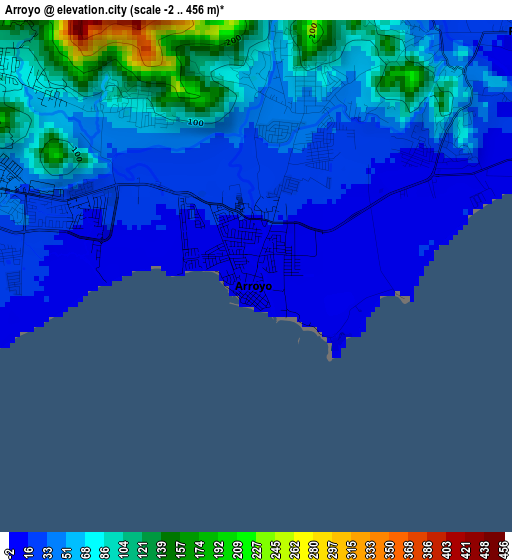
Below is the Elevation map of Arroyo, which displays elevation range with different colors. Scale of the first map is from -2 to 456 m (-7 to 1496 ft) with average elevation of 55.4 meters (=182 ft) [note 1]
These maps also provides idea of topography and contour of this city, they are displayed at different zoom levels. More info about maps, scale and edge coordinates you can find below images.
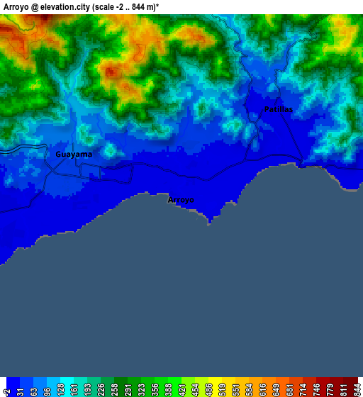
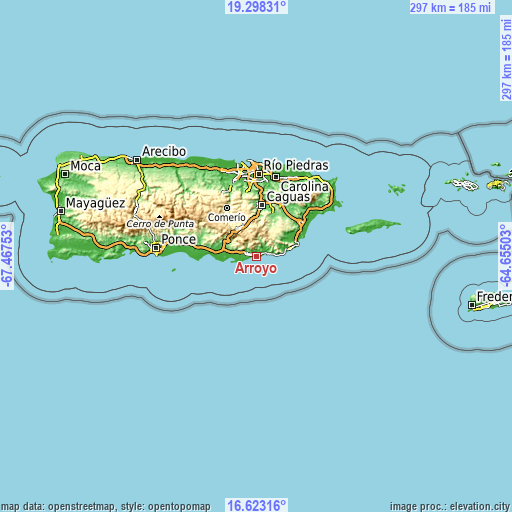
| \ | Map #1 | Map #2 | Topo.Map |
| Scale [m] | -2..456 m | -2..844 m | × |
| Scale [ft] | -7..1496 ft | -7..2769 ft | × |
| Average | 55.4 m = 182 ft | 182.4 m = 598 ft | × |
| Width | 9.3 km = 5.8 mi | 18.59 km = 11.6 mi | 297.4 km = 184.8 mi |
| Height | 9.3 km = 5.8 mi | 18.59 km = 11.6 mi | 297.5 km = 184.9 mi |
| ↑Max Latitude | 18.007598° | 18.049385° | 19.29831° |
| Latitude at center | 17.9658° | 17.9658° | 17.9658° |
| ↓Min Latitude | 17.923992° | 17.882175° | 16.62316° |
| ← Min Longitude | -66.105225° | -66.149171° | -67.46753° |
| Longitude center | -66.06128° | -66.06128° | -66.06128° |
| →Max Longitude | -66.017335° | -65.973389° | -64.65503° |
Nearby cities:
Cities around Arroyo sort by population:
• Guayama elevation 74 m
5.9 km,  290°
290°
• Patillas 21 m
6.6 km,  46°
46°
• Coquí 9 m
17.6 km,  273°
273°
• Jobos 7 m
11.1 km,  263°
263°
• Corazón 62 m
3.9 km,  320°
320°
• Palmas 68 m
4.5 km,  57°
57°
• Olimpo 94 m
6.4 km,  308°
308°
• Buena Vista 55 m
3.5 km,  16°
16°
• Central Aguirre 9 m
17.2 km, 265°
• Yaurel 210 m
6.8 km,  3°
3°
• Palo Seco 77 m
14 km,  70°
70°
• Lamboglia 35 m
8.2 km,  77°
77°
Multilingual:
 En español:
Arroyo elevación 7 m.
 En France:
Arroyo élévation 7 m.


Sources and notes:
- [note 1] Map square and city borders are not equal. Map elevation data is calculated only from area inside that square.
- [src 1] Elevation data from geonames database provided with same terms of usage.
- [src 2] The elevation map of Arroyo is generated using elevation data from NASA's 3 arcsec (90m) resolution SRTM data.
- [src 3] Base (background) map © OpenStreetMap contributors tiles are generated by Geofabrik and OpenTopoMap.
Copyright & License:
This Arroyo Elevation Map is licensed under CC BY-SA. You may reuse any part from this page, if you give a proper credit by linking to this URL:
 More info on terms of use page.