Brody elevation
Brody (Świętokrzyskie, Powiat starachowicki), Poland elevation is 190 meters and Brody elevation in feet is 623 ft above sea level [src 1]. Brody is a seat of a third-order administrative division (feature code) with elevation that is 1 meters (3 ft) smaller than average city elevation in Poland.
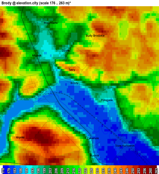
Below is the Elevation map of Brody, which displays elevation range with different colors. Scale of the first map is from 176 to 263 m (577 to 863 ft) with average elevation of 215.7 meters (=708 ft) [note 1]
These maps also provides idea of topography and contour of this city, they are displayed at different zoom levels. More info about maps, scale and edge coordinates you can find below images.
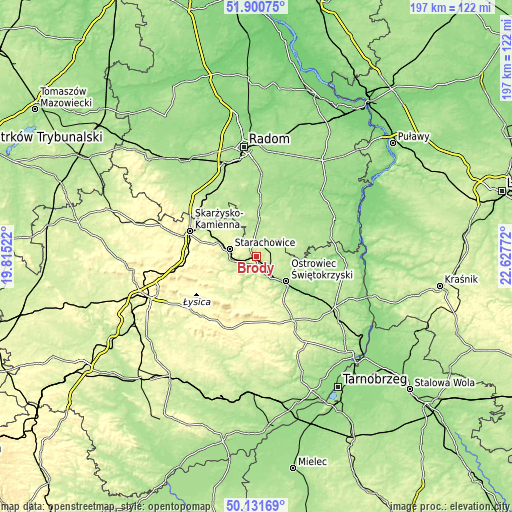
| \ | Map #1 | Topo.Map |
| Scale [m] | 176..263 m | × |
| Scale [ft] | 577..863 ft | × |
| Average | 215.7 m = 708 ft | × |
| Width | 6.15 km = 3.8 mi | 196.7 km = 122.2 mi |
| Height | 6.15 km = 3.8 mi | 196.7 km = 122.2 mi |
| ↑Max Latitude | 51.052293° | 51.90075° |
| Latitude at center | 51.02466° | 51.02466° |
| ↓Min Latitude | 50.997011° | 50.13169° |
| ← Min Longitude | 21.177525° | 19.81522° |
| Longitude center | 21.22147° | 21.22147° |
| →Max Longitude | 21.265415° | 22.62772° |
Nearby cities:
Cities around Brody sort by population:
• Ostrowiec Świętokrzyski elevation 176 m
15.6 km,  132°
132°
• Starachowice 210 m
10.6 km,  277°
277°
• Iłża 182 m
15.4 km,  4°
4°
• Kunów 177 m
8.1 km,  149°
149°
• Wąchock 215 m
15.6 km,  290°
290°
• Mirzec 214 m
16.8 km,  316°
316°
• Wielka Wieś 286 m
18.6 km, 286°
• Pawłów 268 m
9.9 km,  225°
225°
• Sienno 190 m
19.6 km,  69°
69°
• Rzeczniów 182 m
19.1 km,  53°
53°
• Waśniów 257 m
14 km,  179°
179°
• Bodzechów 167 m
20 km, 130°
Multilingual:
 En español:
Brody elevación 190 m.
 En France:
Brody élévation 190 m.


Sources and notes:
- [note 1] Map square and city borders are not equal. Map elevation data is calculated only from area inside that square.
- [src 1] Elevation data from geonames database provided with same terms of usage.
- [src 2] The elevation map of Brody is generated using elevation data from NASA's 3 arcsec (90m) resolution SRTM data.
- [src 3] Base (background) map © OpenStreetMap contributors tiles are generated by Geofabrik and OpenTopoMap.
Copyright & License:
This Brody Elevation Map is licensed under CC BY-SA. You may reuse any part from this page, if you give a proper credit by linking to this URL:
 More info on terms of use page.