Rzeczniów elevation
Rzeczniów (Mazovia, Powiat lipski), Poland elevation is 182 meters and Rzeczniów elevation in feet is 597 ft above sea level [src 1]. Rzeczniów is a seat of a third-order administrative division (feature code) with elevation that is 9 meters (30 ft) smaller than average city elevation in Poland.
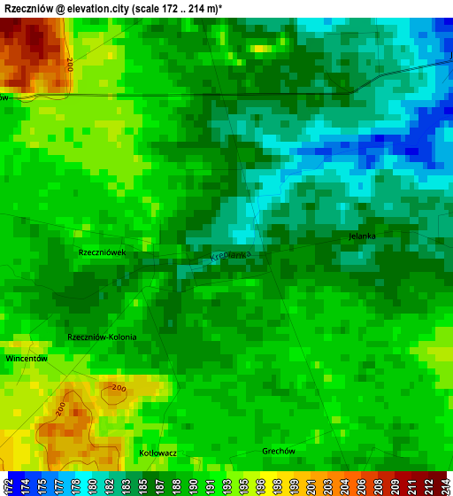
Below is the Elevation map of Rzeczniów, which displays elevation range with different colors. Scale of the first map is from 172 to 214 m (564 to 702 ft) with average elevation of 188.7 meters (=619 ft) [note 1]
These maps also provides idea of topography and contour of this city, they are displayed at different zoom levels. More info about maps, scale and edge coordinates you can find below images.
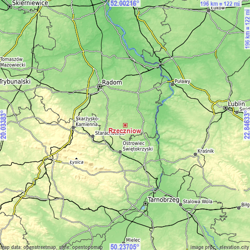
| \ | Map #1 | Topo.Map |
| Scale [m] | 172..214 m | × |
| Scale [ft] | 564..702 ft | × |
| Average | 188.7 m = 619 ft | × |
| Width | 6.13 km = 3.8 mi | 196.3 km = 122 mi |
| Height | 6.13 km = 3.8 mi | 196.2 km = 121.9 mi |
| ↑Max Latitude | 51.155611° | 52.00216° |
| Latitude at center | 51.12804° | 51.12804° |
| ↓Min Latitude | 51.100452° | 50.23705° |
| ← Min Longitude | 21.396135° | 20.03383° |
| Longitude center | 21.44008° | 21.44008° |
| →Max Longitude | 21.484025° | 22.84633° |
Nearby cities:
Cities around Rzeczniów sort by population:
• Ostrowiec Świętokrzyski elevation 176 m
22.4 km,  189°
189°
• Lipsko 162 m
15 km,  76°
76°
• Iłża 182 m
14.5 km,  285°
285°
• Kunów 177 m
21.6 km,  211°
211°
• Brody 190 m
19.1 km,  233°
233°
• Solec Nad Wisłą 156 m
22.7 km,  87°
87°
• Tarłów 161 m
23.8 km,  126°
126°
• Ciepielów 148 m
16.3 km,  35°
35°
• Sienno 190 m
5.4 km,  146°
146°
• Bałtów 154 m
14.2 km, 149°
• Tczów 170 m
22 km,  1°
1°
• Kazanów 153 m
16.6 km,  6°
6°
Multilingual:
 En español:
Rzeczniów elevación 182 m.
 En France:
Rzeczniów élévation 182 m.
 Auf Deutsch:
Rzeczniów höhe über dem Meeresspiegel ist 182 m.

Sources and notes:
- [note 1] Map square and city borders are not equal. Map elevation data is calculated only from area inside that square.
- [src 1] Elevation data from geonames database provided with same terms of usage.
- [src 2] The elevation map of Rzeczniów is generated using elevation data from NASA's 3 arcsec (90m) resolution SRTM data.
- [src 3] Base (background) map © OpenStreetMap contributors tiles are generated by Geofabrik and OpenTopoMap.
Copyright & License:
This Rzeczniów Elevation Map is licensed under CC BY-SA. You may reuse any part from this page, if you give a proper credit by linking to this URL:
 More info on terms of use page.