Cegłów elevation
Cegłów (Mazovia, Powiat miński), Poland elevation is 167 meters and Cegłów elevation in feet is 548 ft above sea level [src 1]. Cegłów is a seat of a third-order administrative division (feature code) with elevation that is 24 meters (79 ft) smaller than average city elevation in Poland.
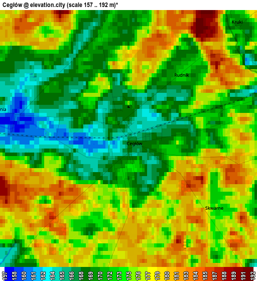
Below is the Elevation map of Cegłów, which displays elevation range with different colors. Scale of the first map is from 157 to 192 m (515 to 630 ft) with average elevation of 174 meters (=571 ft) [note 1]
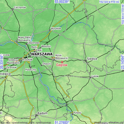
These maps also provides idea of topography and contour of this city, they are displayed at different zoom levels. More info about maps, scale and edge coordinates you can find below images.
| \ | Map #1 | Topo.Map |
| Scale [m] | 157..192 m | × |
| Scale [ft] | 515..630 ft | × |
| Average | 174 m = 571 ft | × |
| Width | 6 km = 3.7 mi | 191.9 km = 119.2 mi |
| Height | 6 km = 3.7 mi | 191.9 km = 119.2 mi |
| ↑Max Latitude | 52.174778° | 53.00239° |
| Latitude at center | 52.14782° | 52.14782° |
| ↓Min Latitude | 52.120846° | 51.27653° |
| ← Min Longitude | 21.693445° | 20.33114° |
| Longitude center | 21.73739° | 21.73739° |
| →Max Longitude | 21.781335° | 23.14364° |
Nearby cities:
Cities around Cegłów sort by population:
• Mińsk Mazowiecki elevation 150 m
11.8 km,  287°
287°
• Mrozy 164 m
4.9 km,  65°
65°
• Kołbiel 115 m
19.8 km,  242°
242°
• Kałuszyn 179 m
8.1 km,  36°
36°
• Siennica 144 m
10.2 km,  232°
232°
• Dobre 159 m
19.7 km,  348°
348°
• Latowicz 146 m
14.3 km,  160°
160°
• Parysów 144 m
19.5 km,  191°
191°
• Wodynie 163 m
19.1 km,  128°
128°
• Jakubów 181 m
8.9 km,  334°
334°
• Wierzbno 151 m
19.9 km,  24°
24°
• Grębków 145 m
17.9 km, 41°
Multilingual:
 En español:
Cegłów elevación 167 m.
 En France:
Cegłów élévation 167 m.


Sources and notes:
- [note 1] Map square and city borders are not equal. Map elevation data is calculated only from area inside that square.
- [src 1] Elevation data from geonames database provided with same terms of usage.
- [src 2] The elevation map of Cegłów is generated using elevation data from NASA's 3 arcsec (90m) resolution SRTM data.
- [src 3] Base (background) map © OpenStreetMap contributors tiles are generated by Geofabrik and OpenTopoMap.
Copyright & License:
This Cegłów Elevation Map is licensed under CC BY-SA. You may reuse any part from this page, if you give a proper credit by linking to this URL:
 More info on terms of use page.