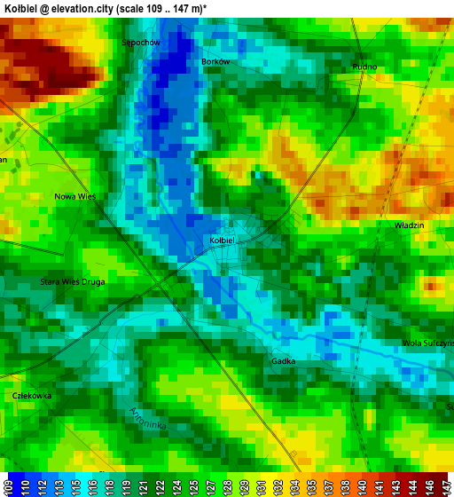
Kołbiel elevation
Kołbiel (Mazovia, Powiat otwocki), Poland elevation is 115 meters and Kołbiel elevation in feet is 377 ft above sea level [src 1]. Kołbiel is a seat of a third-order administrative division (feature code) with elevation that is 76 meters (249 ft) smaller than average city elevation in Poland.
Below is the Elevation map of Kołbiel, which displays elevation range with different colors. Scale of the first map is from 109 to 147 m (358 to 482 ft) with average elevation of 124 meters (=407 ft) [note 1]
These maps also provides idea of topography and contour of this city, they are displayed at different zoom levels. More info about maps, scale and edge coordinates you can find below images.
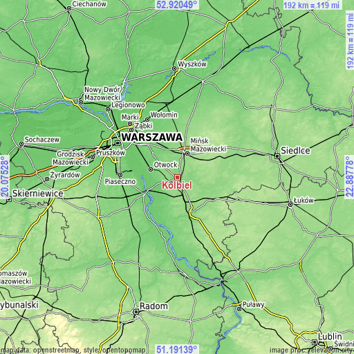
| \ | Map #1 | Topo.Map |
| Scale [m] | 109..147 m | × |
| Scale [ft] | 358..482 ft | × |
| Average | 124 m = 407 ft | × |
| Width | 6.01 km = 3.7 mi | 192.3 km = 119.5 mi |
| Height | 6.01 km = 3.7 mi | 192.2 km = 119.4 mi |
| ↑Max Latitude | 52.091318° | 52.92049° |
| Latitude at center | 52.06431° | 52.06431° |
| ↓Min Latitude | 52.037285° | 51.19139° |
| ← Min Longitude | 21.437585° | 20.07528° |
| Longitude center | 21.48153° | 21.48153° |
| →Max Longitude | 21.525475° | 22.88778° |
Nearby cities:
Cities around Kołbiel sort by population:
• Otwock elevation 94 m
15.7 km,  287°
287°
• Mińsk Mazowiecki 150 m
14.2 km,  25°
25°
• Józefów 93 m
18.6 km,  295°
295°
• Karczew 90 m
15.9 km,  274°
274°
• Pilawa 148 m
12.1 km,  163°
163°
• Celestynów 135 m
6.2 km, 266°
• Dębe Wielkie 126 m
15.3 km,  350°
350°
• Siennica 144 m
9.9 km,  72°
72°
• Trąbki 149 m
15.2 km,  148°
148°
• Miętne 137 m
17.1 km, 158°
• Parysów 144 m
16.8 km,  125°
125°
• Osieck 112 m
11.7 km,  201°
201°
Multilingual:
 En español:
Kołbiel elevación 115 m.
 En France:
Kołbiel élévation 115 m.


Sources and notes:
- [note 1] Map square and city borders are not equal. Map elevation data is calculated only from area inside that square.
- [src 1] Elevation data from geonames database provided with same terms of usage.
- [src 2] The elevation map of Kołbiel is generated using elevation data from NASA's 3 arcsec (90m) resolution SRTM data.
- [src 3] Base (background) map © OpenStreetMap contributors tiles are generated by Geofabrik and OpenTopoMap.
Copyright & License:
This Kołbiel Elevation Map is licensed under CC BY-SA. You may reuse any part from this page, if you give a proper credit by linking to this URL:
 More info on terms of use page.