Frysztak elevation
Frysztak (Subcarpathian, Powiat strzyżowski), Poland elevation is 249 meters and Frysztak elevation in feet is 817 ft above sea level [src 1]. Frysztak is a seat of a third-order administrative division (feature code) with elevation that is 58 meters (190 ft) bigger than average city elevation in Poland.
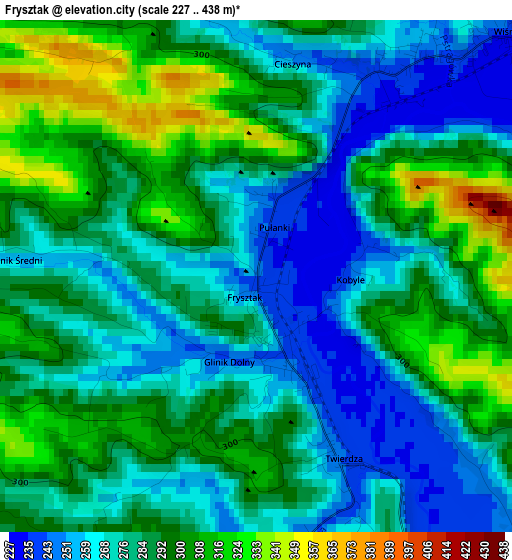
Below is the Elevation map of Frysztak, which displays elevation range with different colors. Scale of the first map is from 227 to 438 m (745 to 1437 ft) with average elevation of 284.2 meters (=932 ft) [note 1]
These maps also provides idea of topography and contour of this city, they are displayed at different zoom levels. More info about maps, scale and edge coordinates you can find below images.
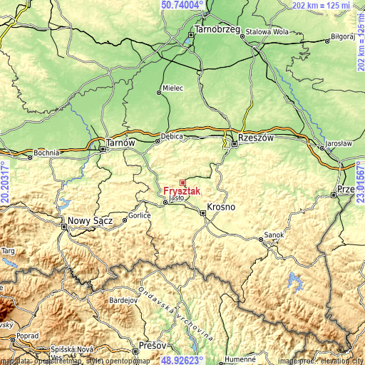
| \ | Map #1 | Topo.Map |
| Scale [m] | 227..438 m | × |
| Scale [ft] | 745..1437 ft | × |
| Average | 284.2 m = 932 ft | × |
| Width | 6.3 km = 3.9 mi | 201.7 km = 125.3 mi |
| Height | 6.3 km = 3.9 mi | 201.7 km = 125.3 mi |
| ↑Max Latitude | 49.869972° | 50.74004° |
| Latitude at center | 49.84164° | 49.84164° |
| ↓Min Latitude | 49.813291° | 48.92623° |
| ← Min Longitude | 21.565475° | 20.20317° |
| Longitude center | 21.60942° | 21.60942° |
| →Max Longitude | 21.653365° | 23.01567° |
Nearby cities:
Cities around Frysztak sort by population:
• Jasło elevation 231 m
14.6 km,  222°
222°
• Strzyżów 232 m
13.6 km,  76°
76°
• Jedlicze 263 m
14.1 km,  168°
168°
• Wielopole Skrzyńskie 256 m
11.6 km,  1°
1°
• Odrzykoń 268 m
14.7 km,  140°
140°
• Brzostek 227 m
14.8 km,  286°
286°
• Wysoka Strzyżowska 243 m
9.5 km,  97°
97°
• Wiśniowa 241 m
4.5 km,  47°
47°
• Kołaczyce 224 m
13.1 km,  253°
253°
• Tarnowiec 269 m
12.5 km,  190°
190°
• Łęki 264 m
5.1 km,  134°
134°
• Wojaszówka 256 m
8.4 km,  148°
148°
Multilingual:
 En español:
Frysztak elevación 249 m.
 En France:
Frysztak élévation 249 m.
 Auf Deutsch:
Frysztak höhe über dem Meeresspiegel ist 249 m.

Sources and notes:
- [note 1] Map square and city borders are not equal. Map elevation data is calculated only from area inside that square.
- [src 1] Elevation data from geonames database provided with same terms of usage.
- [src 2] The elevation map of Frysztak is generated using elevation data from NASA's 3 arcsec (90m) resolution SRTM data.
- [src 3] Base (background) map © OpenStreetMap contributors tiles are generated by Geofabrik and OpenTopoMap.
Copyright & License:
This Frysztak Elevation Map is licensed under CC BY-SA. You may reuse any part from this page, if you give a proper credit by linking to this URL:
 More info on terms of use page.