Jedlińsk elevation
Jedlińsk (Mazovia, Powiat radomski), Poland elevation is 127 meters and Jedlińsk elevation in feet is 417 ft above sea level [src 1]. Jedlińsk is a seat of a third-order administrative division (feature code) with elevation that is 64 meters (210 ft) smaller than average city elevation in Poland.
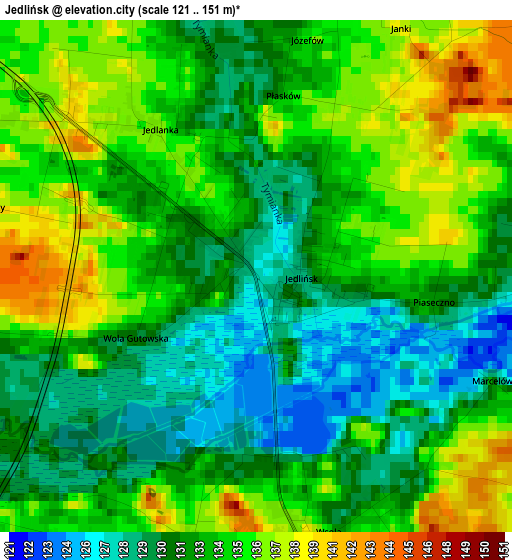
Below is the Elevation map of Jedlińsk, which displays elevation range with different colors. Scale of the first map is from 121 to 151 m (397 to 495 ft) with average elevation of 133.1 meters (=437 ft) [note 1]
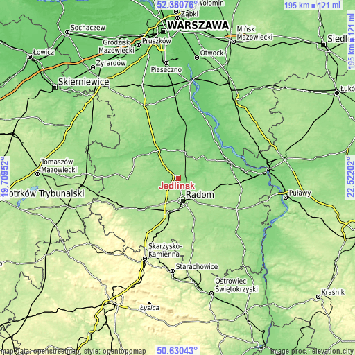
These maps also provides idea of topography and contour of this city, they are displayed at different zoom levels. More info about maps, scale and edge coordinates you can find below images.
| \ | Map #1 | Topo.Map |
| Scale [m] | 121..151 m | × |
| Scale [ft] | 397..495 ft | × |
| Average | 133.1 m = 437 ft | × |
| Width | 6.08 km = 3.8 mi | 194.6 km = 120.9 mi |
| Height | 6.08 km = 3.8 mi | 194.6 km = 120.9 mi |
| ↑Max Latitude | 51.54134° | 52.38076° |
| Latitude at center | 51.514° | 51.514° |
| ↓Min Latitude | 51.486644° | 50.63043° |
| ← Min Longitude | 21.071825° | 19.70952° |
| Longitude center | 21.11577° | 21.11577° |
| →Max Longitude | 21.159715° | 22.52202° |
Nearby cities:
Cities around Jedlińsk sort by population:
• Radom elevation 159 m
12.6 km,  170°
170°
• Białobrzegi 114 m
18.7 km,  322°
322°
• Jedlnia-Letnisko 157 m
17.8 km,  121°
121°
• Trablice 179 m
18 km,  177°
177°
• Sucha 124 m
16.5 km, 315°
• Jastrzębia 145 m
8.6 km,  102°
102°
• Przytyk 146 m
15.5 km,  249°
249°
• Stromiec 130 m
14.9 km,  353°
353°
• Wolanów 184 m
17.7 km,  212°
212°
• Radzanów 158 m
18.1 km,  285°
285°
• Zakrzew 161 m
11.4 km,  224°
224°
• Stara Błotnica 152 m
10.4 km, 290°
Multilingual:
 En español:
Jedlińsk elevación 127 m.
 En France:
Jedlińsk élévation 127 m.
 Auf Deutsch:
Jedlińsk höhe über dem Meeresspiegel ist 127 m.

Sources and notes:
- [note 1] Map square and city borders are not equal. Map elevation data is calculated only from area inside that square.
- [src 1] Elevation data from geonames database provided with same terms of usage.
- [src 2] The elevation map of Jedlińsk is generated using elevation data from NASA's 3 arcsec (90m) resolution SRTM data.
- [src 3] Base (background) map © OpenStreetMap contributors tiles are generated by Geofabrik and OpenTopoMap.
Copyright & License:
This Jedlińsk Elevation Map is licensed under CC BY-SA. You may reuse any part from this page, if you give a proper credit by linking to this URL:
 More info on terms of use page.