Kłaj elevation
Kłaj (Lesser Poland, Powiat wielicki), Poland elevation is 211 meters and Kłaj elevation in feet is 692 ft above sea level [src 1]. Kłaj is a seat of a third-order administrative division (feature code) with elevation that is 20 meters (66 ft) bigger than average city elevation in Poland.
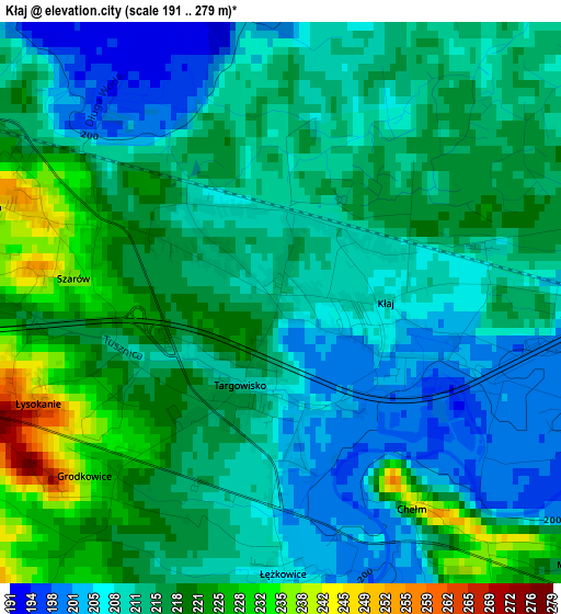
Below is the Elevation map of Kłaj, which displays elevation range with different colors. Scale of the first map is from 191 to 279 m (627 to 915 ft) with average elevation of 213.8 meters (=701 ft) [note 1]
These maps also provides idea of topography and contour of this city, they are displayed at different zoom levels. More info about maps, scale and edge coordinates you can find below images.
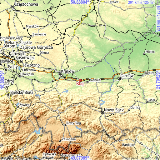
| \ | Map #1 | Topo.Map |
| Scale [m] | 191..279 m | × |
| Scale [ft] | 627..915 ft | × |
| Average | 213.8 m = 701 ft | × |
| Width | 6.28 km = 3.9 mi | 201 km = 124.9 mi |
| Height | 6.28 km = 3.9 mi | 201 km = 124.9 mi |
| ↑Max Latitude | 50.020704° | 50.88804° |
| Latitude at center | 49.99246° | 49.99246° |
| ↓Min Latitude | 49.9642° | 49.07989° |
| ← Min Longitude | 20.255095° | 18.89279° |
| Longitude center | 20.29904° | 20.29904° |
| →Max Longitude | 20.342985° | 21.70529° |
Nearby cities:
Cities around Kłaj sort by population:
• Bochnia elevation 218 m
9.7 km,  105°
105°
• Niepołomice 190 m
7.7 km,  314°
314°
• Gdów 228 m
11.8 km,  217°
217°
• Wola Batorska 187 m
7.1 km,  340°
340°
• Podłęże 203 m
9.7 km,  284°
284°
• Łapczyca 238 m
7.1 km,  120°
120°
• Zabierzów Bocheński 186 m
8.5 km,  9°
9°
• Targowisko 212 m
0.9 km,  204°
204°
• Szarów 229 m
2.1 km, 277°
• Stanisławice 199 m
3.8 km,  101°
101°
• Trąbki 296 m
11.7 km,  253°
253°
• Wola Zabierzowska 187 m
9.2 km, 14°
Multilingual:
 En español:
Kłaj elevación 211 m.
 En France:
Kłaj élévation 211 m.


Sources and notes:
- [note 1] Map square and city borders are not equal. Map elevation data is calculated only from area inside that square.
- [src 1] Elevation data from geonames database provided with same terms of usage.
- [src 2] The elevation map of Kłaj is generated using elevation data from NASA's 3 arcsec (90m) resolution SRTM data.
- [src 3] Base (background) map © OpenStreetMap contributors tiles are generated by Geofabrik and OpenTopoMap.
Copyright & License:
This Kłaj Elevation Map is licensed under CC BY-SA. You may reuse any part from this page, if you give a proper credit by linking to this URL:
 More info on terms of use page.