Koszyce elevation
Koszyce (Lesser Poland, Powiat tarnowski), Poland elevation is 221 meters and Koszyce elevation in feet is 725 ft above sea level [src 1]. Koszyce is a populated place (feature code) with elevation that is 30 meters (98 ft) bigger than average city elevation in Poland.
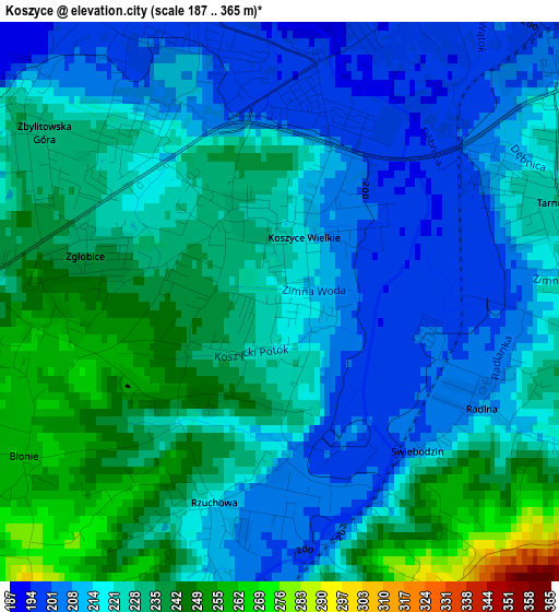
Below is the Elevation map of Koszyce, which displays elevation range with different colors. Scale of the first map is from 187 to 365 m (614 to 1198 ft) with average elevation of 223.2 meters (=732 ft) [note 1]
These maps also provides idea of topography and contour of this city, they are displayed at different zoom levels. More info about maps, scale and edge coordinates you can find below images.
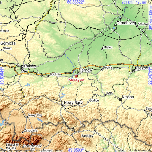
| \ | Map #1 | Topo.Map |
| Scale [m] | 187..365 m | × |
| Scale [ft] | 614..1198 ft | × |
| Average | 223.2 m = 732 ft | × |
| Width | 6.29 km = 3.9 mi | 201.1 km = 125 mi |
| Height | 6.29 km = 3.9 mi | 201.1 km = 125 mi |
| ↑Max Latitude | 50.000515° | 50.86822° |
| Latitude at center | 49.97226° | 49.97226° |
| ↓Min Latitude | 49.943988° | 49.0593° |
| ← Min Longitude | 20.897715° | 19.53541° |
| Longitude center | 20.94166° | 20.94166° |
| →Max Longitude | 20.985605° | 22.34791° |
Nearby cities:
Cities around Koszyce sort by population:
• Tarnów elevation 220 m
5.6 km,  35°
35°
• Tuchów 231 m
11.8 km,  136°
136°
• Skrzyszów 219 m
8.9 km,  74°
74°
• Wojnicz 203 m
7.6 km,  257°
257°
• Szynwałd 250 m
13 km,  92°
92°
• Wierzchosławice 193 m
8.4 km,  313°
313°
• Koszyce Wielkie 212 m
1 km,  16°
16°
• Siedliska 241 m
11.9 km,  160°
160°
• Pleśna 216 m
5.1 km,  177°
177°
• Tarnowiec 234 m
3.4 km, 71°
• Wielka Wieś 214 m
9.4 km,  244°
244°
• Janowice 234 m
10.7 km,  212°
212°
Multilingual:
 En español:
Koszyce elevación 221 m.
 En France:
Koszyce élévation 221 m.


Sources and notes:
- [note 1] Map square and city borders are not equal. Map elevation data is calculated only from area inside that square.
- [src 1] Elevation data from geonames database provided with same terms of usage.
- [src 2] The elevation map of Koszyce is generated using elevation data from NASA's 3 arcsec (90m) resolution SRTM data.
- [src 3] Base (background) map © OpenStreetMap contributors tiles are generated by Geofabrik and OpenTopoMap.
Copyright & License:
This Koszyce Elevation Map is licensed under CC BY-SA. You may reuse any part from this page, if you give a proper credit by linking to this URL:
 More info on terms of use page.