Tuchów elevation
Tuchów (Lesser Poland, Powiat tarnowski), Poland elevation is 231 meters and Tuchów elevation in feet is 758 ft above sea level [src 1]. Tuchów is a seat of a third-order administrative division (feature code) with elevation that is 40 meters (131 ft) bigger than average city elevation in Poland.
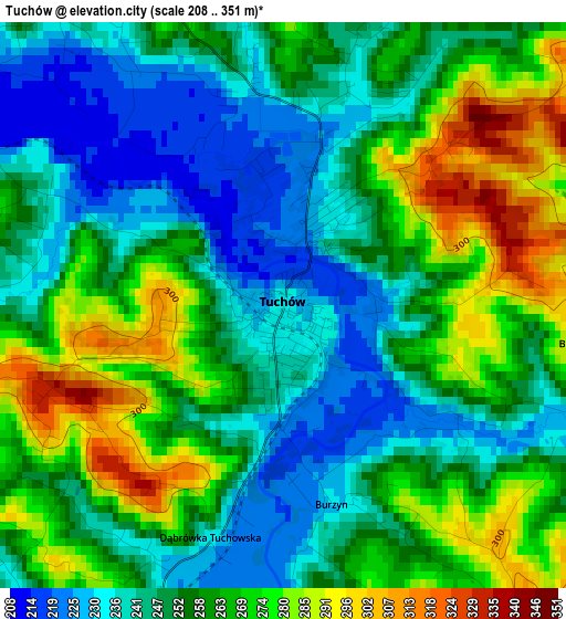
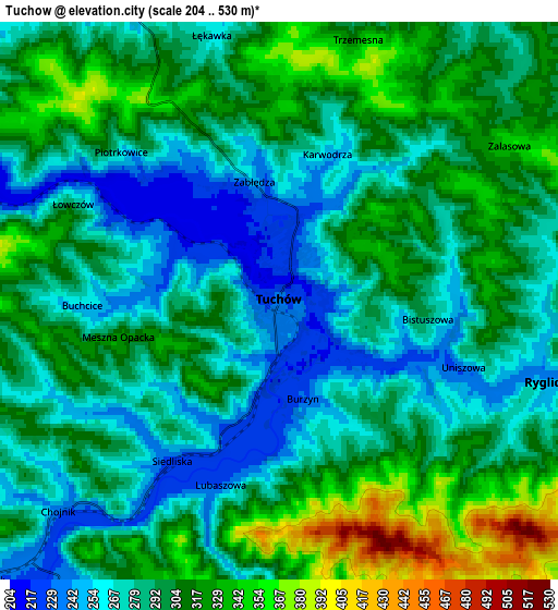
Below is the Elevation map of Tuchów, which displays elevation range with different colors. Scale of the first map is from 208 to 351 m (682 to 1152 ft) with average elevation of 256 meters (=840 ft) [note 1]
These maps also provides idea of topography and contour of this city, they are displayed at different zoom levels. More info about maps, scale and edge coordinates you can find below images.
| \ | Map #1 | Map #2 | Topo.Map |
| Scale [m] | 208..351 m | 204..530 m | × |
| Scale [ft] | 682..1152 ft | 669..1739 ft | × |
| Average | 256 m = 840 ft | 295.2 m = 969 ft | × |
| Width | 6.3 km = 3.9 mi | 12.59 km = 7.8 mi | 201.5 km = 125.2 mi |
| Height | 6.3 km = 3.9 mi | 12.59 km = 7.8 mi | 201.4 km = 125.1 mi |
| ↑Max Latitude | 49.923151° | 49.951435° | 50.79226° |
| Latitude at center | 49.89485° | 49.89485° | 49.89485° |
| ↓Min Latitude | 49.866532° | 49.838198° | 48.98044° |
| ← Min Longitude | 21.010125° | 20.966179° | 19.64782° |
| Longitude center | 21.05407° | 21.05407° | 21.05407° |
| →Max Longitude | 21.098015° | 21.141961° | 22.46032° |
Nearby cities:
Cities around Tuchów sort by population:
• Skrzyszów elevation 219 m
11 km,  2°
2°
• Gromnik 239 m
9.1 km,  226°
226°
• Szynwałd 250 m
9.5 km,  31°
31°
• Ryglice 241 m
6.2 km,  106°
106°
• Siedliska 241 m
4.9 km,  238°
238°
• Żurowa 299 m
11.2 km,  132°
132°
• Siemiechów 254 m
11.6 km,  246°
246°
• Pleśna 216 m
8.5 km,  294°
294°
• Koszyce 221 m
11.8 km,  316°
316°
• Łęki Górne 243 m
12.3 km,  44°
44°
• Tarnowiec 234 m
10.8 km,  333°
333°
• Rzepiennik Strzyżewski 250 m
10 km,  187°
187°
Multilingual:
 En español:
Tuchów elevación 231 m.
 En France:
Tuchów élévation 231 m.


Sources and notes:
- [note 1] Map square and city borders are not equal. Map elevation data is calculated only from area inside that square.
- [src 1] Elevation data from geonames database provided with same terms of usage.
- [src 2] The elevation map of Tuchów is generated using elevation data from NASA's 3 arcsec (90m) resolution SRTM data.
- [src 3] Base (background) map © OpenStreetMap contributors tiles are generated by Geofabrik and OpenTopoMap.
Copyright & License:
This Tuchów Elevation Map is licensed under CC BY-SA. You may reuse any part from this page, if you give a proper credit by linking to this URL:
 More info on terms of use page.