Krasnobród elevation
Krasnobród (Lublin, Powiat zamojski), Poland elevation is 256 meters and Krasnobród elevation in feet is 840 ft above sea level [src 1]. Krasnobród is a seat of a third-order administrative division (feature code) with elevation that is 65 meters (213 ft) bigger than average city elevation in Poland.
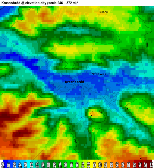
Below is the Elevation map of Krasnobród, which displays elevation range with different colors. Scale of the first map is from 246 to 372 m (807 to 1220 ft) with average elevation of 296.1 meters (=971 ft) [note 1]
These maps also provides idea of topography and contour of this city, they are displayed at different zoom levels. More info about maps, scale and edge coordinates you can find below images.
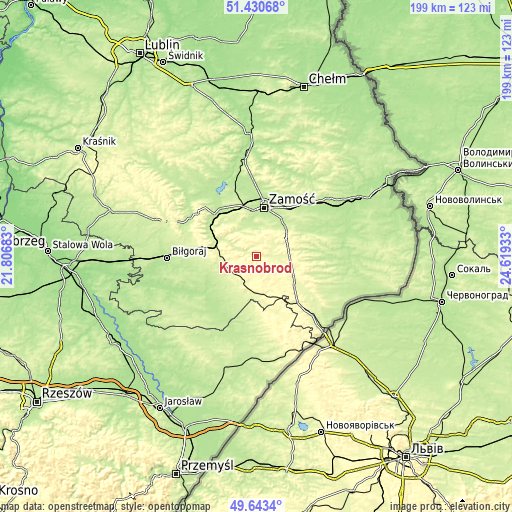
| \ | Map #1 | Topo.Map |
| Scale [m] | 246..372 m | × |
| Scale [ft] | 807..1220 ft | × |
| Average | 296.1 m = 971 ft | × |
| Width | 6.21 km = 3.9 mi | 198.7 km = 123.5 mi |
| Height | 6.21 km = 3.9 mi | 198.7 km = 123.5 mi |
| ↑Max Latitude | 50.573427° | 51.43068° |
| Latitude at center | 50.54551° | 50.54551° |
| ↓Min Latitude | 50.517576° | 49.6434° |
| ← Min Longitude | 23.169135° | 21.80683° |
| Longitude center | 23.21308° | 23.21308° |
| →Max Longitude | 23.257025° | 24.61933° |
Nearby cities:
Cities around Krasnobród sort by population:
• Zamość elevation 213 m
19.9 km,  7°
7°
• Tomaszów Lubelski 274 m
18 km,  127°
127°
• Szczebrzeszyn 214 m
23.4 km,  315°
315°
• Zwierzyniec 225 m
18.4 km,  294°
294°
• Józefów 248 m
13.3 km,  237°
237°
• Narol 271 m
23.3 km,  159°
159°
• Łabunie 225 m
16.3 km,  41°
41°
• Susiec 263 m
14 km,  184°
184°
• Rogóźno 273 m
15.5 km, 125°
• Komarów-Osada 213 m
20.8 km,  63°
63°
• Tarnawatka 278 m
13 km,  96°
96°
• Krynice 269 m
12.8 km,  68°
68°
Multilingual:
 En español:
Krasnobród elevación 256 m.
 En France:
Krasnobród élévation 256 m.
 Auf Deutsch:
Krasnobród höhe über dem Meeresspiegel ist 256 m.

Sources and notes:
- [note 1] Map square and city borders are not equal. Map elevation data is calculated only from area inside that square.
- [src 1] Elevation data from geonames database provided with same terms of usage.
- [src 2] The elevation map of Krasnobród is generated using elevation data from NASA's 3 arcsec (90m) resolution SRTM data.
- [src 3] Base (background) map © OpenStreetMap contributors tiles are generated by Geofabrik and OpenTopoMap.
Copyright & License:
This Krasnobród Elevation Map is licensed under CC BY-SA. You may reuse any part from this page, if you give a proper credit by linking to this URL:
 More info on terms of use page.