Krynice elevation
Krynice (Lublin, Powiat tomaszowski), Poland elevation is 269 meters and Krynice elevation in feet is 883 ft above sea level [src 1]. Krynice is a seat of a third-order administrative division (feature code) with elevation that is 78 meters (256 ft) bigger than average city elevation in Poland.
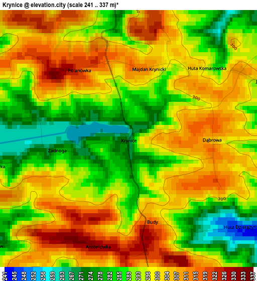
Below is the Elevation map of Krynice, which displays elevation range with different colors. Scale of the first map is from 241 to 337 m (791 to 1106 ft) with average elevation of 296.2 meters (=972 ft) [note 1]
These maps also provides idea of topography and contour of this city, they are displayed at different zoom levels. More info about maps, scale and edge coordinates you can find below images.
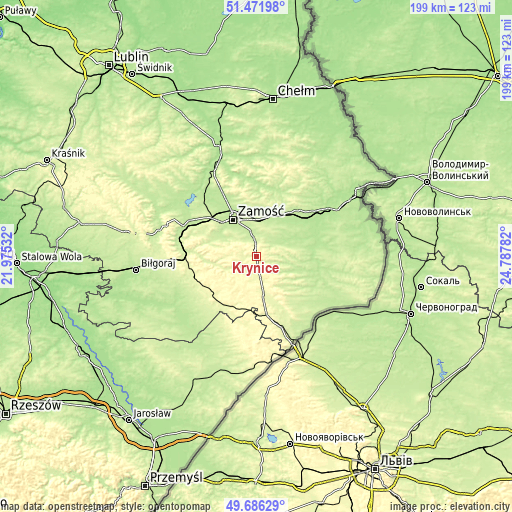
| \ | Map #1 | Topo.Map |
| Scale [m] | 241..337 m | × |
| Scale [ft] | 791..1106 ft | × |
| Average | 296.2 m = 972 ft | × |
| Width | 6.2 km = 3.9 mi | 198.6 km = 123.4 mi |
| Height | 6.2 km = 3.9 mi | 198.5 km = 123.3 mi |
| ↑Max Latitude | 50.615493° | 51.47198° |
| Latitude at center | 50.5876° | 50.5876° |
| ↓Min Latitude | 50.559691° | 49.68629° |
| ← Min Longitude | 23.337625° | 21.97532° |
| Longitude center | 23.38157° | 23.38157° |
| →Max Longitude | 23.425515° | 24.78782° |
Nearby cities:
Cities around Krynice sort by population:
• Zamość elevation 213 m
17.6 km,  328°
328°
• Tomaszów Lubelski 274 m
15.7 km,  171°
171°
• Krasnobród 256 m
12.8 km,  248°
248°
• Tyszowce 198 m
22.7 km,  81°
81°
• Łabunie 225 m
7.6 km,  351°
351°
• Michałów 208 m
16.3 km,  106°
106°
• Rogóźno 273 m
13.7 km,  177°
177°
• Komarów-Osada 213 m
8.2 km,  55°
55°
• Tarnawatka 278 m
6.3 km, 170°
• Rachanie 226 m
12.9 km,  115°
115°
• Miączyn 222 m
18.8 km,  26°
26°
• Sitno 213 m
18 km,  355°
355°
Multilingual:
 En español:
Krynice elevación 269 m.
 En France:
Krynice élévation 269 m.


Sources and notes:
- [note 1] Map square and city borders are not equal. Map elevation data is calculated only from area inside that square.
- [src 1] Elevation data from geonames database provided with same terms of usage.
- [src 2] The elevation map of Krynice is generated using elevation data from NASA's 3 arcsec (90m) resolution SRTM data.
- [src 3] Base (background) map © OpenStreetMap contributors tiles are generated by Geofabrik and OpenTopoMap.
Copyright & License:
This Krynice Elevation Map is licensed under CC BY-SA. You may reuse any part from this page, if you give a proper credit by linking to this URL:
 More info on terms of use page.