Krzywda elevation
Krzywda (Lublin, Powiat łukowski), Poland elevation is 167 meters and Krzywda elevation in feet is 548 ft above sea level [src 1]. Krzywda is a populated place (feature code) with elevation that is 24 meters (79 ft) smaller than average city elevation in Poland.
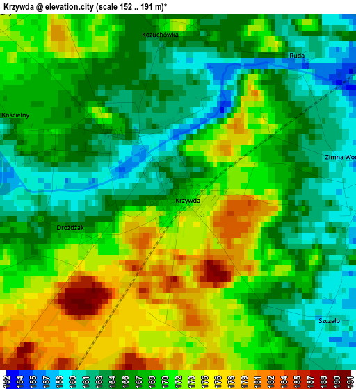
Below is the Elevation map of Krzywda, which displays elevation range with different colors. Scale of the first map is from 152 to 191 m (499 to 627 ft) with average elevation of 168.1 meters (=552 ft) [note 1]
These maps also provides idea of topography and contour of this city, they are displayed at different zoom levels. More info about maps, scale and edge coordinates you can find below images.
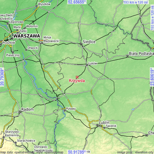
| \ | Map #1 | Topo.Map |
| Scale [m] | 152..191 m | × |
| Scale [ft] | 499..627 ft | × |
| Average | 168.1 m = 552 ft | × |
| Width | 6.04 km = 3.8 mi | 193.4 km = 120.2 mi |
| Height | 6.04 km = 3.8 mi | 193.4 km = 120.2 mi |
| ↑Max Latitude | 51.822361° | 52.65655° |
| Latitude at center | 51.79519° | 51.79519° |
| ↓Min Latitude | 51.768003° | 50.91705° |
| ← Min Longitude | 22.155995° | 20.79369° |
| Longitude center | 22.19994° | 22.19994° |
| →Max Longitude | 22.243885° | 23.60619° |
Nearby cities:
Cities around Krzywda sort by population:
• Łuków elevation 159 m
19.3 km,  39°
39°
• Żelechów 171 m
20.9 km,  274°
274°
• Kock 139 m
24.1 km,  135°
135°
• Adamów 157 m
7.3 km, 142°
• Ułęż 143 m
23.5 km,  195°
195°
• Przytoczno 136 m
20.1 km,  165°
165°
• Wojcieszków 152 m
8.5 km,  109°
109°
• Serokomla 151 m
13.9 km, 139°
• Kłoczew 157 m
18.1 km,  243°
243°
• Jeziorzany 127 m
22.1 km, 166°
• Borki 152 m
23.6 km, 110°
• Nowodwór 157 m
18.6 km, 201°
Multilingual:
 En español:
Krzywda elevación 167 m.
 En France:
Krzywda élévation 167 m.


Sources and notes:
- [note 1] Map square and city borders are not equal. Map elevation data is calculated only from area inside that square.
- [src 1] Elevation data from geonames database provided with same terms of usage.
- [src 2] The elevation map of Krzywda is generated using elevation data from NASA's 3 arcsec (90m) resolution SRTM data.
- [src 3] Base (background) map © OpenStreetMap contributors tiles are generated by Geofabrik and OpenTopoMap.
Copyright & License:
This Krzywda Elevation Map is licensed under CC BY-SA. You may reuse any part from this page, if you give a proper credit by linking to this URL:
 More info on terms of use page.