Miechów elevation
Miechów (Lesser Poland, Powiat miechowski), Poland elevation is 298 meters and Miechów elevation in feet is 978 ft above sea level [src 1]. Miechów is a seat of a second-order administrative division (feature code) with elevation that is 107 meters (351 ft) bigger than average city elevation in Poland.
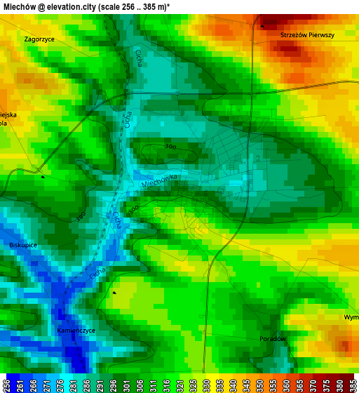
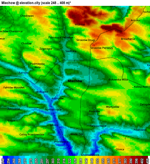
Below is the Elevation map of Miechów, which displays elevation range with different colors. Scale of the first map is from 256 to 385 m (840 to 1263 ft) with average elevation of 309.6 meters (=1016 ft) [note 1]
These maps also provides idea of topography and contour of this city, they are displayed at different zoom levels. More info about maps, scale and edge coordinates you can find below images.
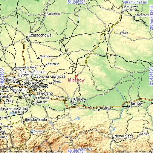
| \ | Map #1 | Map #2 | Topo.Map |
| Scale [m] | 256..385 m | 248..408 m | × |
| Scale [ft] | 840..1263 ft | 814..1339 ft | × |
| Average | 309.6 m = 1016 ft | 317.7 m = 1042 ft | × |
| Width | 6.23 km = 3.9 mi | 12.47 km = 7.7 mi | 199.5 km = 124 mi |
| Height | 6.23 km = 3.9 mi | 12.47 km = 7.7 mi | 199.5 km = 124 mi |
| ↑Max Latitude | 50.384509° | 50.412522° | 51.24522° |
| Latitude at center | 50.35648° | 50.35648° | 50.35648° |
| ↓Min Latitude | 50.328434° | 50.300372° | 49.45079° |
| ← Min Longitude | 19.983935° | 19.939989° | 18.62163° |
| Longitude center | 20.02788° | 20.02788° | 20.02788° |
| →Max Longitude | 20.071825° | 20.115771° | 21.43413° |
Nearby cities:
Cities around Miechów sort by population:
• Wolbrom elevation 375 m
19.3 km,  277°
277°
• Sędziszów 253 m
23.4 km,  4°
4°
• Słomniki 251 m
13.5 km,  163°
163°
• Sułoszowa 420 m
23.2 km,  244°
244°
• Skała 417 m
18.7 km,  221°
221°
• Miechów Charsznica 316 m
7 km,  308°
308°
• Michałowice 247 m
22.2 km,  188°
188°
• Sąspów 453 m
23.2 km,  232°
232°
• Zarzecze 364 m
23.6 km,  272°
272°
• Wodzisław 244 m
21.6 km,  32°
32°
• Działoszyce 213 m
23 km,  87°
87°
• Kozłów 288 m
14.2 km,  359°
359°
Multilingual:
 En español:
Miechów elevación 298 m.
 En France:
Miechów élévation 298 m.


Sources and notes:
- [note 1] Map square and city borders are not equal. Map elevation data is calculated only from area inside that square.
- [src 1] Elevation data from geonames database provided with same terms of usage.
- [src 2] The elevation map of Miechów is generated using elevation data from NASA's 3 arcsec (90m) resolution SRTM data.
- [src 3] Base (background) map © OpenStreetMap contributors tiles are generated by Geofabrik and OpenTopoMap.
Copyright & License:
This Miechów Elevation Map is licensed under CC BY-SA. You may reuse any part from this page, if you give a proper credit by linking to this URL:
 More info on terms of use page.